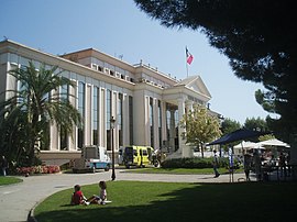
Alpes-Maritimes is a department of France located in the country's southeast corner, on the Italian border and Mediterranean coast. Part of the Provence-Alpes-Côte d'Azur region, it encompasses the French Riviera alongside neighbouring Var. Alpes-Maritimes had a population of 1,083,310 in 2017. Its prefecture is Nice, with Grasse as the sole subprefecture.

Provence-Alpes-Côte d'Azur is one of the eighteen administrative regions of France, the far southeastern on the mainland. Its prefecture and largest city is Marseille. The region is roughly coterminous with the former French province of Provence, with the addition of the following adjacent areas: the former papal territory of Avignon, known as Comtat Venaissin; the former Sardinian-Piedmontese County of Nice annexed in 1860, whose coastline is known in English as the French Riviera and in French as the Côte d'Azur; and the southeastern part of the former French province of Dauphiné, in the French Alps. Previously known by the acronym PACA, the region adopted the name Région Sud as a commercial name or nickname in December 2017. 5,007,977 people live in the region according to the 2015 census.

The French Riviera is the Mediterranean coastline of the southeast corner of France. There is no official boundary, but it is usually considered to extend from Toulon, Le Lavandou or Saint-Tropez in the west to Menton at the France–Italy border in the east. The coast is entirely within the Provence-Alpes-Côte d'Azur region of France. The Principality of Monaco is a semi-enclave within the region, surrounded on three sides by France and fronting the Mediterranean. The French Riviera contains the seaside resorts of Cap-d'Ail, Beaulieu-sur-Mer, Saint-Jean-Cap-Ferrat, Villefranche-sur-Mer, Antibes, Juan-les-Pins, Cannes, Saint-Raphaël, Fréjus, Sainte-Maxime and Saint-Tropez.

The Urban community of Nice Côte d'Azur, is the former intercommunal structure gathering the city of Nice (France) and some of its suburbs. It was created in December 2008.
Utelle is a commune about 40 miles (64 km) northeast of Nice in the Alpes-Maritimes department in southeastern France.

Saint-Raphaël is a commune in the Var department, Provence-Alpes-Côte d'Azur region, Southeastern France. In 2017, it had a population of 35,042.

Èze is a seaside commune in the Alpes-Maritimes department in the Provence-Alpes-Côte d'Azur region in Southeastern France. It is located on the French Riviera, 8.5 km to the northeast of Nice and 4.5 km to the west of Monaco. In 2018, Èze had a population of 2,225. Its inhabitants are known as Ezasques.

Cagnes-sur-Mer is a French Riviera town in the Alpes-Maritimes department in the Provence-Alpes-Côte d'Azur region in southeastern France.

Colomars is a commune in the Alpes-Maritimes département in the Provence-Alpes-Côte d'Azur region in southeastern France.

Nice metropolitan area as defined by INSEE is a residential area near Nice. It has 933,020 inhabitants and an area that covers a large strip of territory from the city of Villefranche-sur-Mer to the westernmost part of the Alpes-Maritimes département, including cities like Antibes, Grasse, Cannes and Cagnes-sur-Mer.

Coaraze is a commune in the Alpes-Maritimes department in the Provence-Alpes-Côte d'Azur region in southeastern France.

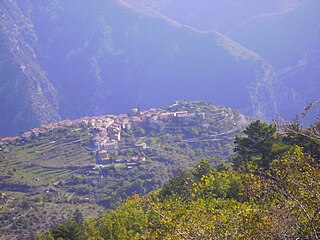
Bairols is a commune in the Alpes-Maritimes department in the Provence-Alpes-Côte d'Azur region of south-eastern France.

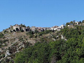
Aspremont is a commune in the Alpes-Maritimes department in the Provence-Alpes-Côte d'Azur region of south-eastern France.

La Roquette-sur-Var is a commune in the Alpes-Maritimes department in southeastern France. It is one of sixteen villages grouped together by the Métropole Nice Côte d'Azur tourist department as the Route des Villages Perchés. The others are: Aspremont, Carros, Castagniers, Coaraze, Colomars, Duranus, Èze, Falicon, La Gaude, Lantosque, Levens, Saint-Blaise, Saint-Jeannet, Tourrette-Levens and Utelle.

Saint-Jeannet is a commune in the Alpes-Maritimes department in southeastern France.
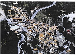
Lantosque is a commune in the Alpes-Maritimes department in southeastern France. It is one of sixteen villages grouped together by the Métropole Nice Côte d'Azur tourist department as the Route des Villages Perchés. The others are: Aspremont, Carros, Castagniers, Coaraze, Colomars, Duranus, Èze, Falicon, La Gaude, Levens, La Roquette-sur-Var, Saint-Blaise, Saint-Jeannet, Tourrette-Levens and Utelle.
Le Mas is a commune in the Alpes-Maritimes department in the Provence-Alpes-Côte d'Azur region of South-eastern France.

The Canton of Saint-Laurent-du-Var-Cagnes-sur-Mer-Est is a former French canton, located in the arrondissement of Grasse, in the Alpes-Maritimes département. It had 37,102 inhabitants (2012).

Métropole Nice Côte d'Azur is the métropole, an intercommunal structure, centred on the city of Nice. It is located in the Alpes-Maritimes department, in the Provence-Alpes-Côte d'Azur region, southeastern France. It was created in December 2011, replacing the previous Communauté urbaine Nice Côte d'Azur and the communautés de communes of les stations du Mercantour, La Tinée and Vésubie-Mercantour. In 2013 the commune Coaraze left the métropole, and in 2014 the communes Bonson, Le Broc, Gattières and Gilette joined it. In January 2022 the communes Drap and Châteauneuf-Villevieille joined the métropole. Its area is 1479.7 km2. Its population was 545,873 in 2018, of which 341,032 are located in Nice proper.

Saint-Laurent-du-Var is a train station on the line from Marseille to Ventimiglia, situated in Saint-Laurent-du-Var, west of Nice, in the department of Alpes-Maritimes in the region of Provence-Alpes-Côte d'Azur, France.