Lantosque

Last updated • a couple of secsFrom Wikipedia, The Free Encyclopedia

Lantosque
Lantosca (Occitan)
Lantosque -1.JPG
A view of the village of Lantosque, with the church of Saint-Pons in the upper right
Armoiries Lantosque.svg
Location of Lantosque
Lantosque
France location map-Regions and departements-2016.svg
Red pog.svg
Lantosque
Provence-Alpes-Cotes d'Azur region location map.svg
Red pog.svg
Lantosque
Coordinates: 43°58′28″N7°18′47″E / 43.9744°N 7.3131°E / 43.9744; 7.3131
Country France
Region Provence-Alpes-Côte d'Azur
Department Alpes-Maritimes
Arrondissement Nice
Canton Tourrette-Levens
Intercommunality Métropole Nice Côte d'Azur
Government
  Mayor (20202026) Jean Thaon [1]
Area
1
44.76 km2 (17.28 sq mi)
Population
 (2021) [2]
1,200
  Density27/km2 (69/sq mi)
Time zone UTC+01:00 (CET)
  Summer (DST) UTC+02:00 (CEST)
INSEE/Postal code
06074 /06450
Elevation335–2,000 m (1,099–6,562 ft)
(avg. 512 m or 1,680 ft)
1 French Land Register data, which excludes lakes, ponds, glaciers > 1 km2 (0.386 sq mi or 247 acres) and river estuaries.

Lantosque (French pronunciation: [lɑ̃tɔsk] ; Italian formerly and Occitan: Lantosca) is a commune in the Alpes-Maritimes department in the Provence-Alpes-Côte d'Azur region in Southeastern France.

Contents

Lantosque is one of sixteen picturesque villages grouped together by the Métropole Nice Côte d'Azur tourist office on the Route des Villages Perchés (Route of Perched Villages) itinerary, together with Aspremont, Carros, Castagniers, Coaraze, Colomars, Duranus, Èze, Falicon, La Gaude, Levens, La Roquette-sur-Var, Saint-Blaise, Saint-Jeannet, Tourrette-Levens and Utelle. [3]

Demographics

Historical population
YearPop.±% p.a.
1968 1,057    
1975 884−2.52%
1982 772−1.92%
1990 972+2.92%
1999 1,019+0.53%
2009 1,303+2.49%
2014 1,316+0.20%
2020 1,206−1.44%
Source: INSEE [4]

See also

Related Research Articles

<span class="mw-page-title-main">Alpes-Maritimes</span> Department in Provence-Alpes-Côte dAzur, France

Alpes-Maritimes is a department of France located in the country's southeast corner, on the Italian border and Mediterranean coast. Part of the Provence-Alpes-Côte d'Azur region, it encompasses the French Riviera alongside neighbouring Var. Alpes-Maritimes had a population of 1,094,283 in 2019. Its prefecture is Nice, with Grasse as the sole subprefecture.

<span class="mw-page-title-main">Saint-Laurent-du-Var</span> Commune in Provence-Alpes-Côte dAzur, France

Saint-Laurent-du-Var is a commune in the Alpes-Maritimes department in the Provence-Alpes-Côte d'Azur region on the French Riviera.
<span class="mw-page-title-main">Utelle</span> Commune in Provence-Alpes-Côte dAzur, France

Utelle is a commune about 40 miles (64 km) northeast of Nice in the Alpes-Maritimes department in southeastern France.

<span class="mw-page-title-main">Èze</span> Commune in Provence-Alpes-Côte dAzur, France

Èze is a seaside commune in the Alpes-Maritimes department in the Provence-Alpes-Côte d'Azur region in Southeastern France. It is located on the French Riviera, 8.5 km (5.2 mi) to the northeast of Nice and 4.5 km (2.7 mi) to the west of Monaco. In 2018, Èze had 2,225 inhabitants known as Ezasques.

<span class="mw-page-title-main">Arrondissement of Nice</span> Arrondissement in Provence-Alpes-Côte dAzur, France

The arrondissement of Nice is an arrondissement of France in the Alpes-Maritimes department in the Provence-Alpes-Côte d'Azur region. It has 101 communes. Its population is 522,637 (2016), and its area is 3,067.4 km2 (1,184.3 sq mi).

<span class="mw-page-title-main">Levens, Alpes-Maritimes</span> Commune in Provence-Alpes-Côte dAzur, France

Levens is a commune in the Alpes-Maritimes département in the Provence-Alpes-Côte d'Azur region in southeastern France.

<span class="mw-page-title-main">Colomars</span> Commune in Provence-Alpes-Côte dAzur, France

Colomars is a commune in the Alpes-Maritimes département in the Provence-Alpes-Côte d'Azur region in southeastern France.

<span class="mw-page-title-main">Coaraze</span> Commune in Provence-Alpes-Côte dAzur, France

Coaraze is a commune in the Alpes-Maritimes department in the Provence-Alpes-Côte d'Azur region in southeastern France.

<span class="mw-page-title-main">Duranus</span> Commune in Provence-Alpes-Côte dAzur, France

Duranus is a commune in the Alpes-Maritimes department in southeastern France.

<span class="mw-page-title-main">Aspremont, Alpes-Maritimes</span> Commune in Provence-Alpes-Côte dAzur, France

Aspremont is a commune in the Alpes-Maritimes department in the Provence-Alpes-Côte d'Azur region in Southeastern France.

<span class="mw-page-title-main">La Roquette-sur-Var</span> Commune in Provence-Alpes-Côte dAzur, France

La Roquette-sur-Var is a commune in the Alpes-Maritimes department in southeastern France. It is one of sixteen villages grouped together by the Métropole Nice Côte d'Azur tourist department as the Route des Villages Perchés. The others are: Aspremont, Carros, Castagniers, Coaraze, Colomars, Duranus, Èze, Falicon, La Gaude, Lantosque, Levens, Saint-Blaise, Saint-Jeannet, Tourrette-Levens and Utelle.

<span class="mw-page-title-main">Tourrette-Levens</span> Commune in Provence-Alpes-Côte dAzur, France

Tourrette-Levens is a commune in the Alpes-Maritimes department in southeastern France.

<span class="mw-page-title-main">Saint-Jeannet, Alpes-Maritimes</span> Commune in Provence-Alpes-Côte dAzur, France

Saint-Jeannet is a hilly commune in the Alpes-Maritimes department in the southeastern Provence-Alpes-Côte d'Azur region in France. Located just northeast of Vence, it is part of the Métropole Nice Côte d'Azur.

<span class="mw-page-title-main">Saint-Blaise, Alpes-Maritimes</span> Commune in Provence-Alpes-Côte dAzur, France

Saint-Blaise is a commune in the Alpes-Maritimes département in southeastern France.

<span class="mw-page-title-main">La Gaude</span> Commune in Provence-Alpes-Côte dAzur, France

La Gaude is a commune in the Alpes-Maritimes department in southeastern France.

<span class="mw-page-title-main">Falicon</span> Commune in Provence-Alpes-Côte dAzur, France

Falicon is a commune in the Alpes-Maritimes department in southeastern France.

<span class="mw-page-title-main">Castagniers</span> Commune in Provence-Alpes-Côte dAzur, France

Castagniers is a commune in the Alpes-Maritimes department in southeastern France.
<span class="mw-page-title-main">Carros</span> Commune in Provence-Alpes-Côte dAzur, France

Carros is a commune in the Alpes-Maritimes department in southeastern France. Carros is one of sixteen villages grouped together by the Métropole Nice Côte d'Azur tourist department as the Route des Villages Perchés. The others are: Aspremont, Castagniers, Coaraze, Colomars, Duranus, Èze, Falicon, La Gaude, Lantosque, Levens, La Roquette-sur-Var, Saint-Blaise, Saint-Jeannet, Tourrette-Levens and Utelle.
<span class="mw-page-title-main">Métropole Nice Côte d'Azur</span> Métropole in Provence-Alpes-Côte dAzur, France

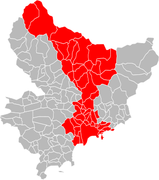
The Métropole Nice Côte d'Azur is the métropole, an intercommunal structure, centred on the city of Nice. It is located in the Alpes-Maritimes department, in the Provence-Alpes-Côte d'Azur region, Southeastern France. It was created on 31 December 2011, replacing the previous communauté urbaine of Nice Côte d'Azur and the communautés de communes of Les stations du Mercantour, La Tinée and Vésubie-Mercantour. In 2013 the commune of Coaraze left the métropole; in 2014 the communes of Bonson, Le Broc, Gattières and Gilette joined it. In 2022 the communes of Drap and Châteauneuf-Villevieille joined the métropole. Its area is 1,479.7 km2. Its population was 545,873 in 2018, of which 341,032 in Nice proper.

<span class="mw-page-title-main">Canton of Tourrette-Levens</span> Canton in Provence-Alpes-Côte dAzur, France

The canton of Tourrette-Levens is an administrative division of the southeastern Alpes-Maritimes department, Provence-Alpes-Côte d'Azur region, France. It was created at the French canton reorganisation which came into effect in March 2015. Its seat is in Tourrette-Levens. In the 2021 election, MP Éric Ciotti and Rimplas Mayor Christelle D'Intorni of The Republicans were elected.

References

  1. "Répertoire national des élus: les maires". data.gouv.fr, Plateforme ouverte des données publiques françaises (in French). 2 December 2020.
  2. "Populations légales 2021" (in French). The National Institute of Statistics and Economic Studies. 28 December 2023.
  3. "The route of perched villages" (PDF). Métropole Nice Côte d'Azur. 2013.
  4. Population en historique depuis 1968, INSEE