Breil-sur-Roya

Last updated • 1 min readFrom Wikipedia, The Free Encyclopedia

Breil-sur-Roya
Breil sur Roya, Tour de la Cruella 3.JPG
The tower of Cruella, in Breil-sur-Roya
Blason ville fr Breil-sur-Roya (Alpes-Maritimes).svg
Location of Breil-sur-Roya
Breil-sur-Roya
France location map-Regions and departements-2016.svg
Red pog.svg
Breil-sur-Roya
Provence-Alpes-Cotes d'Azur region location map.svg
Red pog.svg
Breil-sur-Roya
Coordinates: 43°56′17″N7°30′54″E / 43.9381°N 7.515°E / 43.9381; 7.515
Country France
Region Provence-Alpes-Côte d'Azur
Department Alpes-Maritimes
Arrondissement Nice
Canton Contes
Intercommunality CA Riviera Française
Government
  Mayor (20202026) Sébastien Olharan [1]
Area
1
81.31 km2 (31.39 sq mi)
Population
 (2021) [2]
2,206
  Density27/km2 (70/sq mi)
Demonym Breillois
Time zone UTC+01:00 (CET)
  Summer (DST) UTC+02:00 (CEST)
INSEE/Postal code
06023 /06540
Elevation151–2,080 m (495–6,824 ft)
(avg. 310 m or 1,020 ft)
1 French Land Register data, which excludes lakes, ponds, glaciers > 1 km2 (0.386 sq mi or 247 acres) and river estuaries.

Breil-sur-Roya (French pronunciation: [bʁɛjsyʁʁwaja] , literally Breil on Roya ; Italian : Breglio sul Roia or simply Breglio; Ligurian : Breggio; Occitan : Brelh de Ròia) is a commune in the Alpes-Maritimes department in southeastern France.

Contents

Population

Historical population
YearPop.±% p.a.
1793 932    
1800 1,419+6.19%
1806 1,511+1.05%
1822 1,969+1.67%
1838 2,392+1.22%
1848 2,637+0.98%
1858 2,458−0.70%
1861 2,706+3.26%
1866 2,709+0.02%
1872 2,595−0.71%
1876 2,576−0.18%
1881 2,538−0.30%
1886 2,565+0.21%
1891 2,696+1.00%
1896 2,668−0.21%
1901 2,728+0.45%
1906 2,645−0.62%
YearPop.±% p.a.
1911 2,804+1.17%
1921 5,136+6.24%
1926 2,899−10.81%
1931 2,666−1.66%
1936 2,562−0.79%
1946 1,321−6.41%
1954 2,029+5.51%
1962 1,994−0.22%
1968 2,148+1.25%
1975 2,089−0.40%
1982 2,095+0.04%
1990 2,058−0.22%
1999 2,028−0.16%
2007 2,115+0.53%
2012 2,444+2.93%
2017 2,158−2.46%
Source: EHESS [3] and INSEE (1968-2017) [4]

Geography

Breil-sur-Roya as its name says is located on the scenic and fast moving river Roya within the river's gorge and along the adjacent escarpments. The area features river rafting, swimming, and hiking.

Breil-sur-Roya is one of the towns on the route of the SNCF Train des Merveilles which runs between Nice and Cuneo in Italy. Trains operate seven times each direction as of 2020 and can be taken from Nice (1 + 1/2 hour) for area touring. The line operated by Italy (FS, the Italian State Railroad) from Ventimiglia joints the SNCF line from Nice at Breil-sur-Roya.

Tourism

The GR52, part of the French Grande Randonnée walking trail network links the town to Gorges de Saorge and Vallon de Zouayne.

Breil-sur-Roya is particularly known for trout fishing. The Roya river runs through town and is open to trout anglers from March to September. Part of the trout run is reserved for fly-fishing. Trout anglers share the river with rafters, another popular local sport.

Flood of 2020

The river Roya violently flooded in October 2020. Major damage occurred to both commercial buildings, to residential homes, and to roads all the way downstream to Ventmiglia, Italy, on the seacoast.

Twin towns — sister cities

Breil-sur-Roya is twinned with:

See also

Related Research Articles

<span class="mw-page-title-main">Alpes-Maritimes</span> Department in Provence-Alpes-Côte dAzur, France

Alpes-Maritimes is a department of France located in the country's southeast corner, on the Italian border and Mediterranean coast. Part of the Provence-Alpes-Côte d'Azur region, it encompasses the French Riviera alongside neighbouring Var. Alpes-Maritimes had a population of 1,094,283 in 2019. Its prefecture is Nice, with Grasse as the sole subprefecture.

<span class="mw-page-title-main">Provence-Alpes-Côte d'Azur</span> Administrative region of France

Provence-Alpes-Côte d'Azur, also known as Région Sud, is one of the eighteen administrative regions of France, located at the far southeastern point of the mainland. The main prefecture and largest city is Marseille, France's third largest city after Paris and Lyon and the 2nd largest urban area when combined with aix en Provence with slightly less than one million residents.

<span class="mw-page-title-main">Saint-Laurent-du-Var</span> Commune in Provence-Alpes-Côte dAzur, France

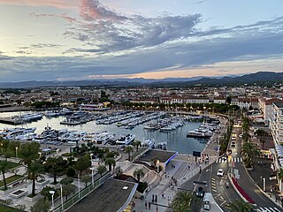
Saint-Laurent-du-Var is a commune in the Alpes-Maritimes department in the Provence-Alpes-Côte d'Azur region on the French Riviera.

<span class="mw-page-title-main">Utelle</span> Commune in Provence-Alpes-Côte dAzur, France

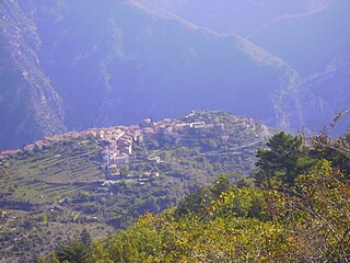
Utelle is a commune about 40 miles (64 km) northeast of Nice in the Alpes-Maritimes department in southeastern France.

<span class="mw-page-title-main">Saint-Raphaël, Var</span> Commune in Provence-Alpes-Côte dAzur, France

Saint-Raphaël is a commune in the Var department, Provence-Alpes-Côte d'Azur region, Southeastern France.

<span class="mw-page-title-main">L'Escarène</span> Commune in Provence-Alpes-Côte dAzur, France

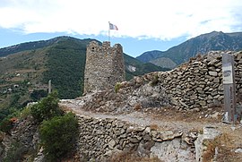
L'Escarène is a commune in the Alpes-Maritimes department in the southeastern Provence-Alpes-Côte d'Azur region in France.

<span class="mw-page-title-main">Arrondissement of Nice</span> Arrondissement in Provence-Alpes-Côte dAzur, France

The arrondissement of Nice is an arrondissement of France in the Alpes-Maritimes department in the Provence-Alpes-Côte d'Azur region. It has 101 communes. Its population is 522,637 (2016), and its area is 3,067.4 km2 (1,184.3 sq mi).

<span class="mw-page-title-main">Chemins de fer de Provence</span>

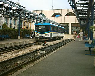
The Chemins de Fer de Provence is a small rail company providing a daily train service between Nice and Digne-les-Bains in Provence. Their single remaining route, which dates from the 1890s and known locally as the Train des Pignes, is a metre-gauge railway, mostly single-track with passing loops at some stations. Between Pont-de-Gueydan and Saint-Sauveur-sur-Tinée the line runs through the valley of the Var. Most stops are upon request only and some do not have a built platform.

<span class="mw-page-title-main">Nice-Ville station</span> Railway station in Nice, France

Nice-Ville station, also known as Nice-Thiers station, is the main railway station of Nice, France. It is situated on the Marseille–Ventimiglia railway and constitutes the southwestern terminus of the Nice–Breil-sur-Roya railway. Nice-Ville is served by TER, Intercités and TGV services, as well as the Gare Thiers stop on Line 1 of the Nice tramway.

<span class="mw-page-title-main">Tende</span> Commune in Provence-Alpes-Côte dAzur, France

Tende is a commune in the Alpes-Maritimes department in southeastern France.

<span class="mw-page-title-main">Montauroux</span> Commune in Provence-Alpes-Côte dAzur, France

Montauroux is a commune in the Var department in the Provence-Alpes-Côte d'Azur region in Southeastern France.

<span class="mw-page-title-main">Roya (river)</span> River in France and Italy

The Roya, Roia (Italian), or Ròia is a river of France and Italy, discharging into the Ligurian Sea. It is 59 km (37 mi) long, of which 40.1 km (24.9 mi) in France. Its drainage basin is about 660 km2 (250 sq mi), of which 601 km2 (232 sq mi) in France.

<span class="mw-page-title-main">Beuil</span> Commune in Provence-Alpes-Côte dAzur, France

Beuil is a commune in the Alpes-Maritimes department in southeastern France.

<span class="mw-page-title-main">Peillon</span> Commune in Provence-Alpes-Côte dAzur, France

Peillon is a rural commune in the Alpes-Maritimes department in the southeastern Provence-Alpes-Côte d'Azur region in France.

<span class="mw-page-title-main">Tourrettes-sur-Loup</span> Commune in Provence-Alpes-Côte dAzur, France

Tourrettes-sur-Loup is a commune in the Alpes-Maritimes department in southeastern France. It has been called Tourrettes-sur-Loup ever since the early twentieth century although prior to that it was known as Tourrettes-les-Vence, a name that arose in the sixteenth century and lasted until the French revolution. This is an artisan's village situated near Vence. It features medieval and Romanesque buildings.

<span class="mw-page-title-main">Saorge</span> Commune in Provence-Alpes-Côte dAzur, France

Saorge is a commune in the Alpes-Maritimes department in southeastern France. It is a member of Les Plus Beaux Villages de France Association. Highway E74 which runs north from Menton, passes through Saorge on its way to the Col de Tende where it crosses into Italy.

<span class="mw-page-title-main">Ventimiglia railway station</span> Railway station in Italy

Ventimiglia railway station is the main station in the Italian town of Ventimiglia. It is at the end of three rail routes: the Genoa–Ventimiglia line, the Cuneo–Ventimiglia line and the Marseille–Ventimiglia line. It plays an important role not only in rail transport in Liguria but also in Italy. Despite being an important station, it is partially in disrepair.

<span class="mw-page-title-main">Marseille–Ventimiglia railway</span> French, Monégasque and Italian railway

The Marseille–Ventimiglia railway is a French-Monégasque-Italian 259-kilometre-long (161 mi) railway line. It opened in several stages between 1858 and 1872.

Royasc is a dialect bridging the gap between the Ligurian language and the Occitan language. It is spoken in Italy and France.

<span class="mw-page-title-main">Canton of Contes</span> Canton of France

The canton of Contes is an administrative division of the Alpes-Maritimes department, southeastern France. Its borders were modified at the French canton reorganisation which came into effect in March 2015. Its seat is in Contes.

References

  1. "Répertoire national des élus: les maires" (in French). data.gouv.fr, Plateforme ouverte des données publiques françaises. 13 September 2022.
  2. "Populations légales 2021" (in French). The National Institute of Statistics and Economic Studies. 28 December 2023.
  3. Des villages de Cassini aux communes d'aujourd'hui: Commune data sheet Breil-sur-Roya, EHESS (in French).
  4. Population en historique depuis 1968, INSEE