Bourg-Saint-Maurice

Last updated • 3 min readFrom Wikipedia, The Free Encyclopedia
Bourg-Saint-Maurice
Bôrg-Sant-Mori (Arpitan)
Bourg-Saint-Maurice, Savoie, France.jpg
A general view of Bourg-Saint-Maurice
Blason ville Fr Bourg-Saint-Maurice (Savoie).svg
Location of Bourg-Saint-Maurice
Bourg-Saint-Maurice
France location map-Regions and departements-2016.svg
Red pog.svg
Bourg-Saint-Maurice
Auvergne-Rhone-Alpes region location map.svg
Red pog.svg
Bourg-Saint-Maurice
Coordinates: 45°37′03″N6°46′10″E / 45.6175°N 6.7694°E / 45.6175; 6.7694
Country France
Region Auvergne-Rhône-Alpes
Department Savoie
Arrondissement Albertville
Canton Bourg-Saint-Maurice
Government
  Mayor (20202026) Guillaume Desrues [1]
Area
1
179.07 km2 (69.14 sq mi)
Population
 (2022) [2]
7,228
  Density40/km2 (100/sq mi)
Time zone UTC+01:00 (CET)
  Summer (DST) UTC+02:00 (CEST)
INSEE/Postal code
73054 /73700
Elevation744–3,823 m (2,441–12,543 ft)
(avg. 815 m or 2,674 ft)
1 French Land Register data, which excludes lakes, ponds, glaciers > 1 km2 (0.386 sq mi or 247 acres) and river estuaries.

Bourg-Saint-Maurice (French pronunciation: [buʁsɛ̃mɔʁis,-moʁ-] ; Arpitan: Bôrg-Sant-Mori or simply Le Bôrg), popularly known as Bourg, is a commune in the Savoie department in the Auvergne-Rhône-Alpes region in south-eastern France. [3] [4] Located on the Italian border south of Chamonix-Mont-Blanc, it had a population of 7,252 as of 2018. It serves as a transport hub for the Paradiski ski area, with direct rail travel from London (Connecting in Lille), and Amsterdam during the winter.

Contents

History

Bergintrum was a place on the Gallic side of the pass of the Alpes Graiae, lying on the road marked in the Antonine Itinerary between Mediolanum (modern Milan) and Vienna (modern Vienne, Isère). Jean-Baptiste Bourguignon d'Anville (Notice, etc.) placed it between Axima (modern Aime) and Alpis Graia. The distance from Bergintrum to Axima, marked viiii M. P. The Alpis Graia, is usually identified with a settlement at the watershed on the Pass of the Little Saint Bernard, which divides the waters that flow to the Isère on the French side from those that flow to the Dora Baltea on the Italian side. This is the place D'Anville calls L'Hôpital, on the authority of a manuscript map of the country. D'Anville first proposed the identification of Bergintrum with Bourg-Saint-Maurice; although he acknowledged that xii, the distance in the Table between Bergintrum and Alpis Graia, does not fit the distance between Bourg-Saint-Maurice and L'Hôpital, which is less. Modern scholarship confirms the identification. [5] In the course of the French Revolution, Bourg-Saint-Maurice was briefly renamed Nargue-Sarde between 1794 and 1815.

Geography

Arc en Ciel funicular railway Arc en Ciel funicular railway.jpg
Arc en Ciel funicular railway

Located in the arrondissement of Albertville in the Savoie department in the Auvergne-Rhône-Alpes region, Bourg-Saint-Maurice is the last town along the Tarentaise Valley in the heart of the French Alps.

Transport

TGVs at Bourg-Saint-Maurice railway station TGV a Bourg-Saint-Maurice (Savoie).JPG
TGVs at Bourg-Saint-Maurice railway station

Bourg-Saint-Maurice station is linked to the TGV network, and has services direct from London (Eurostar) and Amsterdam (Thalys) in the winter. The Arc en Ciel funicular railway links the town to the Arc 1600 ski area.

Climate

Located in the far east of France, Bourg-Saint-Maurice is right on the boundary between the warm-summer humid continental climate (Dfb) and the oceanic climate (Cfb) under the Köppen system. Winters are long, cold, with at least five months of below-freezing temperatures, especially at night. Summers are usually warm and stormy.

Climate data for Bourg-Saint-Maurice (1991−2020 normals, extremes 1946−present)
MonthJanFebMarAprMayJunJulAugSepOctNovDecYear
Record high °C (°F)16.0
(60.8)
21.5
(70.7)
25.6
(78.1)
28.6
(83.5)
33.8
(92.8)
37.6
(99.7)
38.4
(101.1)
37.5
(99.5)
33.1
(91.6)
28.7
(83.7)
23.5
(74.3)
17.6
(63.7)
38.4
(101.1)
Mean daily maximum °C (°F)5.7
(42.3)
7.8
(46.0)
12.8
(55.0)
16.2
(61.2)
20.4
(68.7)
24.5
(76.1)
26.7
(80.1)
26.4
(79.5)
21.9
(71.4)
16.9
(62.4)
10.2
(50.4)
5.7
(42.3)
16.3
(61.3)
Daily mean °C (°F)1.2
(34.2)
2.5
(36.5)
6.7
(44.1)
10.1
(50.2)
14.2
(57.6)
17.8
(64.0)
19.8
(67.6)
19.5
(67.1)
15.6
(60.1)
11.3
(52.3)
5.6
(42.1)
1.7
(35.1)
10.5
(50.9)
Mean daily minimum °C (°F)−3.2
(26.2)
−2.8
(27.0)
0.7
(33.3)
4.1
(39.4)
7.9
(46.2)
11.2
(52.2)
12.9
(55.2)
12.6
(54.7)
9.3
(48.7)
5.7
(42.3)
1.1
(34.0)
−2.2
(28.0)
4.8
(40.6)
Record low °C (°F)−21.3
(−6.3)
−19.6
(−3.3)
−15.1
(4.8)
−7.5
(18.5)
−2.3
(27.9)
0.4
(32.7)
2.9
(37.2)
2.9
(37.2)
−1.2
(29.8)
−6.0
(21.2)
−13.2
(8.2)
−18.1
(−0.6)
−21.3
(−6.3)
Average precipitation mm (inches)100.8
(3.97)
75.9
(2.99)
73.8
(2.91)
57.3
(2.26)
83.2
(3.28)
82.0
(3.23)
81.2
(3.20)
78.4
(3.09)
67.7
(2.67)
77.7
(3.06)
83.9
(3.30)
113.7
(4.48)
975.6
(38.41)
Average precipitation days (≥ 1.0 mm)8.98.38.37.610.910.89.59.28.39.39.29.6110.0
Mean monthly sunshine hours 109.6122.0169.5176.3200.0226.0249.4231.6188.9142.599.293.92,008.8
Source: Météo-France [6]

Population

Historical population
YearPop.±% p.a.
19683,931    
19754,748+2.73%
19825,839+3.00%
19906,056+0.46%
19996,747+1.21%
20077,681+1.63%
20127,741+0.16%
20177,302−1.16%
Source: INSEE [7]

Landmarks

Ouvrage Chatelard is a lesser work (petit ouvrage) of the Maginot Line's Alpine extension, the Alpine Line, also known as the Little Maginot Line. Begun in 1938, the ouvrage consists of one infantry block about one kilometre north-east of the town, in the village of Le Chatelard. A short gallery with cross galleries extends into the rock, with an emergency exit and ventilation shaft halfway back. The ouvrage was incomplete in 1940, under the command of Sub-Lieutenant Bochaton. [8]

Religious sites

The Catholic church of St Maurice is on Grande Rue in the centre of town, the Protestant church is on Avenue Maréchal Leclerc to the south.

Economy

Bourg-Saint-Maurice provides accommodation and a transport hub for the Paradiski ski area. [9]

Notable people

The French ski mountaineer Bertrand Blanc was born in Bourg-Saint-Maurice on 29 October 1973. It is also the birthplace of French politician Hervé Gaymard (31 May 1960).

See also

Related Research Articles

<span class="mw-page-title-main">Albertville</span> Subprefecture of Savoie, Auvergne-Rhône-Alpes, France

Albertville is a subprefecture of the Savoie department in the Auvergne-Rhône-Alpes region in Southeastern France. It is best known for hosting the 1992 Winter Olympics and Paralympics. In 2018, the commune had a population of 19,214; its urban area had 39,780 inhabitants.

<span class="mw-page-title-main">Savoie</span> Department in Auvergne-Rhône-Alpes, France

Savoie is a department in the Auvergne-Rhône-Alpes region, Southeastern France. Located in the French Alps, its prefecture is Chambéry. In 2019, Savoie had a population of 436,434.

<span class="mw-page-title-main">Isère</span> Department in Auvergne-Rhône-Alpes, France

Isère is a landlocked department in the southeastern French region of Auvergne-Rhône-Alpes. Named after the river Isère, it had a population of 1,271,166 in 2019. Its prefecture is Grenoble. It borders Rhône to the northwest, Ain to the north, Savoie to the east, Hautes-Alpes to the south, Drôme and Ardèche to the southwest and Loire to the west.

<span class="mw-page-title-main">Rhône-Alpes</span> Region of France

Rhône-Alpes was an administrative region of France. Since 1 January 2016, it is part of the new region Auvergne-Rhône-Alpes. It is located on the eastern border of the country, towards the south. The region was named after the river Rhône and the Alps mountain range. Its capital, Lyon, is the second-largest metropolitan area in France after Paris. Rhône-Alpes has the sixth-largest economy of any European region.

<span class="mw-page-title-main">Moûtiers</span> Commune in Auvergne-Rhône-Alpes, France

Moûtiers, historically also called Tarentaise, is a commune in the Savoie department in the Auvergne-Rhône-Alpes region in Southeastern France.

<span class="mw-page-title-main">Arrondissement of Albertville</span> Arrondissement in Auvergne-Rhône-Alpes, France

The arrondissement of Albertville is an arrondissement of France in the Savoie department in the Auvergne-Rhône-Alpes region. It has 69 communes. Its population is 112,228 (2021), and its area is 2,466.1 km2 (952.2 sq mi).

<span class="mw-page-title-main">Bellentre</span> Part of La Plagne Tarentaise in Auvergne-Rhône-Alpes, France

Bellentre is a former commune in the Savoie department in the region of Auvergne-Rhône-Alpes in south-eastern France. On 1 January 2016, it was merged into the new commune of La Plagne Tarentaise.

<span class="mw-page-title-main">Aime</span> Part of Aime-la-Plagne in Auvergne-Rhône-Alpes, France

Aime is a former commune in the Savoie département in the Auvergne-Rhône-Alpes region in southeastern France.

<span class="mw-page-title-main">Aime-La Plagne station</span> Railway station in Aime, France

Gare d'Aime-La Plagne is a railway station located in Aime, Savoie, south-eastern France. The station is located on the Saint-Pierre-d'Albigny - Bourg-Saint-Maurice railway. The train services are operated by SNCF. It serves the village of Aime and the neighbouring ski resort, La Plagne. The station is served by TGV and Eurostar high speed services, as well as local TER Auvergne-Rhône-Alpes services.

<span class="mw-page-title-main">Ouvrage Chatelard</span>

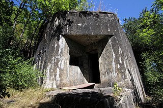
Ouvrage Chatelard is a lesser work of the Maginot Line's Alpine extension, the Alpine Line, also known as the Little Maginot Line. Begun in 1938, the ouvrage consists of one infantry block about one kilometer northeast of Bourg St. Maurice, in the village of Le Chatelard. A short gallery with cross galleries extends into the rock, with an emergency exit and ventilation shaft halfway back. The ouvrage was incomplete in 1940, under the command of Sub-Lieutenant Bochaton.

<span class="mw-page-title-main">Saint-Paul-sur-Isère</span> Commune in Auvergne-Rhône-Alpes, France

Saint-Paul-sur-Isère is a commune in the Savoie department in the Auvergne-Rhône-Alpes region in south-eastern France.

<span class="mw-page-title-main">La Chapelle-Saint-Maurice</span> Commune in Auvergne-Rhône-Alpes, France

La Chapelle-Saint-Maurice is a commune in the Haute-Savoie department in the Auvergne-Rhône-Alpes region in south-eastern France.

<span class="mw-page-title-main">Vallorcine</span> Commune in Auvergne-Rhône-Alpes, France

Vallorcine is a commune in the Haute-Savoie department in the Auvergne-Rhône-Alpes region in southeastern France.

<span class="mw-page-title-main">Villaroger</span> Commune in Auvergne-Rhône-Alpes, France

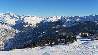
Villaroger is a commune in the Savoie department in the Auvergne-Rhône-Alpes region in south-eastern France. It is situated in the upper Tarentaise Valley, between Bourg-Saint-Maurice and Tignes.

<span class="mw-page-title-main">Moûtiers-Salins-Brides-les-Bains station</span> Railway station in Moûtiers, France

Moûtiers-Salins-Brides-les-Bains station is a railway station in the Savoie department of Southeastern France. The station, which is located in the town of Moûtiers, is served by two major high-speed services: the TGV and Eurostar.

<span class="mw-page-title-main">Chambéry-Challes-les-Eaux station</span> Railway station in Chambéry, France

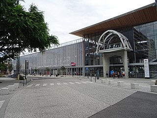
Chambéry-Challes-les-Eaux station is a railway station in the Savoie département of France. The station serves the city of Chambéry. The station is served by three major high speed services, the TGV, Eurostar and Frecciarossa.

<span class="mw-page-title-main">Auvergne-Rhône-Alpes</span> Administrative region of France

Auvergne-Rhône-Alpes is a region in southeast-central France created by the 2014 territorial reform of French regions; it resulted from the merger of Auvergne and Rhône-Alpes. The new region came into effect on 1 January 2016, after the regional elections in December 2015.

<span class="mw-page-title-main">Fortified Sector of Savoy</span>

The Fortified Section of Savoy(Secteur fortifié de la Savoie) was the French military organization that in 1940 controlled the section of the Alpine Line portion of the Maginot Line facing Italy in the Savoy region. The sector constituted part of the Alpine Line portion of the Maginot Line, between the Defensive Sector of the Rhône to the north, and the Fortified Sector of the Dauphiné to the south. The works combined a number of pre-1914 fortifications with Maginot-style ouvrages, with many forward-positioned cavern-style frontier stations or avant-postes that proved effective in holding invading forces near the order.

<span class="mw-page-title-main">Landry station</span> Railway station in Landry, Savoie, France

Gare de Landry is a railway station located in Landry, Savoie, south-eastern France. The station is located on the Saint-Pierre-d'Albigny - Bourg-Saint-Maurice railway. The train services are operated by SNCF. It serves the village of Landry and neighbouring ski resorts of Peisey-Vallandry and Montchavin-les Coches. The station is served by TGV and Eurostar high speed services, as well as local TER Auvergne-Rhône-Alpes services.

<span class="mw-page-title-main">Grésy-sur-Isère station</span> French railway station

Grésy-sur-Isère station is a railway station in Grésy-sur-Isère, Savoie, Southeastern France. The station, opened on 27 October 1879 by the Chemins de fer de Paris à Lyon et à la Méditerranée (PLM), is located on the railway from Saint-Pierre-d'Albigny to Bourg-Saint-Maurice. Train services at Grésy-sur-Isère are operated by the SNCF.

References

  1. "Répertoire national des élus: les maires" (in French). data.gouv.fr, Plateforme ouverte des données publiques françaises. 13 September 2022.
  2. "Populations de référence 2022" (in French). The National Institute of Statistics and Economic Studies. 19 December 2024.
  3. Commune de Bourg-Saint-Maurice (73054), INSEE
  4. "Décret n° 2014-272 du 27 février 2014 portant délimitation des cantons dans le département de la Savoie | Legifrance" . Retrieved 15 December 2023.
  5. Richard Talbert , Barrington Atlas of the Greek and Roman World , ( ISBN   0-691-03169-X ), Map 17.
  6. "Fiche Climatologique Statistiques 1991-2020 et records" (PDF) (in French). Météo-France . Retrieved 4 September 2022.
  7. Population en historique depuis 1968, INSEE
  8. Puelinckx, Jean; Aublet, Jean-Louis; Mainguin, Sylvie (2010). "Chatelard (po de)". Index de la Ligne Maginot (in French). fortiff.be. Retrieved 10 February 2010.
  9. "Bourg St Maurice skiing holidays | ski apartments". Peak Retreats.