Acala Ch'ol

Last updated
Map showing the territory inhabited by the Acala in the 16th century Contact Period lowland Guatemala.gif
Map showing the territory inhabited by the Acala in the 16th century

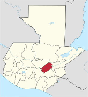
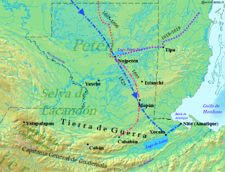
The Acala Ch'ol were a former Ch'ol-speaking Maya people who occupied a territory to the west of the Manche Ch'ol and east of the Chixoy River in what is now the Alta Verapaz Department of Guatemala. [1] The Acala should not be confused with the people of the former Maya territory of Acalan, near the Laguna de Terminos in Mexico. [2]

Maya peoples people of southern Mexico and northern Central America

The Maya peoples are a large group of Indigenous peoples of Mesoamerica. They inhabit southern Mexico, Guatemala, Belize, El Salvador and Honduras. The overarching term "Maya" is a collective designation to include the peoples of the region that share some degree of cultural and linguistic heritage; however, the term embraces many distinct populations, societies, and ethnic groups that each have their own particular traditions, cultures, and historical identity.

Manche Chol

The Manche Ch'ol were a former Ch'ol-speaking Maya people inhabiting the extreme south of what is now the Petén Department of modern Guatemala, the area around Lake Izabal, and southern Belize. The Manche Ch'ol took the name Manche from the name of their main settlement. They were the last group of eastern Cholan-speakers to remain independent and ethnically distinct. It is likely that they were descended from the inhabitants of Classic period Maya cities in the southeastern Maya region, such as Nim Li Punit, Copán and Quiriguá.

The Chixoy River or Río Negro is a river in Guatemala. The river is called Río Negro from its sources in the highlands of Huehuetenango and El Quiché until it reaches the Chixoy hydroelectric dam, where the Río Salamá and Rio Carchela converge with the Río Negro. After the Chixoy dam, the river is called Río Chixoy and flows northwards, marking the departmental limits between Alta Verapaz and El Quiché, until it reaches the border with Mexico. From there on it continues along the border for another 113 kilometres (70 mi) as the Salinas river until it finally converges with the Río la Pasión to form the Usumacinta river which flows into the Gulf of Mexico.

By the 17th century the Acala had two principal towns; Cagbalam had 300 multiple-family houses and Culhuacan had over 140. The towns were divided into four sections, each governed by their own ruler. The combined population of these two towns has been estimated at 7,000. [3] The Acala were allies of the Lakandon Ch'ol, their immediate neighbours to the west, and the two peoples sometimes cooperated militarily. [4] The Acala are known to have cultivated cacao and achiote. [5]

Lakandon Chol Ch’ol-speaking Maya people

The Lakandon Ch'ol were a former Ch’ol-speaking Maya people inhabiting the Lacandon Jungle in what is now lowland Chiapas in Mexico and the bordering regions of northwestern Guatemala, along the tributaries of the upper Usumacinta River and the foothills of the Sierra de los Cuchumatanes.

Cocoa bean Fatty seed of [[Theobroma cacao]] which is the basis of chocolate

The cocoa bean or simply cocoa, which is also called the cacao bean or cacao, is the dried and fully fermented seed of Theobroma cacao, from which cocoa solids and cocoa butter can be extracted. Cocoa beans are the basis of chocolate, and Mesoamerican foods including tejate, a pre-Hispanic drink that also includes maize.

In 1555 the Spanish carried out a military expedition against the Acala in retaliation for their killing of Dominican friar Domingo de Vico and his companion Andrés López. [6] The Spanish and their Christianised Q'eqchi' Maya allies captured 260 Acalas, and hanged 80 of these; the rest were sold as slaves. [7] Many Acala were rounded up by the Q'eqch'i and forcibly moved to settle the San Marcos and San Juan Acala districts of Cobán, capital of colonial Verapaz. Acala from the Chama region were settled in the San Marcos district; the San Juan Acala district received the former inhabitants of the Chisec region. [5] By 1720 the Acala had been completely extinguished, such that there was not even memory of them. [3] Some of the Lakandon and Acala Ch'ols fled their forcible resettlement in Cobán and returned to former Acala territory along the course of the Xoy River, where they became known as the Ah Xoy. [5]

Dominican Order Roman Catholic religious order

The Order of Preachers, also known as the Dominican Order, is a mendicant Catholic religious order founded by the Spanish priest Dominic of Caleruega in France, approved by Pope Honorius III via the Papal bull Religiosam vitam on 22 December 1216. Members of the order, who are referred to as Dominicans, generally carry the letters OP after their names, standing for Ordinis Praedicatorum, meaning of the Order of Preachers. Membership in the order includes friars, nuns, active sisters, and affiliated lay or secular Dominicans.

Domingo de Vico was a Spanish Dominican friar during the Spanish conquest of Chiapas and the conquest of Guatemala in the 16th century. He was originally from Jaén. Chronicler Antonio de Remesal recorded that de Vico studied theology in Úbeda and finished his studies in the San Esteban convent in Salamanca.

Cobán Place in Alta Verapaz, Guatemala

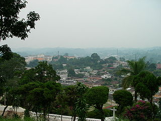
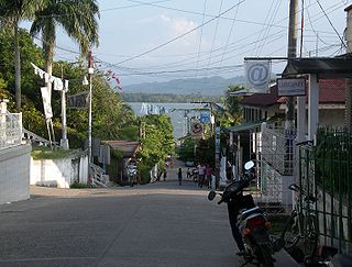
Cobán, fully Santo Domingo de Cobán, is the capital of the department of Alta Verapaz in central Guatemala. It also serves as the administrative center for the surrounding Cobán municipality. It is located 219 km from Guatemala City.

Notes

  1. Thompson 1938, p. 586; ITMB 1998.
  2. Thompson 1938.
  3. 1 2 Thompson 1966, p. 30.
  4. Thompson 1938, pp. 586587; Vos 1980, 1996, p. 75.
  5. 1 2 3 Caso Barrera & Aliphat 2007, p. 53.
  6. Thompson 1966, p. 29; Vos 1980, 1996, p. 75; Caso Barrera & Aliphat 2007, p. 53.
  7. Thompson 1966, p. 29; Caso Barrera & Aliphat 2007, p. 53.

Related Research Articles

Alta Verapaz Department Departments of Guatemala

Alta Verapaz is a department in the north central part of Guatemala. The capital and chief city of the department is Cobán. Verapaz is bordered to the north by El Petén, to the east by Izabal, to the south by Zacapa, El Progreso, and Baja Verapaz, and to the west by El Quiché.

Livingston, Guatemala Place in Izabal Department, Guatemala

Livingston is the name of a town in Izabal Department, eastern Guatemala, at the mouth of the Río Dulce at the Gulf of Honduras. The town serves as the municipal seat of the municipality of the same name. It was Guatemala's main port on the Caribbean Sea before the construction of nearby Puerto Barrios.

El Progreso Department Department in Guastatoya, Guatemala

El Progreso is a department in Guatemala. The departmental capital is Guastatoya. The Spanish established themselves in the region by 1551, after the Spanish conquest of Guatemala. El Progreso was declared a department in 1908, but was dissolved in 1920 before being reestablished in 1934. Guastatoya was badly affected by the 1976 Guatemala earthquake.

The Ch'ol (Chol) language is a member of the western branch of the Mayan language family used by the Ch'ol people in the Mexican state of Chiapas. There are two main dialects:

Rabinal Place in Baja Verapaz, Guatemala

Rabinal is a small town located in the Guatemalan department of Baja Verapaz, at 15°5′4.70″N90°29′20.50″W. It serves as the administrative seat for the surrounding municipality of the same name. The municipality covers 504 km² and, in 2004, had a population of around 36,000. The local people are predominantly Achi Maya Native Americans who speak the Achi Maya language.

Spanish conquest of Guatemala protracted conflict during the Spanish colonization of the Americas, in which Spanish colonisers gradually incorporated the territory that became the modern country of Guatemala into the colonial Viceroyalty of New Spain

The Spanish conquest of Guatemala was a protracted conflict during the Spanish colonization of the Americas, in which Spanish colonisers gradually incorporated the territory that became the modern country of Guatemala into the colonial Viceroyalty of New Spain. Before the conquest, this territory contained a number of competing Mesoamerican kingdoms, the majority of which were Maya. Many conquistadors viewed the Maya as "infidels" who needed to be forcefully converted and pacified, disregarding the achievements of their civilization. The first contact between the Maya and European explorers came in the early 16th century when a Spanish ship sailing from Panama to Santo Domingo was wrecked on the east coast of the Yucatán Peninsula in 1511. Several Spanish expeditions followed in 1517 and 1519, making landfall on various parts of the Yucatán coast. The Spanish conquest of the Maya was a prolonged affair; the Maya kingdoms resisted integration into the Spanish Empire with such tenacity that their defeat took almost two centuries.

Chisec Municipality in Alta Verapaz, Guatemala

Chisec is a municipality in the north of the Guatemalan department of Alta Verapaz that was founded in 1813. It is situated at 230m above sea level. The municipality covers a territory of 1488 km². Approximately 95% of the municipality's inhabitants are Mayan, spread over the town of Chisec and approximately 140 communities. The Q'eqchi' language is widely spoken there alongside Spanish.

Panzós Municipality of Guatemala in Alta Verapaz

Panzós is a municipality in the Guatemalan department of Alta Verapaz.

San Cristóbal Verapaz Place in Alta Verapaz Department, Guatemala

San Cristóbal Verapaz is a municipality in the Guatemalan department of Alta Verapaz. It is at approximately 29 km from Cobán, capital of Alta Verapaz and about 210 km from Guatemala City. San Cristóbal belongs to the Pokimchi' linguistic area. Its main income source is the «Cobán» shoe factory, which specializes in industrial rubber boots, which are sold both locally and internationally.

Roman Catholic Diocese of Verapaz diocese of the Catholic Church

The Roman Catholic Diocese of Verapaz is a Latin suffragan diocese in the ecclesiastical province of the Archdiocese of Guatemala.

Spanish conquest of the Maya

The Spanish conquest of the Maya was a protracted conflict during the Spanish colonisation of the Americas, in which the Spanish conquistadores and their allies gradually incorporated the territory of the Late Postclassic Maya states and polities into the colonial Viceroyalty of New Spain. The Maya occupied a territory that is now incorporated into the modern countries of Mexico, Guatemala, Belize, Honduras and El Salvador; the conquest began in the early 16th century and is generally considered to have ended in 1697.

The Ch'olanAKACholan–Tzeltalan languages are a branch of the Mayan family of Mexico. These languages break into six sections being Cholan and Tzeltalan. Cholan has then two subsections being Western Cholan and Ch'olti'an; these composing the two larger sections of slight linguistic differences portrayed by Kuryłowicz' Fourth Law of Analogy. The language Tzeltalan also breaks up into sections; Tzendal, Tzotzil, and Wastekan. These subsections differ by similar linguistic differences.

Spanish conquest of Petén

The Spanish conquest of Petén was the last stage of the conquest of Guatemala, a prolonged conflict during the Spanish colonisation of the Americas. A wide lowland plain covered with dense rainforest, Petén contains a central drainage basin with a series of lakes and areas of savannah. It is crossed by several ranges of low karstic hills and rises to the south as it nears the Guatemalan Highlands. The conquest of Petén, a region now incorporated into the modern republic of Guatemala, climaxed in 1697 with the capture of Nojpetén, the island capital of the Itza kingdom, by Martín de Ursúa y Arizmendi. With the defeat of the Itza, the last independent and unconquered native kingdom in the Americas fell to European colonisers.

Human sacrifice in Maya culture

During the pre-Columbian era, human sacrifice in Maya culture was the ritual offering of nourishment to the gods. Blood was viewed as a potent source of nourishment for the Maya deities, and the sacrifice of a living creature was a powerful blood offering. By extension, the sacrifice of a human life was the ultimate offering of blood to the gods, and the most important Maya rituals culminated in human sacrifice. Generally only high status prisoners of war were sacrificed, with lower status captives being used for labour.

Salinas de los Nueve Cerros is an archaeological site located in west-central Guatemala. It is the only Precolumbian salt works in the Maya lowlands and one of the longest-occupied sites in Guatemala.

The Spanish conquest of Chiapas was the campaign undertaken by the Spanish conquistadores against the Late Postclassic Mesoamerican polities in the territory that is now incorporated into the modern Mexican state of Chiapas. The region is physically diverse, featuring a number of highland areas, including the Sierra Madre de Chiapas and the Montañas Centrales, a southern littoral plain known as Soconusco and a central depression formed by the drainage of the Grijalva River.

References

Caso Barrera, Laura; Mario Aliphat (2007). J.P. Laporte; B. Arroyo; H. Mejía, eds. "Relaciones de Verapaz y las Tierras Bajas Mayas Centrales en el siglo XVII" (PDF). XX Simposio de Investigaciones Arqueológicas en Guatemala, 2006. Guatemala City, Guatemala: Museo Nacional de Arqueología y Etnología: 48–58. Archived from the original (PDF) on 2013-10-17. Retrieved 2012-01-22. (in Spanish)
Guatemala (Map) (3rd ed.). 1:500000. International Travel Maps. ITMB Publishing Ltd.. 1998. ISBN   0-921463-64-2. OCLC   421536238. 
Thompson, J. Eric S. (October–December 1938). "Sixteenth and Seventeenth Century Reports on the Chol Mayas". American Anthropologist. New Series. Wiley on behalf of the American Anthropological Association. 40 (4 (Part 1)): 584–604. doi:10.1525/aa.1938.40.4.02a00040. JSTOR   661615. (subscription required)
Thompson, J. Eric S. (1966). "The Maya Central Area at the Spanish Conquest and Later: A Problem in Demography". Proceedings of the Royal Anthropological Institute of Great Britain and Ireland. Royal Anthropological Institute of Great Britain and Ireland (1966): 23–37. JSTOR   3031712. (subscription required)
Vos, Jan de (1996) [1980]. La paz de Dios y del Rey: La conquista de la Selva Lacandona (1525–1821). Mexico City, Mexico: Secretaría de Educación y Cultura de Chiapas/Fondo de Cultura Económica. ISBN   968-16-3049-1. OCLC   20747634. (in Spanish)-->