Agivavik, Alaska

Last updated

Agivavik, Alaska
Ghost Town
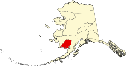
USA Alaska location map.svg
Red pog.svg
Agivavik
Location in the U.S. state of Alaska
Coordinates: 59°22′55″N157°24′13″W / 59.38194°N 157.40361°W / 59.38194; -157.40361
Country United States
State Alaska
Census Area Bethel
Elevation
87 ft (27 m)
Time zone UTC-9 (Alaska (AKST))
  Summer (DST) UTC-8 (AKDT)
Area code 907
GNIS feature ID1893191

Agivavik is a former Inuit settlement and ghost town in Dillingham Census Area, Alaska, United States. It was located on the west bank of the Nushagak River. The site is approximately 6 miles southwest of the city of New Stuyahok and 3 miles northeast of the city of Ekwok. It was initially noted by the Nushagak Russian Orthodox Church vital statistics in 1863 and was visited by a missionary. In 1879, it was noted to have 47 residents. A Father Vasili Shishkin visited the settlement in 1882 and noted it was "one of only three" occupied villages along the river. The 1880 census did not mention the number of homes occupied, though the 1890 census stated there were two (surveyed by A.B. Schanz). [1]

Agivavik would not be mentioned again until noted anthropologist Aleš Hrdlička in his survey of Alaska, visited the site in 1931 and was told by his guide that the village had been abandoned around 1900. Reports and maps had erroneously placed the location of the village on the wrong side of the river or in the wrong location entirely. Orth's Dictionary of Alaska Place Names, which was also referenced by the USGS, also was in error in its location, noting it to be along the "right bank of the Ugashik River." [2]

James Vanstone noted in "Historic Settlement Patterns in the Nushagak River Region" that this settlement had also been occupied in prehistoric times.

Demographics

Historical population
CensusPop.Note
1880 52
1890 30−42.3%
U.S. Decennial Census [3]

Agivavik first appeared on the 1880 U.S. Census as an unincorporated Inuit village with 52 residents, all Inuit. [4] It appeared again on the 1890 census with 30 residents, 2 homes and 6 families (all native). [5] Owing to its abandonment around 1900, it has not appeared again on the census.

Related Research Articles

<span class="mw-page-title-main">Dillingham, Alaska</span> Town in Alaska

Dillingham, also known as Curyung, is a city in Dillingham Census Area, Alaska, United States. Incorporated in 1963, it is an important commercial fishing port on Nushagak Bay. As of the 2020 census, the population of the city was 2,249, down from 2,329 in 2010.

Ekwok is a city in Dillingham Census Area, Alaska, United States. At the 2020 census, the population was 111.

<span class="mw-page-title-main">Koliganek, Alaska</span> Census-designated place in Alaska, United States

Koliganek is a census-designated place (CDP) in Dillingham Census Area, Alaska, United States. It is located along the Nushagak River At the 2010 census, the population was 209, up from 182 in 2000.

Togiak is a city in Dillingham Census Area, Alaska, United States. At the 2010 census the population was 817, up from 809 in 2000.

<span class="mw-page-title-main">Tyonek, Alaska</span> Census-designated place in Alaska, United States

Tyonek or Present / New Tyonek is a census-designated place (CDP) in Kenai Peninsula Borough in the U.S. state of Alaska. As of the 2020 census the population was 152, down from 171 in 2010. In 1973, the community formed the Tyonek Native Corporation (TNC) under the Alaska Native Claims Settlement Act and is federally recognized.

<span class="mw-page-title-main">Ugashik, Alaska</span> Census-designated place in Alaska, United States

Ugashik is a census-designated place (CDP) in Lake and Peninsula Borough, Alaska, United States. The population was 4 at the 2020 census, down from 12 in 2010.

<span class="mw-page-title-main">Golovin, Alaska</span> City in Alaska, United States

Golovin is a city in Nome Census Area, Alaska, United States. At the 2010 census the population was 156, up from 144 in 2000.

<span class="mw-page-title-main">Shaktoolik, Alaska</span> City in Alaska, United States

Shaktoolik is a city in Nome Census Area, Alaska, United States. At the 2010 census the population was 251, up from 230 in 2000. Shaktoolik is one of a number of Alaskan communities threatened by erosion and related global warming effects. The community has been relocated twice.

St. Michael, historically referred to as Saint Michael, is a city in Nome Census Area, Alaska. The population was 401 at the 2010 census, up from 368 in 2000.

<span class="mw-page-title-main">Point Lay, Alaska</span> CDP in Alaska, United States

Point Lay is a census-designated place (CDP) in North Slope Borough, Alaska, United States. At the 2020 census the population was 330, up from 189 in 2010.

<span class="mw-page-title-main">Koyukuk, Alaska</span> City in Alaska, United States

Koyukuk is a city in Yukon-Koyukuk Census Area, Alaska, United States. At the 2010 census the population was 96, down from 101 in 2000.

<span class="mw-page-title-main">Point Barrow</span> Northernmost point of the United States in Alaska

Point Barrow or Nuvuk is a headland on the Arctic coast in the U.S. state of Alaska, 9 miles (14 km) northeast of Utqiagvik. It is the northernmost point of all the territory of the United States, at 71°23′20″N156°28′45″W, 1,122 nautical miles south of the North Pole.

Ohagamiut is an abandoned village along the Kuskokwim River in the Bethel Census Area of the southwestern part of the U.S. state of Alaska, located between Crow Village and Kalskag. It was abandoned in the 1940s as residents relocated to Kalskag, Aniak, Bethel and other towns. The village site is located just 3 miles east of Upper Kalskag.

Crow Village is an unincorporated community on the Kuskokwim River in the U.S. state of Alaska. There are an estimated six residents.

Napaimute is an unincorporated Alaska Native village located in the Bethel Census Area of the U.S. state of Alaska. It is classified as an Alaskan Native Village Statistical Area. As of the 2010 U.S. Census, it has a population of 2. This is up from a population of zero in 2000.

<span class="mw-page-title-main">Nushagak, Alaska</span> Unincorporated community in the state of Alaska, United States

Nushagak was a trade center and settlement near the present-day site of Dillingham, Alaska, United States, at the northern end of Nushagak Bay in northern Bristol Bay. It was located near the confluence of the Wood River and Nushagak Rivers.

<span class="mw-page-title-main">Cape Nome</span>

Cape Nome is a headland on the Seward Peninsula in the U.S. state of Alaska. It is situated on the northern shore of Norton Sound, 15 miles (24 km) to the east of Nome also on Norton Sound. It is delimited by the Norton Sound to the south, Hastings Creek on the west, a lagoon on the east and an estuary formed by the Flambeau River and the Eldorado River. From the sea shore, Cape Nome extends inland by about 4 miles (6.4 km), connected by road with Nome.

<span class="mw-page-title-main">Nuchek, Alaska</span>

Nuchek is an abandoned village in the U.S. state of Alaska. It is located on Hinchinbrook Island at Port Etches bay, Prince William Sound. It is situated approximately 50 miles (80 km) to the west of the mouth of Copper River and 432 miles (695 km) west of Sitka.

Arolik is a former Yup'ik settlement and ghost town in Bethel Census Area, Alaska, United States. It was located at the North mouth of Arolik River adjacent to the shore of Kuskokwim Bay. The site is approximately 4 miles south of the city of Quinhagak. It was first surveyed for the 1880 U.S. Census by Ivan Petroff and reported as "Agaligamute".

Aguikchuk is a former Yup'ik settlement and ghost town in Bethel Census Area, Alaska, United States. It was located on east bank of Kolavinarak River. The site is approximately 10 miles east of the city of Nightmute. It was visited by E. W. Nelson, U.S. Signal Service in December 1878, its name reported by him was "Agiukchugamute," that is, "people of Agiukchuk." It was last noted on the census of 1940, although the U.S. Coast and Geodetic Survey (USC&GS) reported in 1949 that the village was abandoned and the site, often used for a fish camp, is now called "Monrak" or "Monroke." However, the 1954 USGS topographical map of Aguikchuk showed these as two separate places, with the site of "Monrak" being a mile to the north. Present aerial maps show there is nothing left at the site as of 2019, though it is still labeled as Aguikchuk on Google Maps.

References

  1. http://libsysdigi.library.illinois.edu/oca/Books2008-07/historicsettleme61vans/historicsettleme61vans.pdf Historic Settlement Patterns in the Nushagak River Region, Alaska p.42-44
  2. Geological Survey Professional Paper. U.S. Government Printing Office. 1967.
  3. "Census of Population and Housing". Census.gov. Retrieved June 4, 2016.
  4. "Statistics" (PDF). Census.gov. Retrieved October 30, 2019.
  5. Census Office, United States (1893). "Census Reports Eleventh Census: 1890".

59°22′55″N157°24′13″W / 59.38194°N 157.40361°W / 59.38194; -157.40361