Erie County is a highly populated county in the U.S. state of New York. As of the 2010 census, the population was 919,040. The county seat is Buffalo. The county's name comes from Lake Erie. It was named by European colonists for the regional Iroquoian language-speaking Erie tribe of Native Americans, who lived south and east of the lake before 1654.

Cuyahoga Valley National Park is an American national park that preserves and reclaims the rural landscape along the Cuyahoga River between Akron and Cleveland in Northeast Ohio. Cuyahoga Valley is unusual among American national parks being adjacent to two large urban areas and including a dense road network, small towns, and private attractions.

Taughannock Falls State Park is a 750-acre (3.0 km2) state park located in the Town of Ulysses in Tompkins County, New York in the United States. The park is northwest of Ithaca near Trumansburg.

Robert H. Treman State Park is a 1,110-acre (4.5 km2) state park located in Tompkins County, in the Finger Lakes region of New York in the United States. The park is situated in the towns of Ithaca, Enfield and Newfield.
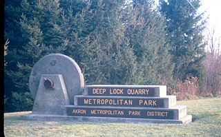
Summit Metro Parks is a Metroparks system serving the citizens of Summit County, Ohio by managing 14,100 acres (5,700 ha) in 16 developed parks, six conservation areas and more than 125 miles (201 km) of trails, with 22.4 miles (36.0 km) of the Ohio & Erie Canal Towpath Trail.
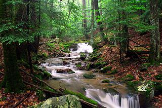
Holly River State Park is a state park located in Webster County, West Virginia. Situated on the Left Fork of the Holly River near the town of Hacker Valley, it is the second largest park in the West Virginia state park system with a total of 8,294 acres (3,356 ha). The park features over 42 miles (68 km) of hiking trails, ten vacation cabins, an 88-unit campground, and many recreation and picnic areas.

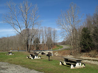
Sgt. Mark A. Rademacher Memorial Park, commonly known as Hunters Creek Park, is a 760-acre (3.1 km2) park located in the Town of Wales in the U.S. state of New York. The park is operated by Erie County Department of Parks, Recreation and Forestry, and is a popular destination for hiking, mountain biking and horseback riding.

Olallie State Park is a public recreation area featuring multiple waterfalls located five miles (8.0 km) southeast of North Bend, Washington. The state park spans a 3.5-mile (5.6 km) stretch along the South Fork of the Snoqualmie River. The most prominent feature of the park is 135-foot-high (41 m) Twin Falls.

Chestnut Ridge Park is a 1,213-acre (4.91 km2) park in Orchard Park, New York, originally named for the chestnut trees on its hills. It is currently the largest park operated by the Erie County Department of Parks, Recreation and Forestry, and is open year-round.
Ellicott Creek Park is a 165-acre (0.67 km2) park in Erie County, in the U.S. state of New York. The park is in the Town of Tonawanda, northeast of Buffalo, New York. The park lies between Tonawanda Creek and Ellicott Creek. Access is free and it is open to the public year-round. It is the smallest multi-purpose park operated by the Erie County Department of Parks, Recreation and Forestry.

Scoby Power Plant and Dam is a historic dam and power plant located between the towns of Ashford and Concord, near Springville, New York. The complex is located on the eastern bank of Cattaraugus Creek outside Springville. It is representative of a small hydroelectric generating facility of the early 20th century in Western New York. The complex was constructed in 1925, replacing a facility near this site.
Southford Falls State Park is a public recreation area covering 126 acres (51 ha) in the towns of Oxford and Southbury, Connecticut. The state park offers fishing, hiking, waterfalls, and a covered bridge over Eight Mile Brook. It is managed by the Connecticut Department of Energy and Environmental Protection.

Grafton Notch State Park is a public recreation area in Grafton Township, Oxford County, Maine. The state park occupies 3,129 acres (1,266 ha) surrounding Grafton Notch, the mountain pass between Old Speck Mountain and Baldpate Mountain. The park is abutted by the eastern and western sections of the Mahoosuc Public Reserved Land, which total 31,807 acres (12,872 ha). The park is managed by the Department of Agriculture, Conservation and Forestry.

Menominee River State Park and Recreation Area is a state park unit of Wisconsin, United States, in development along the Menominee River. It was created in 2010 in conjunction with the Menominee River State Recreation Area on the Michigan side of the border river. The Wisconsin park is located in the towns of Niagara, Pembine, and Beecher in Marinette County in northeast Wisconsin. The 6,563-acre (2,656 ha) park comprises an undeveloped northern unit and a southern portion with primitive hiking trails and canoe/walk-in campsites.
Sprague Brook Park is a 974-acre (3.94 km2) county park in the hamlet of Glenwood in Erie County, New York. It is operated by the Erie County Department of Parks, Recreation and Forestry, and it is the only park managed by Erie County that offers overnight camping facilities. Access to the park is free and it is open year-round.
Emery Park is a 490-acre (2.0 km2) park in Erie County, in the U.S. state of New York. The park is located in the hamlet of South Wales, southeast of the city of Buffalo. It is operated by the Erie County Department of Parks, Recreation and Forestry. Access is free and it is open to the public year-round.
Como Lake Park is a 534-acre (2.16 km2) park in Erie County, in the U.S. state of New York. The park is located along the banks of Cayuga Creek in both the village and town of Lancaster, approximately 14 miles (23 km) east of the city of Buffalo. It is operated by the Erie County Department of Parks, Recreation and Forestry. Access is free and it is open to the public year-round.

Wendt Beach Park is a 178-acre (72-hectare) waterfront park in Erie County, in the U.S. state of New York. The park is located along the shore of Lake Erie in the Town of Evans. It is operated by the Erie County Department of Parks, Recreation and Forestry. Access is free and it is open to the public year-round.

Beechwood State Park is a 288-acre (1.17 km2) state park located on the shore of Lake Ontario in the Town of Sodus in Wayne County, New York. The park occupies land that was formerly the site of a Girl Scout camp. The park is owned by the New York State Office of Parks, Recreation and Historic Preservation and is currently operated by the Town of Sodus under an agreement with New York State.
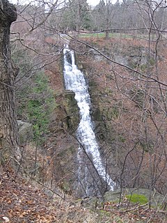
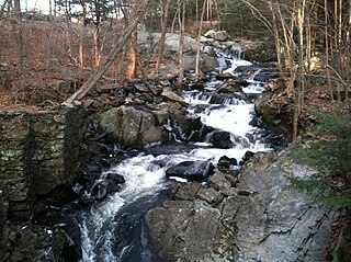
Pratt's Falls Park is a county park in Pompey, New York, United States. This park officially opened to the public on July 3, 1934. It contains Pratt's Falls, a 137 ft (42 m) ribbon or cascade style waterfall, two covered shelters, an enclosed pavilion known as Camp Brockway, three hiking trails, two archery facilities, an archery course, picnic areas, and a playground. Pratt's Falls park is part of the Onondaga County Parks system.