Eighteen Mile Creek (Erie County)

Last updated
Eighteen Mile Creek
Eighteen Mile Creek Hamburg.jpg
Eighteen Mile Creek in Hamburg, New York.
USA New York relief location map.svg
Red pog.svg
Location of the mouth of Eighteen Mile Creek in New York State.
Usa edcp relief location map.png
Red pog.svg
Eighteen Mile Creek (Erie County) (the United States)
Location
Country United States
State New York
Region Western New York
County Erie County
Physical characteristics
Source 
  location Concord
  coordinates 42°33′23″N78°41′28″W / 42.55639°N 78.69111°W / 42.55639; -78.69111 [1]
2nd sourceSouth Branch Eighteen Mile Cr.
  location North Collins
  coordinates 42°32′17″N78°45′51″W / 42.53806°N 78.76417°W / 42.53806; -78.76417 [2]
Source confluence 
  location Hamburg
  coordinates 42°41′58″N78°54′12″W / 42.69944°N 78.90333°W / 42.69944; -78.90333 [2]
Mouth Lake Erie
  location
Highland-on-the-Lake
  coordinates
42°43′05″N78°58′09″W / 42.71806°N 78.96917°W / 42.71806; -78.96917 [1]
Basin size310 km2 (120 sq mi)
Basin features
Tributaries 
  rightSouth Branch Eighteen Mile Cr.

Eighteen Mile Creek (also known as Eighteenmile Creek) is a tributary of Lake Erie located in southern Erie County, New York, United States. [1] The creek is the second largest tributary of Lake Erie in New York State. [3]

Contents

The name is derived from the creek's distance south of the Niagara River in Buffalo. The creek was named Koughquaugu Creek by the Seneca Nation. [4]

Course

From its source in the town of Concord, [1] Eighteen Mile Creek flows north and then west before entering Lake Erie at the community of Highland-on-the-Lake in the town of Evans. [3] It has one major tributary, the South Branch Eighteen Mile Creek, which joins the main branch within Eighteen Mile Creek Park in the town of Hamburg. [2] [5] The creek drains an approximately 120-square-mile (310 km2) watershed. [3]

Geology

The lower section of Eighteen Mile Creek has been known for its abundance of fossils since the 19th century. [6] The faces of the creek's gorges expose bands of shale overlain by limestone which yield numerous fossils dating from the middle to late Devonian Period. These include corals such as Heliophyllum and Favosites in addition to various species of crinoids, brachiopods, bryozoans, bivalves, and trilobites. [7] [8]

Portions of the creek and surrounding area in the town of Hamburg have been designated as a "Critical Environmental Area" due to its abundance of fossils. [9]

Public use

Sportfishing

Eighteen Mile Creek is utilized by anglers seeking Lake Erie steelhead during their annual spawning runs that take place from mid-October to early May. Brown trout are also sought year-round. Fishing access is facilitated by 1.4 miles (2.3 km) of "public fishing rights" conservation easements secured along the creek and its major tributary, the creek's South Branch. An additional 2.5 miles (4.0 km) of stream access is available within Eighteen Mile Creek County Park; the portion located along the main stem within the park is a catch and release area where only artificial lures are permitted. [5]

Eighteen Mile Creek is stocked annually by the New York State Department of Environmental Conservation. In 2014, 20,000 steelhead and 660 brown trout were stocked in the stream, and an additional 20,000 steelhead were stocked in the creek's South Branch. [10]

Parks and forests

Eighteen Mile Creek Park, a 464-acre (1.88 km2) county park, is located at the confluence of Eighteen Mile Creek's main stem and its South Branch in the town of Hamburg. The park is largely undeveloped with the exception of hiking trails and a small parking area. It is managed by the Erie County Department of Parks, Recreation and Forestry and includes a 60-foot (18 m) gorge along the creek. [11] A small parking lot on South Creek Road provides access to five miles (8.0 km) of hiking trails, as well as access for fishing along the creek. [12]

In November 2015, the Erie County Parks Department announced that a 225-acre (0.91 km2) forested parcel at the headwaters of Eighteen Mile Creek had been purchased by the county in order to prevent commercial development. [13] The acquisition took place in collaboration with The Nature Conservancy and the Buffalo Niagara Riverkeeper, who together with the county aimed to raise $320,000 for the purchase. [14] The newly purchased forest in the town of Concord joins other county lands protecting the creek's headwaters, helping to provide habitat for fish and wildlife in addition to improving drinking water quality within the region. Over 1,000 acres (4.0 km2; 1.6 sq mi) of land near the creek's headwaters are protected by the county, and are accessible to the public for passive recreation such as hiking. [15]

See also

Related Research Articles

<span class="mw-page-title-main">Erie County, New York</span> County in New York, United States

Erie County is a county along the shore of Lake Erie in western New York State. As of the 2020 census, the population was 954,236. The county seat is Buffalo, which makes up about 28% of the county's population. Both the county and Lake Erie were named for the regional Iroquoian language-speaking Erie tribe of Native Americans, who lived in the area before 1654. They were later pushed out by the more powerful Iroquoian nations tribes.

<span class="mw-page-title-main">Mohawk River</span> River in the U.S. state of New York

The Mohawk River is a 149-mile-long (240 km) river in the U.S. state of New York. It is the largest tributary of the Hudson River. The Mohawk flows into the Hudson in Cohoes, New York, a few miles north of the state capital of Albany. The river is named for the Mohawk Nation of the Iroquois Confederacy. A major waterway, in the early 19th century, the river's east-west valley provided the setting and water for development of the Erie Canal, as a key to developing New York. The largest tributary, the Schoharie Creek, accounts for over one quarter (26.83%) of the Mohawk River's watershed. Another main tributary is the West Canada Creek, which makes up for 16.33% of the Mohawk's watershed.

Lake Erie State Park is a 355-acre (1.44 km2) state park located in the Town of Portland in Chautauqua County, New York, United States, northeast of the village of Brocton. Its major attraction is its Lake Erie beach, in addition to its campsites and other recreational facilities.

<span class="mw-page-title-main">Buttermilk Falls State Park</span> State park in New York state, United States

Buttermilk Falls State Park is a 811-acre (3.28 km2) state park located southwest of Ithaca, New York, United States. Like Robert H. Treman State Park, a portion of the land that was to become the state park came from Robert and Laura Treman in 1924.

<span class="mw-page-title-main">Cattaraugus Creek</span> River in New York, United States

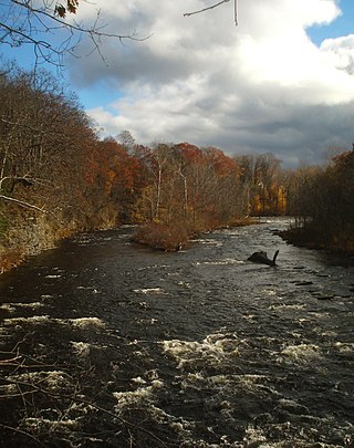
Cattaraugus Creek is a stream, approximately 68 miles (109 km) long, in western New York in the United States. The creek drains a wooded rural portion of western New York southwest of Buffalo into Lake Erie. In its lower course it flows primarily through the Cattaraugus Reservation of the Seneca tribe. William Beauchamp identifies the name Cattaraugus as deriving from the Seneca word Gah-ta-ra-ke-ras, meaning "stinking shore" or "foul-smelling river bank." This in turn is likely a loanword from an extinct Attiwandiron, Erie, Wenro, or Wendat (Huron) language, combining the verb root -i'tar-, referring to clay or mud, and -akera(n)-, describing a bad or strong odor: hence, tke'tarakeras, place of strong-smelling mud or clay. This name is a result of the natural gas that oozes from the river mud.

<span class="mw-page-title-main">Seneca River (New York)</span> River in Upstate New York

The Seneca River flows 61.6 miles (99.1 km) through the Finger Lakes region of Upstate New York in the United States. The main tributary of the Oswego River – the second-largest river flowing into Lake Ontario – the Seneca drains 3,468 square miles (8,980 km2) in parts of fourteen New York counties. The Seneca flows generally east, and is wide and deep with a gentle gradient. Much of the river has been channelized to form part of the Erie Canal.

<span class="mw-page-title-main">Salmon River (New York)</span> River in the United States

The Salmon River is a small river north of Syracuse in Upstate New York, the United States. It is a popular and economically important sportfishing destination, and the most heavily fished of New York's Lake Ontario tributaries. From its headwaters in the Tug Hill region of New York, it flows 44 miles (71 km) westward through two hydroelectric dams and over the 110-foot (34 m) Salmon River Falls before it empties into eastern Lake Ontario at Port Ontario in Oswego County. The Salmon River watershed drains approximately 280 square miles (730 km2).

Cherry Plain State Park is a 175-acre (0.71 km2) state park located in Rensselaer County, New York in the United States. The park is located in Cherry Plain at the southwest part of the Town of Berlin, near the Massachusetts border. Outdoor recreational opportunities are also available within the Capital District Wildlife Management Area, a 4,153-acre (16.81 km2) conservation area that nearly surrounds the park.

Catharine Creek is a roughly 15-mile-long (24 km) stream that flows through Chemung and Schuyler counties in New York. The creek, named after Catharine Montour, is a major tributary to Seneca Lake.

<span class="mw-page-title-main">Oquaga Creek State Park</span> State park in New York, United States

Oquaga Creek State Park is a 1,385-acre (5.60 km2) state park in Broome, Delaware, and Chenango counties, New York. The park is partially in the Town of Masonville and partly in the Town of Sanford. Broome County Road 241 passes through the park.

Big Six Mile Creek Marina is a 21-acre (0.085 km2) state park and marina located on the upper Niagara River on Grand Island in Erie County, New York.

Lake Taghkanic State Park is a 1,569-acre (6.35 km2) state park located in the southern part of Columbia County, New York in the United States. The park is on the town line between the towns of Gallatin and Taghkanic, and is adjacent to the Taconic State Parkway.

<span class="mw-page-title-main">Zoar Valley</span>

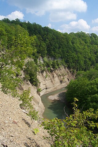
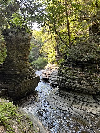
Zoar Valley is an area of deep gorges along the Main and South branches of Cattaraugus Creek in western New York, United States. The valley is located along the border of Erie County and Cattaraugus County, roughly between the villages of Gowanda to the west and Springville to the east.

Eighteen Mile Creek, or Eighteenmile Creek, is a tributary of Lake Ontario located entirely in Niagara County, New York in the United States. The name of "Eighteen Mile" Creek refers not to the length of the creek, but to its distance from the Niagara River to the west.

<span class="mw-page-title-main">Chautauqua Creek</span> River in New York, United States

Chautauqua Creek is a tributary of Lake Erie, approximately 15 miles (24 km) long, in the southwestern corner of New York in the United States. The headwaters of the creek rise in the town of Sherman, in Chautauqua County, and flow in a northerly direction through the town and village of Westfield where they empty into Lake Erie. For much of its length, the creek serves as the boundary line between the towns of Westfield and Chautauqua.

<span class="mw-page-title-main">Moose River Plains Wild Forest</span>

The Moose River Plains Wild Forest is a 64,322-acre tract in the Adirondack Park in Hamilton and Herkimer counties in the state of New York in the United States of America; it is designated as Wild Forest by the New York State Department of Environmental Conservation.

<span class="mw-page-title-main">Scoby Power Plant and Dam</span> Historic dam and power plant in New York State

Scoby Power Plant and Dam is a historic dam and now defunct power plant located between the towns of Ashford and Concord, near Springville, New York. The complex is located on the eastern bank of Cattaraugus Creek outside Springville. It is representative of a small hydroelectric generating facility of the early 20th century in Western New York. The complex was constructed in 1925, replacing a facility near this site.

<span class="mw-page-title-main">South Sandy Creek</span> River in New York, United States

South Sandy Creek is a small tributary to Lake Ontario in Jefferson and Lewis counties in the U.S. state of New York. South Sandy Creek flows from its source in the Tug Hill region westward through the village of Ellisburg before emptying into Lake Ontario.

<span class="mw-page-title-main">Butternut Creek (Limestone Creek tributary)</span> River in New York, United States

Butternut Creek is a stream in the greater Syracuse, New York area and a tributary of Limestone Creek, part of the Oneida Lake watershed. The creek is about 16 miles (26 km) long.

The Little Salmon River is a tributary of Lake Ontario located in Oswego County, New York. The river enters Lake Ontario approximately four miles (6.4 km) southwest from the mouth of the Salmon River.

References

  1. 1 2 3 4 "Eighteenmile Creek". Geographic Names Information System . United States Geological Survey, United States Department of the Interior . Retrieved December 11, 2015.
  2. 1 2 3 "South Branch Eighteenmile Creek". Geographic Names Information System . United States Geological Survey, United States Department of the Interior . Retrieved December 15, 2015.
  3. 1 2 3 "Coastal Fish & Wildlife Habitat Rating Form - Eighteen Mile Creek - Lake Erie" (PDF). Dos.ny.gov. New York State Department of State. October 15, 1987. Archived from the original (PDF) on December 22, 2015. Retrieved December 15, 2015.
  4. Beauchamp, William Martin (1907). Aboriginal Place Names of New York (New York State Museum Bulletin, Volume 108). New York State Education Department. p. 64. ISBN   9781404751552 . Retrieved December 11, 2015.
  5. 1 2 "Public Fishing Information for Eighteen Mile Creek" (PDF). Dec.ny.gov. NYS Department of Environmental Conservation. Retrieved December 13, 2015.
  6. Amadeus William, Grabau (1898). Geology and Palaeontology of Eighteen Mile Creek and the Lake Shore Sections of Erie County, New York: A Handbook for the Use of Students and Amateurs (Bulletin of the Buffalo Society of Natural Sciences, Volume 6). Buffalo Society of Natural Sciences. Retrieved December 14, 2015.
  7. Maletz, Jörg. "Devonian Stratigraphy and Fossil Assemblages of WNY". Buffalo.edu. Retrieved December 14, 2015.
  8. Ball, Jessica (March 18, 2012). "Fossil interlude: Eighteen Mile Creek, New York". Blogs.AGU.org. American Geophysical Union. Retrieved December 15, 2015.
  9. "Mouth of Eighteen Mile Creek at Lake Erie". Dec.ny.gov. NYS Department of Environmental Conservation. Retrieved December 14, 2015.; Map of the Critical Environmental Area
  10. "2014 Fish Stocking in Erie County". Dec.ny.gov. NYS Department of Environmental Conservation. Archived from the original on October 5, 2015. Retrieved December 14, 2015.
  11. "Eighteen Mile Creek". Erie.gov. Erie County Department of Parks, Recreation and Forestry. Retrieved December 14, 2015.
  12. "Erie County's 18 Mile Creek Park for Hiking, Snowshoeing, and Mountain Biking". WNYtrails.com. WNY Trails. Retrieved December 14, 2015.
  13. "Eighteen Mile Creek headwaters now under county control". WGRZ.com. November 20, 2015. Retrieved December 14, 2015.[ permanent dead link ]
  14. "Eighteenmile Creek headwaters to be protected". Nature.org. The Nature Conservancy. Archived from the original on December 22, 2015. Retrieved December 15, 2015.
  15. "Erie County Parks, Partners Collaborate to Protect, Preserve Concord Land Parcel". Erie.gov. Erie County Executive's Office. November 20, 2015. Retrieved December 14, 2015.