Albany County Helderberg-Hudson Rail Trail

Last updated
Albany County Helderberg-Hudson Rail Trail
Length9.8 miles (15.8 km)
Location Albany County, New York
Trailheads Albany, Delmar, Slingerlands, Voorheesville
UseBiking, inline skating, walking, cross-country skiing
DifficultyFairly easy, level, ADA-accessible
SeasonAll year, dawn to dusk
Surface Asphalt
Right of way Albany and Susquehanna Railroad
Website https://www.albanycounty.com/departments/recreation/albany-county-helderberg-hudson-rail-trail

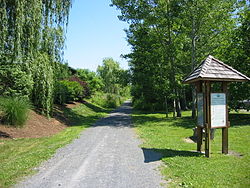
The Albany County Helderberg-Hudson Rail Trail is a 9.8 mile rail trail in Albany County, New York. [1] Starting in the South End of the city of Albany, it connects to the communities of Delmar and Slingerlands before ending in the village of Voorheesville. In Albany, the trail directly connects to the South End Bikeway, which connects to Downtown Albany and the Mohawk-Hudson Bike-Hike Trail - a part of both the Erie Canalway Trail and Empire State Trail systems.

The trail was first announced in 2010, with the section from Delmar to Slingerlands built using stone dust the following year. The section from Albany to Slingerlands was paved in 2016, and the paving was extended to Voorheesville in 2018. By the end of 2018, the trail was complete. [2]

The Albany County Rail Trail has become a popular trail in the Capital Region. In 2016, approximately 164,000 people used the trail in Delmar - this was right after that segment was paved but before being completed out to Voorheesville. In the Capital Region, this number is only bested by the Mohawk-Hudson Bike-Hike Trail. [3]

The trail is owned, operated, and maintained by the Albany County government.

Related Research Articles

<span class="mw-page-title-main">Albany County, New York</span> County in New York, United States

Albany County is a county in the state of New York, United States. Its northern border is formed by the Mohawk River, at its confluence with the Hudson River, which is to the east. As of the 2020 United States Census, the population was 314,848. The county seat and largest city is Albany, which is also the state capital of New York. As originally established by the English government in the colonial era, Albany County had an indefinite amount of land, but has had an area of 530 square miles (1,400 km2) since March 3, 1888. The county is named for the Duke of York and of Albany, who became James II of England.

<span class="mw-page-title-main">Bethlehem, New York</span> Town in New York, United States

Bethlehem is a town in Albany County, New York, United States. The town's population was 35,034 at the 2020 census. Bethlehem is located immediately to the south of the City of Albany. Bethlehem includes the following hamlets: Delmar, Elsmere, Glenmont, North Bethlehem, Selkirk, Slingerlands, and South Bethlehem. U.S. Route 9W passes through the town. The town is named after the biblical Bethlehem.

<span class="mw-page-title-main">Voorheesville, New York</span> Village in New York, United States

Voorheesville is a village within the town of New Scotland in Albany County, New York, United States. It is a suburb of Albany and part of the city's historic metropolitan area. The population was 2,789 at the 2010 census. The village is named after a railroad attorney, Alonzo B. Voorhees.

<span class="mw-page-title-main">New York State Route 32</span> North-south highway in New Yorks Hudson Valley

New York State Route 32 (NY 32) is a north–south state highway that extends for 176.73 miles (284.42 km) through the Hudson Valley and Capital District regions of the U.S. state of New York. It is a two-lane surface road for nearly its entire length, with few divided and no limited-access sections. From Harriman to Albany, it is closely parallel to Interstate 87 (I-87) and U.S. Route 9W (US 9W), overlapping with the latter in several places.

<span class="mw-page-title-main">Delaware and Hudson Railway</span> Railroad in the northeastern United States

The Delaware and Hudson Railway (D&H) is a railroad that operates in the Northeastern United States. In 1991, after more than 150 years as an independent railroad, the D&H was purchased by the Canadian Pacific Railway (CP). CP operates D&H under its subsidiary Soo Line Corporation which also operates Soo Line Railroad.

<span class="mw-page-title-main">Long Path</span> Hiking trail from George Washington Bridge to Mohawk River valley in upstate New York

The Long Path is a 357-mile (575 km) long-distance hiking trail beginning in New York City, at the West 175th Street subway station near the George Washington Bridge and ending at Altamont, New York, in the Albany area. While not yet a continuous trail, relying on road walks in some areas, it nevertheless takes in many of the popular hiking attractions west of the Hudson River, such as the New Jersey Palisades, Harriman State Park, the Shawangunk Ridge and the Catskill Mountains. It offers hikers a diversity of environments to pass through, from suburbia and sea-level salt marshes along the Hudson to wilderness and boreal forest on Catskill summits 4,000 feet (1,220 m) in elevation.

<span class="mw-page-title-main">John Boyd Thacher State Park</span>

John Boyd Thacher State Park is a state park located 15 miles (24 km) southwest of Albany, New York, near Voorheesville, in Albany County on State Route 157. Located mostly atop the Helderberg Escarpment, the park has several hiking trails that offer panoramic views of the Green Mountains in Vermont and the Taconic Mountains of the Hudson Valley.

<span class="mw-page-title-main">Area codes 518 and 838</span> Telephone area codes for Upstate New York, US

Area codes 518 and 838 are telephone area codes serving the northeasternmost part of Upstate New York in the United States. 518 was established as one of the original area codes during 1947. Area code 838 was added as an overlay during 2017. The two area codes cover 24 counties and 1,200 ZIP Codes. There are 493 landline exchanges and 100 wireless exchanges served by 47 carriers. The numbering plan area (NPA) it covers in New York State extends from the eastern Mohawk Valley to the Vermont border, and from the Canada–US border to south of Albany. The bulk of this NPA population is in the Capital District. Other cities in the NPA are Glens Falls, Plattsburgh, and Saratoga Springs.

Crescent Station is a hamlet of the town of Colonie in Albany County, New York, United States that straddles US Route 9.

<span class="mw-page-title-main">New York State Route 85</span>

New York State Route 85 (NY 85) is a state highway in Albany County, New York, in the United States. It is 26.49 miles (42.63 km) in length and runs from CR 353 in Rensselaerville to Interstate 90 (I-90) exit 4 in Albany. It also has a loop route, NY 85A, which connects NY 85 to the village of Voorheesville. The portion of NY 85 north of NY 140 to the Bethlehem–Albany town/city line is known as the Slingerlands Bypass. From there north to I-90, the road is a limited-access, four-lane highway named the Crosstown Arterial.

<span class="mw-page-title-main">New York State Route 443</span>

New York State Route 443 (NY 443) is an east–west state highway in the Capital District of New York in the United States. The route begins at an intersection with NY 30 in the town of Schoharie and ends 33.44 miles (53.82 km) later at a junction with U.S. Route 9W (US 9W) and US 20 in the city of Albany. It ascends the Helderberg Escarpment in the towns of Berne and New Scotland. Within the town of Bethlehem and the city of Albany, NY 443 is known as Delaware Avenue.

<span class="mw-page-title-main">Wallkill Valley Rail Trail</span> Rail Trail in the Wallkill Valley

The Wallkill Valley Rail Trail is a 22.5-mile (36.2 km) rail trail and linear park that runs along the former Wallkill Valley Railroad rail corridor in Ulster County, New York. It stretches from Gardiner through New Paltz, Rosendale and Ulster to the Kingston city line, just south of a demolished, concrete Conrail railroad bridge that was located on a team-track siding several blocks south of the also-demolished Kingston New York Central Railroad passenger station. The trail is separated from the Walden–Wallkill Rail Trail by two state prisons in Shawangunk, though there have been plans to bypass these facilities and to connect the Wallkill Valley Rail Trail with other regional rail-trails. The northern section of the trail forms part of the Empire State Trail.

<span class="mw-page-title-main">Mohawk-Hudson Bike-Hike Trail</span>

The Mohawk-Hudson Bike-Hike Trail (MHBHT) is a 97-mile (156 km) trail in New York's Mohawk Valley and Capital District regions. It is also the easternmost segment of the Erie Canalway Trail, as well as a portion of the Empire State Trail.

Clarksville is a hamlet in the town of New Scotland, Albany County, New York, United States. It is situated along Delaware Turnpike in the southern part of the town at the foot of the Helderberg Escarpment. It is the site of the Clarksville Cave and has an annual Clarksville Heritage Day and Car Show. It is in the Onesquethaw Volunteer Fire Company fire protection district.

Van Schaick Island is an island in the city of Cohoes, New York. Van Schaick is a part of the delta of the Mohawk River at its mouth with the Hudson River. The island has been referred to by numerous names including Quehemesicos, Long, Anthony's, Isle of Cohoes, and Cohoes Island. The island was home to US Revolutionary War fortifications in the 18th century, and to an important shipyard in the 20th century. The shipyard and the extreme northern end of the island is part of the Peebles Island State Park, and the only vehicular entrance to the state park is on the island.

<span class="mw-page-title-main">Niska Isle</span>

Niska Isle, despite its name, is not an island, but a peninsula in the town of Niskayuna, New York. Niska Isle is along the Mohawk River's south shore, with a back bay and swamp that surrounds it to the south.

<span class="mw-page-title-main">Onesquethaw Creek</span> River in New York, United States

Onesquethaw Creek is a 14.5-mile-long (23.3 km) creek in Albany County, New York. It is a tributary of the Hudson River. It rises in the town of New Scotland, to the west of the hamlet of New Salem, in the Helderberg Mountains, and flows to Coeymans Creek in the town of Bethlehem, southwest of Delmar.

<span class="mw-page-title-main">Empire State Trail</span>

The Empire State Trail is a multi-use trail in New York State that was proposed by Governor Andrew Cuomo in January 2017 and completed in December 2020. The trail runs from Manhattan north to the Canadian border in Rouses Point near the northern tip of Lake Champlain, and also from Buffalo to Albany. At 750 miles (1,210 km), it is the longest multi-use trail in the United States. The trail includes pre-existing trail segments, which retain their existing identity but are now co-signed as a segment of the Empire State Trail. The trail also links to other regional bicycling and hiking trails such as the Appalachian Trail, the Adirondack and Catskill Parks, the Great Lakes Seaway Trail, the Genesee Valley Greenway, and others. A segment near its southernmost part, on the Hudson River Greenway in Manhattan, is concurrent with the East Coast Greenway. The trail is used for hiking, biking, snowshoeing, cross-country skiing and in some areas snowmobiling.

References

  1. "Albany County Helderberg-Hudson Rail Trail". Albany, New York: Albany County. 2019.
  2. "Rail Trail Updates". Albany, New York: Albany County. 2019.
  3. "Capital District Multi-Use Trail User Counts" (PDF). Albany, New York: Capital District Transportation Committee. 2017.