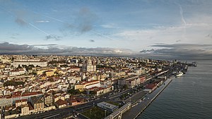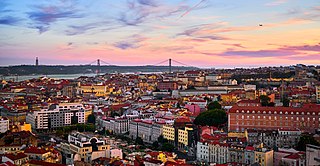
Lisbon is the capital and largest city of Portugal, with an estimated population of 567,131 as of 2023 within its administrative limits and 2,961,177 within the metropolis. Lisbon is mainland Europe's westernmost capital city and the only one along the Atlantic coast, the others being on islands. The city lies in the western portion of the Iberian Peninsula, on the northern shore of the River Tagus. The western portion of its metro area, the Portuguese Riviera, hosts the westernmost point of Continental Europe, culminating at Cabo da Roca.

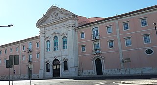
Sacavém is a city and former civil parish in the municipality of Loures, Lisbon District, Portugal. In 2013, the parish merged into the new parish Sacavém e Prior Velho. It is a few kilometers north-east of the Portuguese capital, Lisbon. The civil parish covers an area of 4.09 km2 (1.6 sq mi), and included as of 2001 census a resident population of 17,659 inhabitants. The region is known for its famous ceramics industry.
Bairro Alto is a central district of the city of Lisbon, the Portuguese capital. Unlike many of the civil parishes of Lisbon, this region can be commonly explained as a loose association of neighbourhoods, with no formal local political authority but social and historical significance to the urban community of Lisbon and of Portugal as a whole.

São Jorge Castle, sometimes known in English as Saint George's Castle, is a historic castle in the Portuguese capital of Lisbon, located in the freguesia of Santa Maria Maior. Human occupation of the castle hill dates to at least the 8th century BC while the oldest fortifications on the site date from the 2nd century BC. The hill on which Saint George's Castle stands has played an important part in the history of Lisbon, having served as the location of fortifications occupied successively by Phoenicians, Carthaginians, Romans, and Moors, before its conquest by the Portuguese in the 1147 Siege of Lisbon. Since the 12th century, the castle has variously served as a royal palace, a military barracks, home of the Torre do Tombo National Archive, and now as a national monument and museum.

Alvalade is a freguesia and typical quarter of Lisbon, the capital city of Portugal. Located in central Lisbon, Alvalade is south of Lumiar and Olivais, west of Marvila, east of São Domingos de Benfica, and north of Avenidas Novas and Areeiro. The population in 2021 was 33,309.

Castle of Braga is a historical fortification and defensive line encircling the city of Braga. While, in fact, the only remains of this structure are the various gates and towers along its perimeter, the main keep tower, located in the civil parish of São João do Souto, is the only true remnant of the medieval castle.

Olivais is a freguesia and typical quarter of Lisbon, the capital city of Portugal. Located in eastern Lisbon, Olivais is west of Parque das Nações, north of Marvila and Alvalade, and east of Lumiar and Santa Clara. The population in 2021 was 32,179.
Lumiar is a freguesia and typical quarter of Lisbon, the capital city of Portugal. Located in northern Lisbon, Lumiar is east of Carnide, north of Alvalade, west of Olivais, and south of Santa Clara and partially of Lisbon's border with Odivelas. The population in 2021 was 46,334.

The Casa dos Bicos is a historical house in the civil parish of Santa Maria Maior, in the Portuguese municipality of Lisbon. The house, built in the early 16th century in the Alfama neighbourhood, has a curious façade of spikes, influenced by Italian Renaissance palaces and Portuguese Manueline styles. It survived the disastrous 1755 Lisbon earthquake that destroyed much of the city, but over time was abandoned as a residence and used as a warehouse. After a 20th-century renovation, it became the headquarters of the José Saramago Foundation and a location of the Museum of Lisbon.
Beato is a freguesia and typical quarter of Lisbon, the capital city of Portugal. Located in eastern Lisbon, Beato is south of Marvila and Areeiro, and west of Penha de França. The population in 2021 was 12,183.

Carnide is a freguesia and typical quarter of Lisbon, the capital city of Portugal. Located in northern Lisbon, Carnide is north of São Domingos de Benfica and Benfica, east of Lumiar, and directly south of Lisbon's border with Odivelas. The population in 2021 was 18,028.
Penha de França is a freguesia and typical quarter of Lisbon, the capital city of Portugal. Located in the historic center of Lisbon, Penha de França is north of São Vicente, east of Arroios, south of Areeiro, and west of Beato. The population in 2021 was 28,475.

The Lisbon tramway network is a system of trams that serves Lisbon, the capital city of Portugal. In operation since 1873, it presently comprises six lines. The system has a length of 31 km, and 63 trams in operation. The depot is located in Santo Amaro, in Alcântara.
Nossa Senhora do Bispo is a former civil parish in the municipality of Montemor-o-Novo, Portugal. In 2013, the parish merged into the new parish Nossa Senhora da Vila, Nossa Senhora do Bispo e Silveiras. It has an area of 121.83 km2, and a population of approximately 5411 inhabitants in 2001. It contains the localities Fazendas do Cortiço, Ferro da Agulha and São Geraldo.

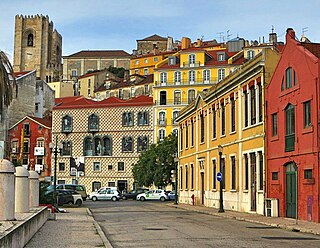
Santa Maria Maior is a freguesia and district of Lisbon, the capital of Portugal. Located in the historic center of Lisbon, Santa Maria Maior is to the west of São Vicente, east of Misericórdia, and south of Arroios and Santo António. It is home to numerous historic monuments, including Lisbon Cathedral, the Rossio, and the Praça do Comércio, as well as famous neighborhoods, such as the Lisbon Baixa, as well as parts of Bairro Alto and Alfama. The population in 2011 was 12,822,

Santa Clara is a freguesia and typical quarter of Lisbon, the capital city of Portugal. Located in northern Lisbon, Santa Clara is north of Lumiar, west of Olivais, and directly south of Lisbon's border with Odivelas and Loures. The population in 2021 was 23,645.

São Vicente is a freguesia and district of Lisbon, the capital of Portugal. Located in the historic center of Lisbon, São Vicente is to the east of Santa Maria Maior, south of Arroios, and west of Penha de França. São Vicente is home to numerous historic neighborhoods, including Alfama. The population in 2021 was 13,956, for a population density of 7,013.1 inhabitants per km2 on an area of 1.99 square kilometers
Lisbon is one of the most popular city destinations in Europe. The city of Lisbon and the Lisbon metropolitan area attracts a significant number of tourists each year, drawn to its historical and cultural heritage, good transportation connections and good touristic infrastructure.

The Pillory of Lisbon is a pillory situated in the municipal square of the Portuguese capital, classified as a National Monument.

The walls of Lisbon are a series of three nested defensive stone-wall complexes built at different times to defend Lisbon. They consist of the São Jorge Castle proper and its walls the Cerca Moura, its lateral extension the Muralha de D. Dinis, and the Cerca Fernandina. If it was remade into a 1 m high wall, the masonry in the Cerca Fernandina would stretch from Lisbon to Porto, approximately.