Allen, South Dakota

Last updated

Allen, South Dakota
CDP
Allen, South Dakota.jpg
Bennett County South Dakota Incorporated and Unincorporated areas Allen Highlighted.svg
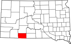
Location in Bennett County and the state of South Dakota
Usa edcp location map.svg
Red pog.svg
Allen, South Dakota
Location of Allen
North America laea location map.svg
Red pog.svg
Allen, South Dakota
Allen, South Dakota (North America)
Coordinates: 43°16′45″N101°55′35″W / 43.27917°N 101.92639°W / 43.27917; -101.92639 [1]
Country United States
state South Dakota
Counties Bennett
Civil township Allen Township
Area
  Total
3.9 sq mi (10 km2)
  Land3.9 sq mi (10 km2)
  Water0 sq mi (0 km2)  0%
Elevation
[2]
3,297 ft (1,005 m)
Population
 (2020)
  Total
460
  Density107.7/sq mi (41.6/km2)
Time zone UTC-7 (Mountain (MST))
  Summer (DST) UTC-6 (MDT)
ZIP code
57714
GNIS feature ID2393315 [2]

Allen is a census-designated place on the Pine Ridge Indian Reservation in Bennett County, South Dakota, United States, that was named for the Allen Township (civil township), [3] which it encompasses. As of the 2020 census, the CDP had a population of 460. [4] It is one of two places which are closest to the North American continental pole of inaccessibility.

Contents

History

The CDP is named for the Allen Township, which in turn was named for Charles W. Allen, the town's first merchant. [5]

Geography

According to the United States Census Bureau, the CDP has a total area of 3.9 square miles (10 km2), all land.

Allen has been assigned the ZIP code 57714 throughout the CDP.

In North America, the continental pole of inaccessibility is between Kyle and Allen, located 1,650 km (1,030 mi) from the nearest coastline at 43°22′N101°58′W / 43.36°N 101.97°W / 43.36; -101.97 (Pole of Inaccessibility North America) . [6]

Demographics

Historical population
CensusPop.Note
2000 419
2010 4200.2%
2020 4609.5%
U.S. Decennial Census

2020

As of the census of 2020. there were 460 people and 84 households in the CDP. [7] The population density was 117.9 people/sq mi (305 people/km2). There were 87 housing units (84 occupied) at an average density of 22.2 per sq mi (57 per km2). The racial makeup of the CDP was 0.87% White, 98.91% Native American, and 0.22% from two or more races. Hispanic or Latino of any race were 1.52% of the population.

2010

As of the census of 2010, there were 420 people living in the CDP. [7]

2000

As of the census [8] of 2000, there were 419 people, 80 households, and 70 families living in the CDP. The population density was 106.8 people/sq mi (277 people/km2). There were 87 housing units at an average density of 22.2 per sq mi (57 per km2). The racial makeup of the CDP was 4.30% White, 94.03% Native American, and 1.67% from two or more races. Hispanic or Latino of any race were 1.43% of the population.

There were 80 households, out of which 62.5% had children under the age of 18 living with them, 21.3% were married couples living together, 50.0% had a female householder with no husband present, and 12.5% were non-families. 10.0% of all households were made up of individuals, and 1.3% had someone living alone who was 65 years of age or older. The average household size was 5.24 and the average family size was 5.51.

In the CDP, the population was spread out, with 50.4% under the age of 18, 13.8% from 18 to 24, 21.5% from 25 to 44, 12.2% from 45 to 64, and 2.1% who were 65 years of age or older. The median age was 18 years. For every 100 females, there were 99.5 males. For every 100 females age 18 and over, there were 89.1 males.

The median income for a household in the CDP was $7,578, and the median income for a family was $3,819. Males had a median income of $0 versus $12,188 for females. The per capita income for the CDP was $1,539. About 95.9% of families and 96.1% of the population were below the poverty line, including 97.1% of those under age 18 and 100.0% of those age 65 or over.

Education

The Bureau of Indian Education (BIE) is affiliated with the American Horse School, a K-8 school operated by a tribal group. [9]

It was established in 1931 as the consolidation of Day School #20 and Day School #21, with the former buildings of those two schools becoming teacher housing. As of 2019, its enrollment is 330. [10] In 2015, the Minneapolis Star-Tribune editorial board wrote that American Horse had poor insulation, had too many students relative to building capacity, has tile flooring in poor repair and using asbestos, and "lacks the electrical and communications infrastructure needed to support the technology used in modern education." [11]

The town, like other areas in the county, is within Bennett County School District 03-1. [12]

The Allen Youth Center, which opened in 2014, provides tutoring, recreation, and food distribution. It has been powered with solar panels since 2018. [13] [14]

See also

Related Research Articles

<span class="mw-page-title-main">Bennett County, South Dakota</span> County in South Dakota, United States

Bennett County is a county in the U.S. state of South Dakota. As of the 2020 census, the population was 3,381. Its county seat is Martin. Bennett County was removed from the Pine Ridge Reservation by an act of Congress in 1911, much of Bennett County however is still held in trust by the Reservation. To the east is the Rosebud Indian Reservation, where dwell the Sicangu Oyate, also known the Upper Brulé Sioux Nation and the Rosebud Sioux Tribe (RST), a branch of the Lakota people.

<span class="mw-page-title-main">Leisure Village West-Pine Lake Park, New Jersey</span> Populated place in Ocean County, New Jersey, US

Leisure Village West-Pine Lake Park is an unincorporated community and census-designated place (CDP) located within Manchester Township, in Ocean County, in the U.S. state of New Jersey. As of the 2000 United States Census, the CDP's population was 11,085. For the 2010 census the area was split into two CDPs, Leisure Village West and Pine Lake Park.

<span class="mw-page-title-main">Pine Ridge at Crestwood, New Jersey</span> Populated place in Ocean County, New Jersey, US

Pine Ridge at Crestwood is an unincorporated community and census-designated place (CDP) located within Manchester Township, in Ocean County, in the U.S. state of New Jersey. As of the 2010 United States Census, the CDP's population was 2,369.

<span class="mw-page-title-main">Silver Ridge, New Jersey</span> Populated place in Ocean County, New Jersey, US

Silver Ridge is an unincorporated community and census-designated place (CDP) located within Berkeley Township, in Ocean County, in the U.S. state of New Jersey. As of the 2010 United States Census, the CDP's population was 1,133.

<span class="mw-page-title-main">Pine Grove Mills, Pennsylvania</span> Census-designated place in Pennsylvania, United States

Pine Grove Mills is an unincorporated community, village, and census-designated place (CDP) in Ferguson Township, Centre County, Pennsylvania, United States. It is part of the State College, Pennsylvania Metropolitan Statistical Area. The population was 1,481 at the 2020 census.

<span class="mw-page-title-main">Sandy Ridge, Pennsylvania</span> Census-designated place in Pennsylvania, United States

Sandy Ridge is an unincorporated community and census-designated place (CDP) in Centre County, Pennsylvania, United States. It is part of the State College, Pennsylvania Metropolitan Statistical Area. The population was 407 at the 2010 census.

<span class="mw-page-title-main">Green Grass, South Dakota</span> CDP in South Dakota, United States

Green Grass is a census-designated place (CDP) in Dewey County, South Dakota, United States. The population was 21 at the 2020 census.

<span class="mw-page-title-main">Whitehorse, South Dakota</span> CDP in South Dakota, United States

Whitehorse is a census-designated place (CDP) in Dewey County, South Dakota, United States. The population was 106 at the 2020 census.

<span class="mw-page-title-main">Wanblee, South Dakota</span> Census-designated place in South Dakota, United States

Wanblee is a census-designated place (CDP) on the Pine Ridge Indian Reservation, located in Jackson County, South Dakota, United States. The population was 674 at the 2020 census, virtually all of whom are members of the Oglala tribe of Lakota Sioux. Wanbli is the Lakota word for eagle, and the town was named for its proximity to Wanbli hohpi paha. Wanblee is a few miles directly northeast of the North American continental pole of inaccessibility.
<span class="mw-page-title-main">Colonial Pine Hills, South Dakota</span> CDP in South Dakota, United States

Colonial Pine Hills is a census-designated place (CDP) and unincorporated community in Pennington County, South Dakota, United States. The population was 1,903 at the 2020 census.

<span class="mw-page-title-main">Kyle, South Dakota</span> CDP in South Dakota, United States

Kyle is a census-designated place (CDP) in Oglala Lakota County, South Dakota, United States. Its population was 943 at the 2020 census. Located within the Pine Ridge Indian Reservation of the Oglala Lakota, it is one of two settlements which are closest to the North American continental pole of inaccessibility.

<span class="mw-page-title-main">Manderson-White Horse Creek, South Dakota</span> CDP in South Dakota, United States

Manderson-White Horse Creek is a census-designated place (CDP) in East Oglala Lakota Unorganized Territory in Oglala Lakota County, South Dakota, United States. The population was 554 at the 2020 census. Oglala Lakota tribesman, Kicking Bear died here on May 28, 1904. He fought in several battles during the Black Hills War, including Battle of the Greasy Grass. His nephew, Felix Flying Hawk owned a ranch.

<span class="mw-page-title-main">Oglala, South Dakota</span> CDP in South Dakota, United States

Oglala is a census-designated place (CDP) in West Oglala Lakota Unorganized Territory equivalent, Oglala Lakota County, South Dakota, United States. The population was 1,282 at the 2020 census. Its location is in the northwest of the Pine Ridge Indian Reservation.

<span class="mw-page-title-main">Pine Ridge, South Dakota</span> CDP in South Dakota, United States

Pine Ridge is a census-designated place (CDP) and the most populous community in Oglala Lakota County, South Dakota, United States. The population was 3,138 at the 2020 census. It is the tribal headquarters of the Oglala Sioux Tribe on the Pine Ridge Indian Reservation.

<span class="mw-page-title-main">Porcupine, South Dakota</span> CDP in South Dakota, United States

Porcupine is a census-designated place (CDP) in Oglala Lakota County, South Dakota, United States. The population was 925 at the 2020 census.

<span class="mw-page-title-main">Wounded Knee, South Dakota</span> CDP in South Dakota, United States

Wounded Knee is a census-designated place (CDP) on the Pine Ridge Indian Reservation in Oglala Lakota County, South Dakota, United States. The population was 364 at the 2020 census.

<span class="mw-page-title-main">Spring Creek, South Dakota</span> CDP in South Dakota, United States

Spring Creek is a census-designated place (CDP) in Todd County, South Dakota, United States. The population was 236 at the 2020 census.

<span class="mw-page-title-main">Two Strike, South Dakota</span> CDP in South Dakota, United States

Two Strike is a census-designated place (CDP) in Todd County, South Dakota, United States, named after Brulé, Lakota chief Two Strike who lived at that location for a period of time. The population was 282 at the 2020 census.

<span class="mw-page-title-main">White Horse, South Dakota</span> CDP in South Dakota, United States

White Horse also Šuŋgská oyáŋke is a census-designated place (CDP) in Todd County, South Dakota, United States. The population was 234 at the 2020 census.

<span class="mw-page-title-main">Ramtown, New Jersey</span> Populated place in Monmouth County, New Jersey, US

Ramtown is a census-designated place and unincorporated community in Howell Township, in Monmouth County, New Jersey, United States. As of the 2020 United States census, the CDP population was 6,329.

References

  1. "US Gazetteer files: 2010, 2000, and 1990". United States Census Bureau. 2011-02-12. Retrieved 2011-04-23.
  2. 1 2 U.S. Geological Survey Geographic Names Information System: Allen, South Dakota
  3. U.S. Geological Survey Geographic Names Information System: Township of Allen
  4. "U.S. Census Bureau: Allen CDP, South Dakota". United States Census Bureau . Retrieved 2021-12-18.
  5. Federal Writers' Project (1940). South Dakota place-names, v.1-3. American guide series. University of South Dakota. p. 21.
  6. Garcia-Castellanos, D.; U. Lombardo (2007). "Poles of Inaccessibility: A Calculation Algorithm for the Remotest Places on Earth" (PDF). Scottish Geographical Journal. 123 (3): 227–233. doi:10.1080/14702540801897809. S2CID   55876083. Archived from the original (PDF) on 2014-06-29. Retrieved 2018-01-19.
  7. 1 2 "P1: RACE - Census Bureau Table". United States Census Bureau . Retrieved 2022-06-29.
  8. "DP1: Census Bureau Table". United States Census Bureau . Retrieved 2022-06-29.
  9. "American Horse School". Bureau of Indian Education . Retrieved 2021-08-11.
  10. "About American Horse School". American Horse School. 2019-07-11. Retrieved 2022-06-29.
  11. "Pine Ridge schools: Amid beauty, deterioration". Minneapolis Star Tribune . 2015-04-02. Retrieved 2021-08-11.
  12. "2020 CENSUS - SCHOOL DISTRICT REFERENCE MAP: Bennett County, SD" (PDF). U.S. Census Bureau . Retrieved 2021-08-11.
  13. "Allen Youth Center, Pine Ridge Reservation, goes #SOLAR". Investorideas.com. 2018-10-01. Archived from the original on 2018-10-01. Retrieved 2022-01-02.
  14. Omniciye Multicultural Rotary Club (2018). "Pine Ridge Area Service Organizations Directory: History, Profiles and Rotary Requests" (PDF). pp. 26–27. Archived (PDF) from the original on 2021-10-12.