Clarion Municipal Airport is a city-owned public-use airport located one nautical mile (1.85 km) northwest of the central business district of Clarion, a city in Wright County, Iowa, United States. This airport is included in the FAA's National Plan of Integrated Airport Systems for 2009–2013, which categorized it as a general aviation facility.
Springdale Municipal Airport is a public use airport in Washington County, Arkansas, United States. It is owned by the City of Springdale and located one nautical mile (2 km) southeast of its central business district. This airport is included in the National Plan of Integrated Airport Systems for 2011–2015, which categorized it as a general aviation facility.
Gastonia Municipal Airport is a city-owned, public-use airport located four nautical miles south of the central business district of Gastonia, a city in Gaston County, North Carolina, United States. It is included in the National Plan of Integrated Airport Systems for 2011–2015, which categorized it as a general aviation facility.
Columbus County Municipal Airport is a county-owned, public-use airport in Columbus County, North Carolina, United States. It is located three nautical miles (6 km) south of the central business district of Whiteville, North Carolina. This airport is included in the National Plan of Integrated Airport Systems for 2011–2015, which categorized it as a general aviation facility.
Bend Municipal Airport is six miles (9.7 km) northeast of Bend, in Deschutes County, Oregon. The FAA's National Plan of Integrated Airport Systems for 2009–2013 categorizes it as a general aviation facility. Bend is home to Epic Aircraft and X-Air.
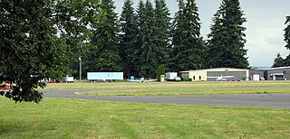
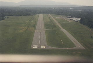
Scappoose Airport is a public use airport located one nautical mile (1.85 km) northeast of the central business district of Scappoose, in Columbia County, Oregon, United States. It is owned and operated by the Port of Columbia County, an Oregon port district and municipal corporation, on behalf of district residents. According to the FAA's National Plan of Integrated Airport Systems for 2009–2013, it is categorized as a general aviation airport.
Monticello Municipal Airport, also known as Ellis Field, is a public-use airport located two nautical miles east of the central business district of Monticello, in Drew County, Arkansas, United States. It is owned by the City of Monticello.

Sylacauga Municipal Airport, also known as Merkel Field, is a city-owned public-use airport located three nautical miles west of the central business district of Sylacauga, a city in Talladega County, Alabama, United States. It is included in the FAA's National Plan of Integrated Airport Systems for 2011–2015, which categorized it as a general aviation facility.
Shawano Municipal Airport is a city and county-owned public-use airport located one nautical mile (2 km) northeast of the central business district of Shawano, a city in Shawano County, Wisconsin, United States. It is included in the Federal Aviation Administration (FAA) National Plan of Integrated Airport Systems for 2021–2025, in which it is categorized as a local general aviation facility. The airport is located on Shawano Lake and has a landing area for seaplanes.

Princeton Municipal Airport is a city-owned public-use airport located one nautical mile southwest of the central business district of Princeton, a city in Mille Lacs County, Minnesota, United States. This airport is included in the FAA's National Plan of Integrated Airport Systems 2015–2019, which categorizes it as a general aviation airport.

Bentonville Municipal Airport is a city-owned, public-use airport located two nautical miles (3.7 km) south of the central business district of Bentonville, a city in Benton County, Arkansas, United States. It is also known as Louise M. Thaden Field or Louise Thaden Field, a name it was given in 1951 to honor Louise McPhetridge Thaden (1905–1979), an aviation pioneer from Bentonville.
Centerville Municipal Airport is a city-owned public-use airport located three nautical miles (6 km) southwest of the central business district of Centerville, a city in Appanoose County, Iowa, United States. According to the FAA's National Plan of Integrated Airport Systems for 2009–2013, it is categorized as a general aviation airport.
Red Oak Municipal Airport is a city-owned public-use airport located two nautical miles (3.7 km) west of the central business district of Red Oak, a city in Montgomery County, Iowa, United States. According to the FAA's National Plan of Integrated Airport Systems for 2009–2013, it is categorized as a general aviation facility.
Russellville Regional Airport is a city-owned public-use airport located two nautical miles (3.7 km) southeast of the central business district of Russellville, a city in Pope County, Arkansas, United States. According to the FAA's National Plan of Integrated Airport Systems for 2009–2013, it is categorized as a general aviation facility. It was formerly known as Russellville Municipal Airport.
Madison Municipal Airport is a city-owned public use airport located one nautical mile northeast of the central business district of Madison, a city in Lake County, South Dakota, United States. This airport is included in the FAA's National Plan of Integrated Airport Systems for 2009–2013, which categorized it as a general aviation facility.
Orange City Municipal Airport was a city-owned public-use airport located one nautical mile (1.85 km) south of the central business district of Orange City, a city in Sioux County, Iowa, United States. This airport was included in the FAA's National Plan of Integrated Airport Systems for 2009–2013, which categorized it as a general aviation facility.
Baker Municipal Airport is a public-use airport located one nautical mile southeast of the central business district of Baker, a city in Fallon County, Montana, United States. The airport is owned by Baker City and Fallon County. It is included in the FAA's National Plan of Integrated Airport Systems for 2011–2015, which categorized it as a general aviation facility.
Morrilton Municipal Airport is a public use airport located two nautical miles southeast of the central business district of Morrilton, in Conway County, Arkansas, United States. It is owned by the City of Morrilton.
Rugby Municipal Airport is a public use airport located two nautical miles (4 km) northwest of the central business district of Rugby, a city in Pierce County, North Dakota, United States. It is owned by the Rugby Airport Authority. This airport is included in the National Plan of Integrated Airport Systems for 2011–2015, which categorized it as a general aviation facility.
Canby Municipal Airport, also known as Myers Field, is a public use airport in Yellow Medicine County, Minnesota, United States. It is owned by the City of Canby and located one nautical mile (2 km) north of its central business district. This airport is included in the National Plan of Integrated Airport Systems for 2011–2015, which categorized it as a general aviation facility.
