Ambolafotsy Formation | |
---|---|
Stratigraphic range: Turonian ~ | |
Type | Geological formation |
Unit of | Diego Basin |
Sub-units | Lower, Middle and Upper units |
Lithology | |
Primary | Claystone, shale, sandstone |
Location | |
Coordinates | 13°48′S49°30′E / 13.8°S 49.5°E |
Approximate paleocoordinates | 33°24′S40°24′E / 33.4°S 40.4°E |
Region | Antsiranana Province |
Country | Madagascar |
The Ambolafotsy Formation is a Turonian aged geological formation in the Diego Basin of Antsiranana Province in Madagascar. It is a mostly terrestrial unit deposited during a marine regression close to the shoreline. The dinosaur Dahalokely has been discovered in the formation. [1]
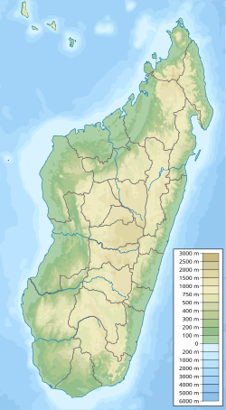
The section containing the Dahalokely site is informally termed the "Ambolafotsy Formation" and is divided into lower, middle (containing the type locality), and upper units. The lower unit has produced several biostratigraphically informative foraminifera, including Whiteinella aprica , W. baltica, Helvetoglobotruncana praehelvetica , and H. helvetica, and the nannofossil Quadrum gartneri , placing the sample within the Q. gartneri and H. helvetica zones. The upper unit contains the ammonite Subprionocyclus neptuni . [1] [2]
The sediments of most of the middle unit of the Ambolafotsy Formation are interpreted as terrestrial, deposited during a marine regression. Carbonized plant fragments are quite common in the middle unit, along with claystones, shales, and cross-bedded sandstones. Marine microfossils and macrofossils are generally absent, although a deposit of ostreids several meters above the type locality for Dahalokely suggests that the area was deposited close to the shoreline. [1] [2]
The Los Angeles Basin is a sedimentary basin located in Southern California, in a region known as the Peninsular Ranges. The basin is also connected to an anomalous group of east–west trending chains of mountains collectively known as the Transverse Ranges. The present basin is a coastal lowland area, whose floor is marked by elongate low ridges and groups of hills that is located on the edge of the Pacific plate. The Los Angeles Basin, along with the Santa Barbara Channel, the Ventura Basin, the San Fernando Valley, and the San Gabriel Basin, lies within the greater Southern California region. The majority of the jurisdictional land area of the city of Los Angeles physically lies within this basin.
The Gault Formation is a geological formation of stiff blue clay deposited in a calm, fairly deep-water marine environment during the Lower Cretaceous Period. It is well exposed in the coastal cliffs at Copt Point in Folkestone, Kent, England, where it overlays the Lower Greensand formation, and underlies the Upper Greensand Formation. These represent different facies, with the sandier parts probably being deposited close to the shore and the clay in quieter water further from the source of sediment; both are believed to be shallow-water deposits.
The Dallas–Fort Worth Metroplex sits above Cretaceous-age strata ranging from ≈145-66 Ma. These Cretaceous-aged sediments lie above the eroded Ouachita Mountains and the Fort Worth Basin, which was formed by the Ouachita Orogeny. Going from west to east in the DFW Metroplex and down towards the Gulf of Mexico, the strata get progressively younger. The Cretaceous sediments dip very gently to the east.
The Glen Rose Formation is a shallow marine to shoreline geological formation from the lower Cretaceous period exposed over a large area from South Central to North Central Texas. The formation is most widely known for the dinosaur footprints and trackways found in the Dinosaur Valley State Park near the town of Glen Rose, Texas, southwest of Fort Worth and at other localities in Central Texas.
The San Juan Basin is a geologic structural basin located near the Four Corners region of the Southwestern United States. The basin covers 7,500 square miles and resides in northwestern New Mexico, southwestern Colorado, and parts of Utah and Arizona. Specifically, the basin occupies space in the San Juan, Rio Arriba, Sandoval, and McKinley counties in New Mexico, and La Plata and Archuleta counties in Colorado. The basin extends roughly 100 miles (160 km) N-S and 90 miles (140 km) E-W.
The Tendaguru Formation, or Tendaguru Beds are a highly fossiliferous formation and Lagerstätte located in the Lindi Region of southeastern Tanzania. The formation represents the oldest sedimentary unit of the Mandawa Basin, overlying Neoproterozoic basement, separating by a long hiatus and unconformity. The formation reaches a total sedimentary thickness of more than 110 metres (360 ft). The formation ranges in age from the late Middle Jurassic to the Early Cretaceous, Oxfordian to Hauterivian stages, with the base of the formation possibly extending into the Callovian.
The Dakota is a sedimentary geologic unit name of formation and group rank in Midwestern North America. The Dakota units are generally composed of sandstones, mudstones, clays, and shales deposited in the Mid-Cretaceous opening of the Western Interior Seaway. The usage of the name Dakota for this particular Albian-Cenomanian strata is exceptionally widespread; from British Columbia and Alberta to Montana and Wisconsin to Colorado and Kansas to Utah and Arizona. It is famous for producing massive colorful rock formations in the Rocky Mountains and the Great Plains of the United States, and for preserving both dinosaur footprints and early deciduous tree leaves.
The Maevarano Formation is a Late Cretaceous sedimentary rock formation found in the Mahajanga Province of northwestern Madagascar. It is most likely Maastrichtian in age, and records a seasonal, semiarid environment with rivers that had greatly varying discharges. Notable animal fossils recovered include the theropod dinosaur Majungasaurus, the early bird Vorona, the paravian Rahonavis, the titanosaurian sauropod Rapetosaurus, and the giant frog Beelzebufo.
The Tres Hermanos Formation is a geologic formation in central and west-central New Mexico. It contains fossils characteristic of the Turonian Age of the late Cretaceous.
The Tropic Shale is a Mesozoic geologic formation. Dinosaur remains are among the fossils that have been recovered from the formation, including Nothronychus graffami. The Tropic Shale is a stratigraphic unit of the Kaiparowits Plateau of south central Utah. The Tropic Shale was first named in 1931 after the town of Tropic where the Type section is located. The Tropic Shale outcrops in Kane and Garfield counties, with large sections of exposure found in the Grand Staircase–Escalante National Monument.
The Straight Cliffs Formation is a stratigraphic unit in the Kaiparowits Plateau of south central Utah. It is Late Cretaceous in age and contains fluvial, paralic, and marginal marine (shoreline) siliciclastic strata. It is well exposed around the margin of the Kaiparowits Plateau in the Grand Staircase – Escalante National Monument in south central Utah. The formation is named after the Straight Cliffs, a long band of cliffs creating the topographic feature Fiftymile Mountain.
The Cañadón Asfalto Formation is a geological formation from the Lower Jurassic, with doubtful layers of Late Jurassic age previously referred to it. The Cañadón Asfalto Formation is located in the Cañadón Asfalto Basin, a rift basin in the Chubut Province of northwestern Patagonia, southern Argentina. The basin started forming in the earliest Jurassic.
The Sespe Formation is a widespread fossiliferous sedimentary geologic unit in southern and south central California in the United States. It is of nonmarine origin, consisting predominantly of sandstones and conglomerates laid down in a riverine, shoreline, and floodplain environment between the upper Eocene Epoch through the lower Miocene. It is often distinctive in appearance, with its sandstones weathering to reddish-brown, maroon, pinkish-gray, tan, and green. Since many of its sandstones are more resistant to erosion than many other regional sedimentary units it often forms dramatic outcrops and ridgelines in many local mountain ranges.
The Angoumian is a geological group restricted to the northern Aquitaine Basin in France. The group consists of two fossiliferous limestone formations deposited during the Turonian.
Dahalokely is an extinct genus of carnivorous abelisauroid theropod dinosaur from the Late Cretaceous (Turonian) of Madagascar.
The Atarque Sandstone is a geologic formation in New Mexico. It preserves fossils dating back to the late Cretaceous period.
One of the major depositional strata in the Himalaya is the Lesser Himalayan Strata from the Paleozoic to Mesozoic eras. It had a quite different marine succession during the Paleozoic, as most parts of it are sparsely fossiliferous or even devoid of any well-defined fossils. Moreover, it consists of many varied lithofacies, making correlation work more difficult. This article describes the major formations of the Paleozoic – Mesozoic Lesser Himalayan Strata, including the Tal Formation, Gondwana Strata, Singtali Formation and Subathu Formation.
The Drzewica Formation is a geologic formation in Szydłowiec, Poland. It is Pliensbachian in age. Vertebrate fossils have been uncovered from this formation, including dinosaur tracks. The Drzewica Formation is part of the Depositional sequence IV-VII of the late lower Jurassic Polish Basin, with the IV showing the presence of local Alluvial deposits, with possible meandriform deposition origin, dominated in Jagodne and Szydłowiec, while delta system occurred through the zone of the modern Budki. The sequence V shows a reduction of the erosion in the Zychorzyn borehole of the Drzewica Formation, showing changes on the extension of the marine facies, where upper deposits change from Alluvial to Deltaic-Seashore depositional settings. VI-VII facies were recovered on the Brody-Lubienia borehole, with a lower part exposed on the village of Śmiłów that shows a small fall of the Sea level. The stathigraphic setting of the dinosaur tracks reported from the formation suggest a Seashore or Deltaic barrier. Body fossils reported include bivalves, palynology, fossil trunks, roots. Trunks of coniferous wood, especially Cheirolepidiaceae and Araucariaceae trees show the occurrence of vast coniferous forests around the tracksite. The association of forests and dinosaur megafauna on the Pliensbachian suggests also a colder and specially dry ecosystem. Drzewica deposits where in part to be a gigantic shore barrel, setting at the time where the Polish basin sea was at its lowest point. Other related units are Fjerritslev or Gassum Formation, Hasle & Sorthat Formation (Bornholm), upper Neringa Formation (Lithuania) and abandoned informal units in other regions of Poland: upper Sawêcin beds, Wieluñ series or Bronów series.
Overoraptor is an extinct genus of paravian theropod of uncertain affinities from the Late Cretaceous Huincul Formation of Argentinian Patagonia. The genus contains a single species, O. chimentoi, known from several bones of the hands, feet, and hips alongside some vertebrae.
The Sorthat Formation is a geologic formation on the island of Bornholm, Denmark and in the Rønne Graben in the Baltic Sea. It is of Latest Pliensbachian to Late Toarcian age. Plant fossils have been recovered from the formation, along with several traces of invertebrate animals. The Sorthat Formation is overlain by fluvial to lacustrine gravels, along with sands, clay and in some places coal beds that are part of the Aalenian-Bathonian Bagå Formation. Until 2003, the Sorthat Formation was included as the lowermost part of the Bagå Formation, recovering the latest Pliensbachian to lower Aalenian boundary. The Sorthat strata reflect a mostly marginally deltaic to marine unit. Large streams fluctuated to the east, where a large river system was established at the start of the Toarcian. In the northwest, local volcanism that started in the lower Pliensbachian extended along the North Sea, mostly from southern Sweden. At this time, the Central Skåne Volcanic Province and the Egersund Basin expelled most of their material, with influences on the local tectonics. The Egersund Basin has abundant fresh porphyritic nephelinite lavas and dykes of lower Jurassic age, with a composition nearly identical to those found in the clay pits. That indicates the transport of strata from the continental margin by large fluvial channels of the Sorthat and the connected Röddinge Formation that ended in the sea deposits of the Ciechocinek Formation green series.