Ambridge Mann

Last updated
Ambridge Mann
Neighborhood
US-IN-Gary-Ambridge-Mann.png
Location within the city of Gary
Coordinates: 41°36′06″N87°21′33″W / 41.601548°N 87.359294°W / 41.601548; -87.359294 Coordinates: 41°36′06″N87°21′33″W / 41.601548°N 87.359294°W / 41.601548; -87.359294
Country Flag of the United States.svg  United States
State Flag of Indiana.svg  Indiana
County Lake County
City Gary
Founded1910
Population
 (2000) [1]
  Total6,236
Time zone UTC-6 (CST)
  Summer (DST) UTC-5 (CDT)
ZIP code
46404
Area code(s) 219

Ambridge Mann, sometimes called Ambridge-Horace Mann or Horace Mann-Ambridge, is a neighborhood in northwestern Gary, Indiana. It is bounded by the Grand Calumet River on the north, by Grant Street on the east, by Chase Street on the west, and by the Norfolk Southern railroad on the south. [2] Adjacent areas include an industrial district to the north, Downtown West to the east, Tolleston to the south, and Brunswick to the west. As of 2000, Ambridge Mann had a population of 6,236, which was 96.3% African-American. [1] Located just south of Interstate 90, the neighborhood can be seen while passing Buchanan Street.

Gary, Indiana City in Indiana, United States

Gary is a city in Lake County, Indiana, United States, 25 miles (40 km) from downtown Chicago, Illinois. Gary is adjacent to the Indiana Dunes National Park and borders southern Lake Michigan. Gary was named after lawyer Elbert Henry Gary, who was the founding chairman of the United States Steel Corporation. The city is known for its large steel mills, and as the birthplace of the Jackson 5 music group.

Grand Calumet River river in the United States

The Grand Calumet River is a 13.0-mile-long (20.9 km) river that flows primarily into Lake Michigan. Originating in Miller Beach in Gary, it flows through the cities of Gary, East Chicago and Hammond, as well as Calumet City and Burnham on the Illinois side. The majority of the river's flow drains into Lake Michigan via the Indiana Harbor and Ship Canal, sending about 1,500 cubic feet (42 m3) per second of water into the lake. A smaller part of the flow, at the river's western end, enters the Calumet River and ultimately drains into the Illinois and ultimately the Mississippi River.

Downtown West (Gary) Neighborhood in Lake County, Indiana, United States

Downtown West, is a neighborhood in north-central Gary, Indiana. Emerson and Downtown West combine to form what is known as Downtown Gary. It was part of the original plat built by the United States Steel Corporation. It is located East of Grant Street, south of the Grand Calumet River, north of 9th Avenue and west of Broadway. As of 2000, Downtown West had a population of 4,684. Downtown West borders Emerson to the east, Ambridge Mann to the west, and Midtown to the south.

The neighborhood is home to Gary's only hospital, Methodist Northlake. Schools in Ambridge Mann include Vohr Elementary and the Martin Luther King, Jr. Academy, an alternative high school. A 7-acre city park, Ambridge Park, provides public access to the Grand Calumet waterfront. In May 2011, the Gary Board of Public Works and Safety announced it was moving forward with plans to construct a bicycle trail that would run along the Grand Calumet from Gary's western border to Ambridge Park. [3] This is part of a larger Gary Green Link project, which will develop bicycle trails throughout the city.

Ambridge Mann was formerly considered to comprise two distinct neighborhoods, Ambridge and Horace Mann, lying north and south of 5th Avenue respectively. Ambridge took its name from the American Bridge Works, a subsidiary of U.S. Steel located on the north bank of the Grand Calumet River; Horace Mann was named after a school in the neighborhood. The area was whites-only until the early 1970s, when the heavily Jewish community was replaced by middle-class African-Americans. [4] Many former inhabitants of Ambridge Mann migrated to Miller Beach during this period. The neighborhood had a population of 8,920 in 1970. [5]

Miller Beach Neighborhood in Lake County, Indiana, United States

Miller Beach is a neighborhood of Gary, Indiana on the southernmost shore of Lake Michigan. First settled in 1851, Miller Beach was originally an independent town. However, the "Town of Miller" was eventually annexed by the then flourishing city of Gary in 1918. Located in the northeastern corner of Lake County, Indiana, the former town is now known as "The Miller Beach Community." Miller Beach borders Lake Michigan to the north, Porter County to the east, and is largely surrounded by protected lands, including Indiana Dunes National Park. Miller Beach is also the closest beach/resort community to Chicago, and has been a popular vacation spot since the early 20th century. As of the 2000 US census, it had a population of 9,900.

Ambridge Mann is traversed by the South Shore Line, and bisected by U.S. highways 12 and 20, which run along 4th and 5th Avenues. The Indiana Toll Road runs just north of the neighborhood, on the north bank of the Grand Calumet River, with an interchange at Grant Street in the neighborhood's northeastern corner. Buses of the Gary Public Transportation Corporation serve the neighborhood. The South Shore Line formerly stopped at Ambridge station, but service there ended in 1994. [6]

The Indiana Toll Road, officially the Indiana East–West Toll Road, is a tolled freeway that runs for 156.28 miles (251.51 km) east–west across northern Indiana from the Illinois state line to the Ohio state line. It has been advertised as the "Main Street of the Midwest". The entire toll road is designated as part of Interstate 90, and the segment from Lake Station east to the Ohio state line is a concurrency with Interstate 80. The toll road is owned by the Indiana Finance Authority and operated by the Indiana Toll Road Concession Company, which is owned by IFM Investors.

The Gary Public Transportation Corporation (GPTC) is a commuter bus system in Gary, Indiana that offers service to numerous stops throughout the city and neighboring suburbs. GPTC is a public corporation owned but not directly controlled by the city.

Ambridge was a South Shore Line flag stop located at Bridge Street in the Ambridge Mann neighborhood of Gary, Indiana. The station opened in 1920, and closed on July 5, 1994, as part of an NICTD service revision which also saw the closure of Kemil Road, Willard Avenue, LaLumiere, Rolling Prairie, and New Carlisle.

The housing stock is dominated by single-family homes, with a cluster of historic apartments along 5th Avenue; as of 2000, it had a 92% occupancy rate and 49% owner-occupancy rate. [7] The neighborhood is chiefly residential, with a small pocket of commercial activity at the intersection of 5th and Bridge. [1] The housing in Ambridge Mann was chiefly built in the first half of the twentieth century to house managers at the Gary Works. [1] The neighborhood is home to a great number of prairie style and art deco homes. The Gary Masonic Temple is located in the neighborhood along with the Ambassador Apartment building. As of 2007, the neighborhood's home values were among Gary's highest, with a median of $70,145, second only to the lakefront neighborhood of Miller Beach. [8]

Gary Works

The Gary Works is a major steel mill in Gary, Indiana, on the shore of Lake Michigan. For many years, the Gary Works was the world's largest steel mill, and it remains the largest integrated mill in North America. It is operated by the United States Steel Corporation.

Famous people from Ambridge Mann include Nobel laureate Joseph Stiglitz, who grew up in a brick bungalow near the river on Arthur Street. [9]

Joseph Stiglitz American economist, professor, and recipient of the Nobel Memorial Prize in Economics

Joseph Eugene Stiglitz is an American economist, public policy analyst, and a professor at Columbia University. He is a recipient of the Nobel Memorial Prize in Economic Sciences (2001) and the John Bates Clark Medal (1979). He is a former senior vice president and chief economist of the World Bank and is a former member and chairman of the Council of Economic Advisers. He is known for his support of Georgist public finance theory and for his critical view of the management of globalization, of laissez-faire economists, and of international institutions such as the International Monetary Fund and the World Bank.

Related Research Articles

Calumet River river in the United States of America

The Calumet River is a system of heavily industrialized rivers and canals in the region between the neighborhood of South Chicago in Chicago, Illinois, and the city of Gary, Indiana. Historically, the Little Calumet River and the Grand Calumet River were one, the former flowing west from Indiana into Illinois, then turning back east to its mouth at Lake Michigan at Marquette Park in Gary.

East Side, Chicago Community area in Chicago

East Side is one of the 77 official community areas of Chicago, Illinois. It is on the far south side of the city, between the Calumet River and the Illinois-Indiana state line, 13 miles (21 km) south of downtown Chicago. The neighborhood has a park on Lake Michigan, Calumet Park, and a forest, Eggers Grove Forest Preserve. The forest preserve has hiking/walking trails, picnic grounds and birdwatching. It is served by U.S. Highway 12, U.S. Highway 20, and U.S. Highway 41.

Hegewisch, Chicago Community area in Chicago

Hegewisch is one of the 77 community areas of Chicago, Illinois, located on the city's far south side. It is bordered by the neighborhoods of Riverdale and South Deering to the west, the East Side to the north, the village of Burnham to the south and the city of Hammond, Indiana to the east. The community area is named for Adolph Hegewisch, the president of U.S. Rolling Stock Company who hoped to establish "an ideal workingman's community" when he laid out the town along a rail line in 1883, six years before Chicago annexed the town.

Monon Trail walking/ biking trail in Indiana

The Monon Trail is a rail trail located entirely within the state of Indiana. The Monon Railroad was a popular railroad line connecting the cities of Chicago and Indianapolis, with stops at major settlements along its route. After the decline of railroad travel and the sale of the company in 1987, the portion of the line between Indianapolis and Delphi, Indiana, was abandoned.

Tolleston Neighborhood in Lake County, Indiana, United States

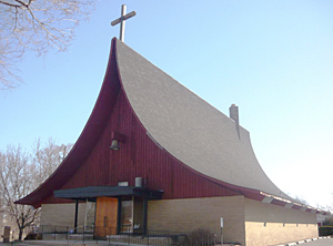
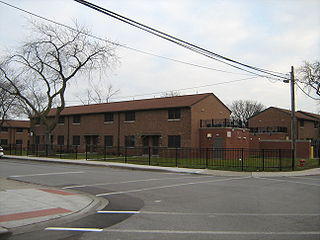
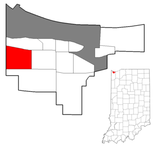
Tolleston is a neighborhood and former town in west-central Gary, Indiana. It is situated south of Ambridge, west of Midtown, east of Westside and north of Black Oak. Tolleston is the site of two large city parks, a historic cemetery, and the oldest church north of the Little Calumet River. The neighborhood's borders are defined by the Norfolk Southern tracks on the north, Grant Street on the east, 25th Avenue on the south, and Clark Road on the west. As of 2000, Tolleston had a population of 14,289, and was 97.5% African-American.

Aetna (Gary) Neighborhood in Lake County, Indiana, United States

Aetna is a neighborhood in northeastern Gary, Indiana, south of Miller Beach and east of Interstate 65. As of 2000, the neighborhood had a population of 4,942, which was 83% black and 11% white.

Glen Park (Gary) Neighborhood in Lake County, Indiana, United States

Glen Park, also sometimes called University Park, is the most populous neighborhood in Gary, Indiana. It is situated on the city's far south side, south of the Little Calumet River and Borman Expressway. The neighborhood is often divided into Glen Park East and Glen Park West, on the respective sides of Broadway. Within Gary, Glen Park borders on Black Oak to the west and Midtown and Pulaski to the north; beyond Gary, it adjoins Hobart, Merrillville, and unincorporated Calumet Township. As of 2000, the neighborhood had a population of 25,454, approximately a quarter of Gary's total population. In terms of race, as of 2000 Glen Park was 86% African-American, 9% white, and 5.5% Hispanic.

Black Oak (Gary) Neighborhood in Lake County, Indiana, United States

Black Oak is a neighborhood located on the far southwest side of Gary, Indiana. As of 2000, Black Oak had a population of 4,216, which was 84.7% white. It is Gary's only majority-white neighborhood, and the most recent neighborhood added to the city. Black Oak was annexed in 1976, under the administration of mayor Richard Hatcher. Prior to that, Black Oak had been an unincorporated area informally associated with nearby Hammond, and the area has Hammond telephone numbers.

Brunswick (Gary) Neighborhood in Lake County, Indiana, United States

Brunswick is a neighborhood in northwestern Gary, Indiana, just south of Gary Chicago Airport. It borders Hammond and East Chicago to the west, and the Gary neighborhoods of Ambridge Mann to the east and Westside to the south. The borders are defined by the Indiana Toll Road on the north, Chase Street on the east, the Norfolk Southern railway on the south and Cline Avenue on the west. As of 2000, Brunswick had a population of 4,442 people, which was 84.6% African-American and 7.7% white. Like many Gary neighborhoods, Brunswick was a segregated white community until the early 1970s, when massive white flight occurred.

Westside (Gary) Neighborhood in Lake County, Indiana, United States

Westside is a neighborhood in west-central Gary, Indiana, USA, bounded by the Cline Avenue expressway on the west, the Norfolk Southern railroad on the north, Clark Road on the east and 25th Avenue on the south. It lies directly east of the Hessville neighborhood of Hammond. Within Gary, it adjoins the neighborhoods of Brunswick, Tolleston and Black Oak. In 2000, Westside had a population of 6,153, which was 63.3% African-American and 31.9% white, with 10.1% Hispanic ethnicity.

Pulaski (Gary) Neighborhood in Lake County, Indiana, United States

Pulaski is a neighborhood in eastern Gary, Indiana. It is roughly triangular in shape, bounded on the south by the Borman Expressway, on the west by Maryland Street, and on the northeast by the Norfolk Southern railway. It is separated by an industrial corridor from Aetna to its east and Emerson to its north; it directly adjoins the neighborhoods of Midtown and Glen Park. As of 2000, Pulaski's population was 6,777, which was 96.7% African-American, 1.4% white, and 1.3% of Hispanic ethnicity.

Emerson (Gary) Neighborhood in Lake County, Indiana, United States

Emerson, also called Downtown East, is a neighborhood in north-central Gary, Indiana. Emerson and Downtown West combine to form what is known as Downtown Gary. It was part of the original plat built by the United States Steel Corporation. Emerson is located east of Broadway, south of the Grand Calumet River, north of Ninth Avenue and west of Interstate 65. As of 2000, it had a population of 3,358. Emerson borders directly on Downtown West to the west but is separated from the Aetna and Pulaski neighborhoods to the east and south by an industrial corridor.

Downtown Gary Neighborhood in Lake County, Indiana, United States

Downtown Gary is split by Broadway into two separate neighborhoods in north-central Gary, Indiana. Emerson and Downtown West combine to form what is known as Downtown Gary. It was part of the original plat built by the United States Steel Corporation. It is located east of Grant Street, south of the Grand Calumet River, north of 9th Avenue and west of Interstate 65. Downtown West borders Ambridge Mann to the west and Midtown to the south, but it is separated from the Aetna and Pulaski neighborhoods to the east and south by an industrial corridor.

South Hammond Neighborhood in Lake County, Indiana, United States

South Hammond is a neighborhood in southwestern Hammond, Indiana, approximately between the Illinois state line and Columbia Avenue, south of 165th Street. It is bounded to the east by Woodmar, to the south by the towns of Munster and Highland, to the west by Calumet City, Illinois, and to the north by Central Hammond. The Little Calumet River snakes along the neighborhood's southern boundary. The neighborhood's boundaries correspond to Hammond's Planning District IV.

Central Hammond Neighborhood in Lake County, Indiana, United States

Central Hammond is a neighborhood in western Hammond, Indiana, approximately between the Illinois state line and White Oak Avenue, north of 165th Street. It is bounded to the south by South Hammond and Woodmar, to the west by Calumet City, Illinois, to the north by North Hammond, and to the east by the East Chicago neighborhoods of Roxana and Southside. The sinuous Grand Calumet River marks the neighborhood's northern boundary. The neighborhood's boundaries correspond to Hammond's Planning District III.

North Hammond is a neighborhood in western Hammond, Indiana, north of the Grand Calumet River and south of Wolf Lake. It is bounded to the south by Central Hammond, to the west by the Chicago neighborhood of Hegewisch, to the north by Robertsdale, and to the east by East Chicago. The neighborhood's boundaries correspond to Hammond's Planning District II. The neighborhood is traversed by the Indiana Toll Road, which has an exit into the neighborhood at Calumet Avenue, and by the South Shore Line railroad. Passenger trains for the Northern Indiana Commuter Transportation District stop at Hammond Station in the neighborhood.

Calumet is the portion of East Chicago, Indiana located east of the Indiana Harbor and Ship Canal and south of Chicago Avenue. The neighborhood is bisected by the Indiana Harbor Belt Railroad. The area west of the tracks is referred to as Calumet proper, or as "West Calumet". The area east of the tracks is known as "East Calumet."

References

  1. 1 2 3 4 City of Gary 2008, p. 140.
  2. City of Gary 2008, p. 139.
  3. Michael Gonzalez (2011-05-12). "Gary Green Link trail moving forward". Post-Tribune. Archived from the original on 2012-03-24. Retrieved 2011-06-08.
  4. Catlin 1993, p. 94.
  5. Catlin 1993, p. 90.
  6. "NICTD proposed flag stop consolidation plan" (PDF). The Indiana Passenger Letter. 13 (3). May 1994.
  7. City of Gary 2008, p. 112.
  8. City of Gary 2008, p. 114.
  9. Greising, David (2006-10-01). "Global forces find Gary". Chicago Tribune.