Emerson (Gary)

Last updated
Emerson
Neighborhood
Gary City Hall, 2009.jpg
City Hall
US-IN-Gary-Emerson.png
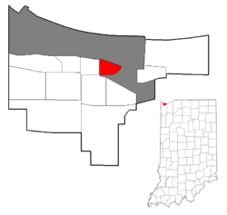
Location within the city of Gary
Coordinates: 41°36′10″N87°19′56″W / 41.602869°N 87.332217°W / 41.602869; -87.332217 Coordinates: 41°36′10″N87°19′56″W / 41.602869°N 87.332217°W / 41.602869; -87.332217
Country Flag of the United States.svg  United States
State Flag of Indiana.svg  Indiana
County Lake County
City Gary
Founded1906
Population
 (2000) [1]
  Total3,358
Time zone UTC-6 (CST)
  Summer (DST) UTC-5 (CDT)
ZIP code
46402
Area code(s) 219

Emerson, also called Downtown East, is a neighborhood in north-central Gary, Indiana. Emerson and Downtown West combine to form what is known as Downtown Gary. It was part of the original plat built by the United States Steel Corporation. Emerson is located east of Broadway, south of the Grand Calumet River, north of Ninth Avenue and west of Interstate 65. As of 2000, it had a population of 3,358. [1] Emerson borders directly on Downtown West to the west but is separated from the Aetna and Pulaski neighborhoods to the east and south by an industrial corridor. [2]

Gary, Indiana City in Indiana, United States

Gary is a city in Lake County, Indiana, United States, 25 miles (40 km) from downtown Chicago, Illinois. Gary is adjacent to the Indiana Dunes National Park and borders southern Lake Michigan. Gary was named after lawyer Elbert Henry Gary, who was the founding chairman of the United States Steel Corporation. The city is known for its large steel mills, and as the birthplace of the Jackson 5 music group.

Downtown Gary Neighborhood in Lake County, Indiana, United States

Downtown Gary is split by Broadway into two separate neighborhoods in north-central Gary, Indiana. Emerson and Downtown West combine to form what is known as Downtown Gary. It was part of the original plat built by the United States Steel Corporation. It is located east of Grant Street, south of the Grand Calumet River, north of 9th Avenue and west of Interstate 65. Downtown West borders Ambridge Mann to the west and Midtown to the south, but it is separated from the Aetna and Pulaski neighborhoods to the east and south by an industrial corridor.

Plat map showing a piece of land, drawn to scale, with details such as nearby properties, boundaries, land size, flood zones, the surrounding neighborhood, easements, and monuments

In the United States, a plat is a map, drawn to scale, showing the divisions of a piece of land. United States General Land Office surveyors drafted township plats of Public Lands Surveys to show the distance and bearing between section corners, sometimes including topographic or vegetation information. City, town or village plats show subdivisions into blocks with streets and alleys. Further refinement often splits blocks into individual lots, usually for the purpose of selling the described lots; this has become known as subdivision.

Emerson has a large number of vacant lots and abandoned buildings and the lowest number of housing units in the city. [3] About 40% of the houses are owner-occupied. [1] There are 44 new housing units between Fifth and Sixth Avenues. [1] Emerson is served by the Gary Main Post Office. In the past it was served by the now decaying E.A. Spaulding Elementary School and Emerson School for Visual and Performing Arts; both schools now stand vacant. [4] Emerson has two city parks, Buffington Park, Idle Hour Park, and the larger portion of Gateway Park. [5]

U.S. Steel Yard Gary Steelyard.jpg
U.S. Steel Yard

Gary City Hall is located in Emerson along with the Indiana Department of Social Services building and the Calumet Township Trustee’s office. In 2001 the U.S. Steel Yard baseball stadium was built in an effort to stimulate a rebirth of the downtown. It was built on what was once a blighted section of housing. Its construction was highly controversial. However, it has proven somewhat successful, drawing fans from surrounding communities. [5] In September 2009, the one millionth fan walked into the U.S. Steel Yard. [6] Much of the commercial property along Broadway is now vacant. But there are some newer properties along Fifth Avenue.

U.S. Steel Yard

U.S. Steel Yard is an open-air baseball stadium located in Gary, Indiana next to I-90 in the city's Emerson neighborhood. It is home to the Gary SouthShore RailCats, a professional baseball team and member of the American Association. It seats 6,139 people. It also hosts many Little League Baseball games as well as high school baseball games. The ballpark is notable for holding a memorial service for the late pop musician and Gary native Michael Jackson on July 10, 2009 that was attended by over 6,000 fans, with much of Jackson's family in attendance. The ballpark has had over 2 million fans in attendance during the RailCats team history.

The neighborhood is served by the Indiana Toll Road directly to its north, which has exits at Broadway and Fifth Avenue; by Interstate 65 to the east, which has an exit on Fifth Avenue; and by US 12 /20, also to the north. Public transportation is provided by Gary Public Transportation Corporation, with buses running along Broadway and Fifth Avenue.

The Indiana Toll Road, officially the Indiana East–West Toll Road, is a tolled freeway that runs for 156.28 miles (251.51 km) east–west across northern Indiana from the Illinois state line to the Ohio state line. It has been advertised as the "Main Street of the Midwest". The entire toll road is designated as part of Interstate 90, and the segment from Lake Station east to the Ohio state line is a concurrency with Interstate 80. The toll road is owned by the Indiana Finance Authority and operated by the Indiana Toll Road Concession Company, which is owned by IFM Investors.

Interstate 65 (I-65) is a major Interstate Highway in the central United States. As with most interstates that end in a five, it is a major cross-country, north-south route, connecting the Gulf of Mexico to the Great Lakes. Its southern terminus is located at an interchange with I-10 in Mobile, Alabama, and its northern terminus is at an interchange with I-90, U.S. Route 12 (US 12), and U.S. Route 20 in Gary, Indiana, just southeast of Chicago.

U.S. Route 12 (US 12) is a part of the United States Numbered Highway System that runs from Aberdeen, Washington, to Detroit, Michigan. In the U.S. state of Indiana, it is part of the state road system. US 12 enters the state concurrent with US 20 and US 41 in Whiting. The 45.16 miles (72.68 km) of US 12 that lie within Indiana serve as a major conduit. Some of the highway is listed on the National Highway System. Various sections are rural two-lane highway, urbanized four-lane undivided highway and one-way streets. The easternmost community along the highway is Michiana Shores at the Michigan state line.

Related Research Articles

Downtown Pittsburgh Neighborhood of Pittsburgh in Allegheny County, Pennsylvania, United States

Downtown Pittsburgh, colloquially referred to as the Golden Triangle, and officially the Central Business District, is the urban downtown center of Pittsburgh. It is located at the confluence of the Allegheny River and the Monongahela River whose joining forms the Ohio River. The "triangle" is bounded by the two rivers. The area features offices for major corporations such as PNC Bank, U.S. Steel, PPG, Bank of New York Mellon, Heinz, Federated Investors and Alcoa. It is where the fortunes of such industrial barons as Andrew Carnegie, Henry Clay Frick, Henry J. Heinz, Andrew Mellon and George Westinghouse were made. It contains the site where the French fort, Fort Duquesne, once stood.

East Side, Chicago Community area in Chicago

East Side is one of the 77 official community areas of Chicago, Illinois. It is on the far south side of the city, between the Calumet River and the Illinois-Indiana state line, 13 miles (21 km) south of downtown Chicago. The neighborhood has a park on Lake Michigan, Calumet Park, and a forest, Eggers Grove Forest Preserve. The forest preserve has hiking/walking trails, picnic grounds and birdwatching. It is served by U.S. Highway 12, U.S. Highway 20, and U.S. Highway 41.

Interstate 94 (I-94) is a part of the Interstate Highway System that runs from Billings, Montana, to Port Huron, Michigan. I-94 enters Indiana from Illinois in the west, in Munster and runs generally eastward through Hammond, Gary and Portage, before entering Michigan northeast of Michigan City. The interstate runs for approximately 45.75 miles (73.63 km) through the state. The landscape traversed by I-94 includes urban areas of Northwest Indiana, wooded areas, and farmland. The section of I-94 between the Illinois state line and Lake Station is named the Borman Expressway.

Miller Beach Neighborhood in Lake County, Indiana, United States

Miller Beach is a neighborhood of Gary, Indiana on the southernmost shore of Lake Michigan. First settled in 1851, Miller Beach was originally an independent town. However, the "Town of Miller" was eventually annexed by the then flourishing city of Gary in 1918. Located in the northeastern corner of Lake County, Indiana, the former town is now known as "The Miller Beach Community." Miller Beach borders Lake Michigan to the north, Porter County to the east, and is largely surrounded by protected lands, including Indiana Dunes National Park. Miller Beach is also the closest beach/resort community to Chicago, and has been a popular vacation spot since the early 20th century. As of the 2000 US census, it had a population of 9,900.

Twenty-four business routes of Interstate 15 exist. Former routes also exist.

Streets of Albany, New York

The streets of Albany, New York have had a long history going back almost 400 years. Many of the streets have changed names over the course of time, some have changed names many times. Some streets no longer exist, others have changed course. Some roads existed only on paper. The oldest streets were haphazardly laid out with no overall plan until Simeon De Witt's 1794 street grid plan. The plan had two grids, one west of Eagle Street and the old stockade, and another for the Pastures District south of the old stockade.

Tolleston Neighborhood in Lake County, Indiana, United States

Tolleston is a neighborhood and former town in west-central Gary, Indiana. It is situated south of Ambridge, west of Midtown, east of Westside and north of Black Oak. Tolleston is the site of two large city parks, a historic cemetery, and the oldest church north of the Little Calumet River. The neighborhood's borders are defined by the Norfolk Southern tracks on the north, Grant Street on the east, 25th Avenue on the south, and Clark Road on the west. As of 2000, Tolleston had a population of 14,289, and was 97.5% African-American.

Aetna (Gary) Neighborhood in Lake County, Indiana, United States

Aetna is a neighborhood in northeastern Gary, Indiana, south of Miller Beach and east of Interstate 65. As of 2000, the neighborhood had a population of 4,942, which was 83% black and 11% white.

Ambridge Mann Neighborhood in Lake County, Indiana, United States

Ambridge Mann, sometimes called Ambridge-Horace Mann or Horace Mann-Ambridge, is a neighborhood in northwestern Gary, Indiana. It is bounded by the Grand Calumet River on the north, by Grant Street on the east, by Chase Street on the west, and by the Norfolk Southern railroad on the south. Adjacent areas include an industrial district to the north, Downtown West to the east, Tolleston to the south, and Brunswick to the west. As of 2000, Ambridge Mann had a population of 6,236, which was 96.3% African-American. Located just south of Interstate 90, the neighborhood can be seen while passing Buchanan Street.

Glen Park (Gary) Neighborhood in Lake County, Indiana, United States

Glen Park, also sometimes called University Park, is the most populous neighborhood in Gary, Indiana. It is situated on the city's far south side, south of the Little Calumet River and Borman Expressway. The neighborhood is often divided into Glen Park East and Glen Park West, on the respective sides of Broadway. Within Gary, Glen Park borders on Black Oak to the west and Midtown and Pulaski to the north; beyond Gary, it adjoins Hobart, Merrillville, and unincorporated Calumet Township. As of 2000, the neighborhood had a population of 25,454, approximately a quarter of Gary's total population. In terms of race, as of 2000 Glen Park was 86% African-American, 9% white, and 5.5% Hispanic.

Black Oak (Gary) Neighborhood in Lake County, Indiana, United States

Black Oak is a neighborhood located on the far southwest side of Gary, Indiana. As of 2000, Black Oak had a population of 4,216, which was 84.7% white. It is Gary's only majority-white neighborhood, and the most recent neighborhood added to the city. Black Oak was annexed in 1976, under the administration of mayor Richard Hatcher. Prior to that, Black Oak had been an unincorporated area informally associated with nearby Hammond, and the area has Hammond telephone numbers.

Brunswick (Gary) Neighborhood in Lake County, Indiana, United States

Brunswick is a neighborhood in northwestern Gary, Indiana, just south of Gary Chicago Airport. It borders Hammond and East Chicago to the west, and the Gary neighborhoods of Ambridge Mann to the east and Westside to the south. The borders are defined by the Indiana Toll Road on the north, Chase Street on the east, the Norfolk Southern railway on the south and Cline Avenue on the west. As of 2000, Brunswick had a population of 4,442 people, which was 84.6% African-American and 7.7% white. Like many Gary neighborhoods, Brunswick was a segregated white community until the early 1970s, when massive white flight occurred.

Westside (Gary) Neighborhood in Lake County, Indiana, United States

Westside is a neighborhood in west-central Gary, Indiana, USA, bounded by the Cline Avenue expressway on the west, the Norfolk Southern railroad on the north, Clark Road on the east and 25th Avenue on the south. It lies directly east of the Hessville neighborhood of Hammond. Within Gary, it adjoins the neighborhoods of Brunswick, Tolleston and Black Oak. In 2000, Westside had a population of 6,153, which was 63.3% African-American and 31.9% white, with 10.1% Hispanic ethnicity.

Pulaski (Gary) Neighborhood in Lake County, Indiana, United States

Pulaski is a neighborhood in eastern Gary, Indiana. It is roughly triangular in shape, bounded on the south by the Borman Expressway, on the west by Maryland Street, and on the northeast by the Norfolk Southern railway. It is separated by an industrial corridor from Aetna to its east and Emerson to its north; it directly adjoins the neighborhoods of Midtown and Glen Park. As of 2000, Pulaski's population was 6,777, which was 96.7% African-American, 1.4% white, and 1.3% of Hispanic ethnicity.

Downtown West (Gary) Neighborhood in Lake County, Indiana, United States

Downtown West, is a neighborhood in north-central Gary, Indiana. Emerson and Downtown West combine to form what is known as Downtown Gary. It was part of the original plat built by the United States Steel Corporation. It is located East of Grant Street, south of the Grand Calumet River, north of 9th Avenue and west of Broadway. As of 2000, Downtown West had a population of 4,684. Downtown West borders Emerson to the east, Ambridge Mann to the west, and Midtown to the south.

Calumet is the portion of East Chicago, Indiana located east of the Indiana Harbor and Ship Canal and south of Chicago Avenue. The neighborhood is bisected by the Indiana Harbor Belt Railroad. The area west of the tracks is referred to as Calumet proper, or as "West Calumet". The area east of the tracks is known as "East Calumet."

Prairie Park is a neighborhood in the Indiana Harbor section of East Chicago, Indiana. It is bounded on the north by U.S. 12, and on the south by Indiana 312. To the west, it looks across Elm Street at the Washington Park neighborhood, and to the east it is bounded by the Cline Avenue expressway and industrial northern Gary beyond.

References

  1. 1 2 3 4 City of Gary 2008, p. 145.
  2. City of Gary 2008, p. 134.
  3. City of Gary 2008, p. 112.
  4. Carmen McCollum. "Some Gary school buildings to get a new life" . Retrieved 2013-03-16.
  5. 1 2 City of Gary 2008, p. 146.
  6. Steinberg, Neil (2009-09-13). "Gary shows signs of hope, revival". Chicago Sun Times. Archived from the original on 2009-09-22. Retrieved 2009-10-01.