
Gary is a city in Lake County, Indiana, United States. The population was 69,093 at the 2020 census, making it Indiana's eleventh-most populous city. The city has been historically dominated by major industrial activity and is home to U.S. Steel's Gary Works, the largest steel mill complex in North America. Gary is located along the southern shore of Lake Michigan about 25 miles (40 km) southeast of downtown Chicago. The city is the western gateway to the Indiana Dunes National Park, and is within the Chicago metropolitan area.
The Syracuse Far Westside is one of 26 neighborhoods recognized by the City of Syracuse, New York. Until this area joined the city in 1886 it was known as the Village of Geddes.

Hegewisch is one of the 77 community areas of Chicago, Illinois, located on the city's far south side. It is bordered by the neighborhoods of Riverdale and South Deering to the west, the East Side to the north, the village of Burnham to the south and the city of Hammond, Indiana to the east. The community area is named for Adolph Hegewisch, the president of U.S. Rolling Stock Company who hoped to establish "an ideal workingman's community" when he laid out the town along a rail line in 1883, six years before Chicago annexed the town.
Queen Village is a residential neighborhood of Philadelphia, Pennsylvania, United States that lies along the eastern edge of the city in South Philadelphia. It shares boundaries with Society Hill to the north, Bella Vista to the west and Pennsport to the south. Street boundaries are the south side of Lombard Street to the north side of Washington Avenue, the Delaware River to 6th Street, encompassing two principal commercial corridors, South Street and Fabric Row on 4th Street.
The Gary Public Transportation Corporation (GPTC) is a commuter bus system in Gary, Indiana that offers service to numerous stops throughout the city and neighboring suburbs. GPTC is a public corporation owned but not directly controlled by the city.

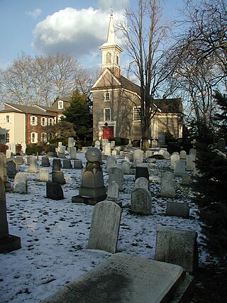
Miller Beach is a neighborhood of Gary, Indiana on the southernmost shore of Lake Michigan. First settled in 1851, Miller Beach was originally an independent town. However, the "Town of Miller" was eventually annexed by the then flourishing city of Gary in 1918. Located in the northeastern corner of Lake County, Indiana, the former town is now known as "The Miller Beach Community." Miller Beach borders Lake Michigan to the north, Porter County to the east, and is largely surrounded by protected lands, including Indiana Dunes National Park. Miller Beach is also the closest beach/resort community to Chicago, and has been a popular vacation spot since the early 20th century. As of the 2000 US census, it had a population of 9,900.

Lincoln Park is a neighborhood and public park close to downtown Denver, Colorado and the location of the Art District on Santa Fe. The neighborhood is one of Denver's oldest and is just to the south of the area where Denver was first settled in the 1850s. Many houses date from about 1900. The neighborhood is sometimes called "La Alma/Lincoln Park" or the West Side.

English Avenue and Vine City are two adjacent and closely linked neighborhoods of Atlanta, Georgia. Together the neighborhoods make up neighborhood planning unit L. The two neighborhoods are frequently cited together in reference to shared problems and to shared redevelopment schemes and revitalization plans.
Tolleston is a neighborhood and former town in west-central Gary, Indiana. It is situated south of Ambridge, west of Midtown, east of Westside and north of Black Oak. Tolleston is the site of two large city parks, a historic cemetery, and the oldest church north of the Little Calumet River. The neighborhood's borders are defined by the Norfolk Southern tracks on the north, Grant Street on the east, 25th Avenue on the south, and Clark Road on the west. As of 2000, Tolleston had a population of 14,289, and was 97.5% African-American.

Aetna is a neighborhood in northeastern Gary, Indiana, south of Miller Beach and east of Interstate 65. As of 2000, the neighborhood had a population of 4,942, which was 83% black and 11% white.

Ambridge Mann, sometimes called Ambridge-Horace Mann or Horace Mann-Ambridge, is a neighborhood in northwestern Gary, Indiana. It is bounded by the Grand Calumet River on the north, by Grant Street on the east, by Chase Street on the west, and by the Norfolk Southern railroad on the south. Adjacent areas include an industrial district to the north, Downtown West to the east, Tolleston to the south, and Brunswick to the west. As of 2000, Ambridge Mann had a population of 6,236, which was 96.3% African-American. Located just south of Interstate 90, the neighborhood can be seen while passing Buchanan Street.

Glen Park, also sometimes called University Park, is the most populous neighborhood in Gary, Indiana. It is situated on the city's far south side, south of the Little Calumet River and Borman Expressway. The neighborhood is often divided into Glen Park East and Glen Park West, on the respective sides of Broadway. Within Gary, Glen Park borders on Black Oak to the west and Midtown and Pulaski to the north; beyond Gary, it adjoins Hobart, Merrillville, and unincorporated Calumet Township. As of 2000, the neighborhood had a population of 25,454, approximately a third of Gary's total population. In terms of race, as of 2000 Glen Park was 86% African-American, 9% white, and 5.5% Hispanic.

Midtown, also called Central, is a neighborhood in central Gary, Indiana. For many decades it was the only African-American neighborhood in the city. It is located south of Downtown West and north of Glen Park along Broadway, Gary's principal thoroughfare. It adjoins the neighborhoods of Tolleston to the west and Pulaski to the east. As of 2000, Midtown had a population of 12,056.

Black Oak is a neighborhood located on the far southwest side of Gary, Indiana. As of 2000, Black Oak had a population of 4,216, which was 84.7% white. It is Gary's only majority-white neighborhood, and the most recent neighborhood added to the city. Black Oak was annexed in 1976, under the administration of mayor Richard Hatcher. Prior to that, Black Oak had been an unincorporated area informally associated with nearby Hammond, and the area has Hammond telephone numbers.

Brunswick is a neighborhood in northwestern Gary, Indiana, just south of Gary Chicago Airport. It borders Hammond and East Chicago to the west, and the Gary neighborhoods of Ambridge Mann to the east and Westside to the south. The borders are defined by the Indiana Toll Road on the north, Chase Street on the east, the Norfolk Southern railway on the south and Cline Avenue on the west. As of 2000, Brunswick had a population of 4,442 people, which was 84.6% African-American and 7.7% white. Like many Gary neighborhoods, Brunswick was a segregated white community until the early 1970s, when a massive white flight occurred.

Pulaski is a neighborhood in eastern Gary, Indiana. It is roughly triangular in shape, bounded on the south by the Borman Expressway, on the west by Maryland Street, and on the northeast by the Norfolk Southern railway. It is separated by an industrial corridor from Aetna to its east and Emerson to its north; it directly adjoins the neighborhoods of Midtown and Glen Park. As of 2000, Pulaski's population was 6,777, which was 96.7% African-American, 1.4% white, and 1.3% of Hispanic ethnicity.

Emerson, also called Downtown East, is a neighborhood in north-central Gary, Indiana. Emerson and Downtown West combine to form what is known as Downtown Gary. It was part of the original plat built by the United States Steel Corporation. Emerson is located east of Broadway, south of the Grand Calumet River, north of Ninth Avenue and west of Interstate 65. As of 2000, it had a population of 3,358. Emerson borders directly on Downtown West to the west but is separated from the Aetna and Pulaski neighborhoods to the east and south by an industrial corridor.

Downtown West, is a neighborhood in north-central Gary, Indiana. Emerson and Downtown West combine to form what is known as Downtown Gary. It was part of the original plat built by the United States Steel Corporation. It is located East of Grant Street, south of the Grand Calumet River, north of 9th Avenue and west of Broadway. As of 2000, Downtown West had a population of 4,684. Downtown West borders Emerson to the east, Ambridge Mann to the west, and Midtown to the south.

Downtown Gary is split by Broadway into two separate neighborhoods in north-central Gary, Indiana, United States. Emerson and Downtown West combine to form what is known as Downtown Gary. It was part of the original plat built by the United States Steel Corporation. It is located east of Grant Street, south of the Grand Calumet River, north of 9th Avenue, and west of Interstate 65. Downtown West borders Ambridge Mann to the west and Midtown to the south, but it is separated from the Aetna and Pulaski neighborhoods to the east and south by an industrial corridor.
Pigeon Town is a New Orleans, Louisiana neighborhood located in the 17th Ward of New Orleans and within the larger Carrollton neighborhood, and within the area that the New Orleans city planning commission calls "Leonidas." Pigeon Town is (loosely) bordered by Cambronne St. (East), Claiborne Ave. (north), Oak St. (South) and the Orleans-Jefferson parish line on the west. It is situated directly between the Hollygrove neighborhood and the Oak Street Cultural Arts District.
