Brunswick | |
---|---|
Neighborhood | |
Coordinates: 41°36′08″N87°24′12″W / 41.602158°N 87.403293°W Coordinates: 41°36′08″N87°24′12″W / 41.602158°N 87.403293°W | |
Country | United States |
State | Indiana |
County | Lake County |
City | Gary |
Population (2000) [1] | |
• Total | 4,442 |
Time zone | UTC-6 (CST) |
• Summer (DST) | UTC-5 (CDT) |
ZIP code | 46406 |
Area code | 219 |
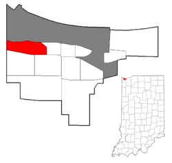
Brunswick is a neighborhood in northwestern Gary, Indiana, just south of Gary Chicago Airport. It borders Hammond and East Chicago to the west, and the Gary neighborhoods of Ambridge Mann to the east and Westside to the south. The borders are defined by the Indiana Toll Road on the north, Chase Street on the east, the Norfolk Southern railway on the south and Cline Avenue on the west. [1] As of 2000, Brunswick had a population of 4,442 people, which was 84.6% African-American and 7.7% white. [1] Like many Gary neighborhoods, Brunswick was a segregated white community until the early 1970s, when a massive white flight occurred. [2]
As of 2000, the neighborhood's housing stock had a 90% occupancy rate and a 68% owner-occupancy rate. [3] It was dominated by single-family homes, with 10% consisting of multi-family dwellings. [4] The neighborhood is the site of a major shopping plaza, with additional commercial development clustered along U.S. 20. There are two private elementary schools, West Gary Lighthouse and Aspire Charter Academy, and one public elementary school, Brunswick Elementary.
Brunswick was formerly served by its own post office. However, the Brunswick Station post office was closed in February 2011, and its operations were merged into those of the post office in Tolleston. [5] Brunswick is served by its own branch of the Gary Public Library, which was established in 1959 but only moved into a dedicated space in 2003. [6]
Transportation connections in Brunswick include rail, highway, and air. The Gary/Chicago International Airport is located directly north of the neighborhood, and the neighborhood is served by the Clark Road station on the South Shore Line. The Cline Avenue expressway runs just west of Brunswick, and also affords access to the Indiana Toll Road which runs north of the neighborhood. At surface level, the neighborhood is traversed by U.S. 20, and is served by the buses of the Gary Public Transportation Corporation.
Remnant areas of dune and swale habitat exist in Brunswick. [7] Examples include the 110-acre Ivanhoe nature preserve operated by the Nature Conservancy, and the Clark and Pine Nature Preserve operated by the Indiana Department of Natural Resources, which has the highest concentration of rare and endangered species of any Indiana nature preserve. [8] The neighborhood is home to a 49-acre city park, Brunswick Park, which also incorporates areas of remnant dune and swale. [8]
The sewage treatment plant of the Gary Sanitary District is located in Brunswick, near the Grand Calumet River. [9]
Lake County is a county located in the U.S. state of Indiana. In 2020, its population was 498,700, making it Indiana's second-most populous county. The county seat is Crown Point. The county is part of Northwest Indiana and the Chicago metropolitan area, and contains a mix of urban, suburban and rural areas. It is bordered on the north by Lake Michigan and contains a portion of the Indiana Dunes. It includes Marktown, Clayton Mark's planned worker community in East Chicago.
Hammond is a city in Lake County, Indiana, United States. It is part of the Chicago metropolitan area, and the only city in Indiana to border Chicago. First settled in the mid-19th century, it is one of the oldest cities of northern Lake County. As of the 2020 United States census, it is also the largest in population. The 2020 population was 77,879, replacing Gary as the most populous city in Lake County. From north to south, Hammond runs from Lake Michigan down to the Little Calumet River; from east to west along its southern border, it runs from the Illinois state line to Cline Avenue. The city is traversed by numerous railroads and expressways, including the South Shore Line, Borman Expressway, and Indiana Toll Road. Notable local landmarks include the parkland around Wolf Lake and the Horseshoe Hammond riverboat casino. Part of the Rust Belt, Hammond has been industrial almost from its inception, but is also home to a Purdue University campus and numerous historic districts that showcase the residential and commercial architecture of the early 20th century.
Indiana Dunes National Park is a United States national park located in northwestern Indiana managed by the National Park Service. It was authorized by Congress in 1966 as the Indiana Dunes National Lakeshore and was redesignated as the nation's 61st national park on February 15, 2019. The park runs for about 20 miles (32 km) along the southern shore of Lake Michigan and covers 15,349 acres (6,212 ha). Along the lakefront, the eastern area is roughly the lake shore south to U.S. 12 or U.S. 20 between Michigan City, Indiana, on the east and the Cleveland-Cliffs steel plant on the west. A small extension south of the steel mill continues west along Salt Creek to Indiana 249. The western area is roughly the shoreline south to U.S. 12 between the Burns Ditch west to Broadway in downtown Gary, Indiana. In addition, there are several outlying areas, including Pinhook Bog, in LaPorte County to the east; the Heron Rookery in Porter County, the center of the park; and the Calumet Prairie State Nature Preserve and the Hobart Prairie Grove, both in Lake County, the western end of the park.
Northwest Indiana, nicknamed The Region after the Calumet Region, comprises Lake, Porter, LaPorte, Newton and Jasper counties in Indiana. This region neighbors Lake Michigan and is part of the Chicago metropolitan area. According to the 2020 Census, Northwest Indiana has a population of 831,080 and is the state's second largest urban area after the Indianapolis Metropolitan Area. It is also the home of the Indiana Dunes, parts of which have been preserved through conservation efforts. The town of Ogden Dunes houses the Hour Glass, a museum showcasing the ecological and conservation efforts of O. D. Frank.
Miller Beach is a neighborhood of Gary, Indiana on the southernmost shore of Lake Michigan. First settled in 1851, Miller Beach was originally an independent town. However, the "Town of Miller" was eventually annexed by the then flourishing city of Gary in 1918. Located in the northeastern corner of Lake County, Indiana, the former town is now known as "The Miller Beach Community." Miller Beach borders Lake Michigan to the north, Porter County to the east, and is largely surrounded by protected lands, including Indiana Dunes National Park. Miller Beach is also the closest beach/resort community to Chicago, and has been a popular vacation spot since the early 20th century. As of the 2000 US census, it had a population of 9,900.
The Indiana Dunes comprise ten different habitats. Each provides for a unique combination of plants and animals. The range of the Indiana Dunes varies depending your source. The Indiana Lake Michigan Coastal Program uses the river drainage systems along the shoreline. This expands the area from the areas of lakeshore southward to the edges of the Valparaiso Moraine. This entire region has been dune landscapes since over 114,000 years before present (YBP). Traditionally, the Indiana Dunes area thought of as a narrow area along the shores of Lake Michigan, including the areas of Marquette Park in Gary, Indiana (1920), Indiana Dunes State Park (1926) and Indiana Dunes National Park,. The identified ten habitats can be found in these parks, where they have been preserved, but are also visible throughout the three counties of Northwest Indiana.
Tolleston is a neighborhood and former town in west-central Gary, Indiana. It is situated south of Ambridge, west of Midtown, east of Westside and north of Black Oak. Tolleston is the site of two large city parks, a historic cemetery, and the oldest church north of the Little Calumet River. The neighborhood's borders are defined by the Norfolk Southern tracks on the north, Grant Street on the east, 25th Avenue on the south, and Clark Road on the west. As of 2000, Tolleston had a population of 14,289, and was 97.5% African-American.
Aetna is a neighborhood in northeastern Gary, Indiana, south of Miller Beach and east of Interstate 65. As of 2000, the neighborhood had a population of 4,942, which was 83% black and 11% white.
Ambridge Mann, sometimes called Ambridge-Horace Mann or Horace Mann-Ambridge, is a neighborhood in northwestern Gary, Indiana. It is bounded by the Grand Calumet River on the north, by Grant Street on the east, by Chase Street on the west, and by the Norfolk Southern railroad on the south. Adjacent areas include an industrial district to the north, Downtown West to the east, Tolleston to the south, and Brunswick to the west. As of 2000, Ambridge Mann had a population of 6,236, which was 96.3% African-American. Located just south of Interstate 90, the neighborhood can be seen while passing Buchanan Street.
Glen Park, also sometimes called University Park, is the most populous neighborhood in Gary, Indiana. It is situated on the city's far south side, south of the Little Calumet River and Borman Expressway. The neighborhood is often divided into Glen Park East and Glen Park West, on the respective sides of Broadway. Within Gary, Glen Park borders on Black Oak to the west and Midtown and Pulaski to the north; beyond Gary, it adjoins Hobart, Merrillville, and unincorporated Calumet Township. As of 2000, the neighborhood had a population of 25,454, approximately a third of Gary's total population. In terms of race, as of 2000 Glen Park was 86% African-American, 9% white, and 5.5% Hispanic.
Black Oak is a neighborhood located on the far southwest side of Gary, Indiana. As of 2000, Black Oak had a population of 4,216, which was 84.7% white. It is Gary's only majority-white neighborhood, and the most recent neighborhood added to the city. Black Oak was annexed in 1976, under the administration of mayor Richard Hatcher. Prior to that, Black Oak had been an unincorporated area informally associated with nearby Hammond, and the area has Hammond telephone numbers.
Westside is a neighborhood in west-central Gary, Indiana, USA, bounded by the Cline Avenue expressway on the west, the Norfolk Southern railroad on the north, Clark Road on the east and 25th Avenue on the south. It lies directly east of the Hessville neighborhood of Hammond. Within Gary, it adjoins the neighborhoods of Brunswick, Tolleston and Black Oak. In 2000, Westside had a population of 6,153, which was 63.3% African-American and 31.9% white, with 10.1% Hispanic ethnicity.
Pulaski is a neighborhood in eastern Gary, Indiana. It is roughly triangular in shape, bounded on the south by the Borman Expressway, on the west by Maryland Street, and on the northeast by the Norfolk Southern railway. It is separated by an industrial corridor from Aetna to its east and Emerson to its north; it directly adjoins the neighborhoods of Midtown and Glen Park. As of 2000, Pulaski's population was 6,777, which was 96.7% African-American, 1.4% white, and 1.3% of Hispanic ethnicity.
Emerson, also called Downtown East, is a neighborhood in north-central Gary, Indiana. Emerson and Downtown West combine to form what is known as Downtown Gary. It was part of the original plat built by the United States Steel Corporation. Emerson is located east of Broadway, south of the Grand Calumet River, north of Ninth Avenue and west of Interstate 65. As of 2000, it had a population of 3,358. Emerson borders directly on Downtown West to the west but is separated from the Aetna and Pulaski neighborhoods to the east and south by an industrial corridor.
Downtown West, is a neighborhood in north-central Gary, Indiana. Emerson and Downtown West combine to form what is known as Downtown Gary. It was part of the original plat built by the United States Steel Corporation. It is located East of Grant Street, south of the Grand Calumet River, north of 9th Avenue and west of Broadway. As of 2000, Downtown West had a population of 4,684. Downtown West borders Emerson to the east, Ambridge Mann to the west, and Midtown to the south.
Downtown Gary is split by Broadway into two separate neighborhoods in north-central Gary, Indiana. Emerson and Downtown West combine to form what is known as Downtown Gary. It was part of the original plat built by the United States Steel Corporation. It is located east of Grant Street, south of the Grand Calumet River, north of 9th Avenue and west of Interstate 65. Downtown West borders Ambridge Mann to the west and Midtown to the south, but it is separated from the Aetna and Pulaski neighborhoods to the east and south by an industrial corridor.
The Shirley Heinze Land Trust, originally known as the Shirley Heinze Environmental Fund, is a 501(c)(3) nonprofit land trust dedicated to the preservation of natural areas in Northwest Indiana. The Heinze Trust manages more than 2,800 acres of protected land in Lake, Porter, LaPorte, St. Joseph, Starke, and Marshall Counties in Indiana. Its preserves include a wide range of dune, wetland, prairie, and forest ecosystems.
The Grand Calumet River is a 13.0-mile-long (20.9 km) river that flows primarily into Lake Michigan. Originating in Miller Beach in Gary, it flows through the cities of Gary, East Chicago and Hammond, as well as Calumet City and Burnham on the Illinois side. The majority of the river's flow drains into Lake Michigan via the Indiana Harbor and Ship Canal, sending about 1,500 cubic feet (42 m3) per second of water into the lake. A smaller part of the flow, at the river's western end, enters the Calumet River and ultimately drains into the Illinois and ultimately the Mississippi River.
Hessville is a neighborhood of Hammond, Indiana. Located in the southeast corner of Hammond, it adjoins the Hammond neighborhood of Woodmar to the west, the East Chicago neighborhood of Calumet to the north, the Gary neighborhoods of Westside and Black Oak to the east, and the town of Highland to the south.
Ridge and swale, or in dunal areas dune and swale, is a landform consisting of regular, parallel ridges alternating with marshy depressions. Ridge-and-swale landscapes are most commonly formed by the gradual movement of a beach, for example as a result of gradually fluctuating water levels, or the shifting meanders of a river. In the river context, ridge-and-swale landscapes are commonly formed by scroll bars. They are also found along ocean coasts, for example on the Outer Banks of North Carolina.