Gary is a city in Lake County, Indiana, United States, 25 miles (40 km) from downtown Chicago, Illinois. Gary is adjacent to the Indiana Dunes National Park and borders southern Lake Michigan. Gary was named after lawyer Elbert Henry Gary, who was the founding chairman of the United States Steel Corporation. After White flight it held the highest percentage of African Americans. The city is known for its large steel mills and as the birthplace of the Jackson family.

Downtown Pittsburgh, colloquially referred to as the Golden Triangle, and officially the Central Business District, is the urban downtown center of Pittsburgh. It is located at the confluence of the Allegheny River and the Monongahela River whose joining forms the Ohio River. The "triangle" is bounded by the two rivers. The area features offices for major corporations such as PNC Bank, U.S. Steel, PPG, Bank of New York Mellon, Heinz, Federated Investors and Alcoa. It is where the fortunes of such industrial barons as Andrew Carnegie, Henry Clay Frick, Henry J. Heinz, Andrew Mellon and George Westinghouse were made. It contains the site where the French fort, Fort Duquesne, once stood.

Located in the city and county of Denver, Colorado, the Capitol Hill neighborhood is bordered by Broadway, Downing Street, Colfax Avenue, and Seventh Avenue, which carry large volumes of traffic around the neighborhood. It is technically located in East Denver which begins immediately east of Broadway, the neighborhood's western boundary. Many consider the Cheesman Park neighborhood to be a part of the Capitol Hill neighborhood, but as defined by the city, Cheesman Park is a separate neighborhood. Denver also recognizes a statistical neighborhood called North Capitol Hill, also known as Uptown by some residents. Colfax Avenue is the border between these two neighborhoods.

McElderry Park is a neighborhood in the northern part of the southeastern district of the City of Baltimore. Its boundaries are marked by East Fayette Street, East Monument Street, Linwood Avenue, and Patterson Park Avenue. South of McElderry Park is the neighborhood of Patterson Park; Butchers Hill is to the southwest. Ellwood Park is located to the east, and the campus of The Johns Hopkins Hospital to the west. To its north is the neighborhood of Madison-East End.
The Gary Public Transportation Corporation (GPTC) is a commuter bus system in Gary, Indiana that offers service to numerous stops throughout the city and neighboring suburbs. GPTC is a public corporation owned but not directly controlled by the city.

Downtown San Diego is the city center of San Diego, California, the eighth largest city in the United States. In 2010, the Centre City area had a population of more than 28,000. Downtown San Diego serves as the cultural and financial center and central business district of San Diego, with more than 4,000 businesses and nine districts. The downtown area is the home of the San Diego Symphony and the San Diego Opera as well as multiple theaters and several museums. The San Diego Convention Center and Petco Park, home of the San Diego Padres, are also located downtown. Downtown San Diego houses the major local headquarters of the city, county, state, and federal governments.
Columbus, the state capital and Ohio's largest city, has numerous neighborhoods within its city limits. Neighborhood names and boundaries are not officially defined. They may vary or change from time to time due to demographic and economic variables.

Several neighborhoods of Norwich, Connecticut maintain independent identities and are recognized by official signs marking their boundaries. The following is a list of neighborhoods in Norwich.

Downtown Santa Ana (DTSA), also called Downtown Orange County, is the historic city center of Santa Ana and the county seat of Orange County, California. It is the institutional center for the city of Santa Ana as well as Orange County, a retail and business hub, and has in recent years developed rapidly as a regional cultural, entertainment and culinary center for Orange County.

Aetna is a neighborhood in northeastern Gary, Indiana, south of Miller Beach and east of Interstate 65. As of 2000, the neighborhood had a population of 4,942, which was 83% black and 11% white.

Ambridge Mann, sometimes called Ambridge-Horace Mann or Horace Mann-Ambridge, is a neighborhood in northwestern Gary, Indiana. It is bounded by the Grand Calumet River on the north, by Grant Street on the east, by Chase Street on the west, and by the Norfolk Southern railroad on the south. Adjacent areas include an industrial district to the north, Downtown West to the east, Tolleston to the south, and Brunswick to the west. As of 2000, Ambridge Mann had a population of 6,236, which was 96.3% African-American. Located just south of Interstate 90, the neighborhood can be seen while passing Buchanan Street.

Glen Park, also sometimes called University Park, is the most populous neighborhood in Gary, Indiana. It is situated on the city's far south side, south of the Little Calumet River and Borman Expressway. The neighborhood is often divided into Glen Park East and Glen Park West, on the respective sides of Broadway. Within Gary, Glen Park borders on Black Oak to the west and Midtown and Pulaski to the north; beyond Gary, it adjoins Hobart, Merrillville, and unincorporated Calumet Township. As of 2000, the neighborhood had a population of 25,454, approximately a third of Gary's total population. In terms of race, as of 2000 Glen Park was 86% African-American, 9% white, and 5.5% Hispanic.

Midtown, also called Central, is a neighborhood in central Gary, Indiana. For many decades it was the only African-American neighborhood in the city. It is located south of Downtown West and north of Glen Park along Broadway, Gary's principal thoroughfare. It adjoins the neighborhoods of Tolleston to the west and Pulaski to the east. As of 2000, Midtown had a population of 12,056.

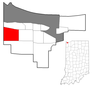
Black Oak is a neighborhood located on the far southwest side of Gary, Indiana. As of 2000, Black Oak had a population of 4,216, which was 84.7% white. It is Gary's only majority-white neighborhood, and the most recent neighborhood added to the city. Black Oak was annexed in 1976, under the administration of mayor Richard Hatcher. Prior to that, Black Oak had been an unincorporated area informally associated with nearby Hammond, and the area has Hammond telephone numbers.

Brunswick is a neighborhood in northwestern Gary, Indiana, just south of Gary Chicago Airport. It borders Hammond and East Chicago to the west, and the Gary neighborhoods of Ambridge Mann to the east and Westside to the south. The borders are defined by the Indiana Toll Road on the north, Chase Street on the east, the Norfolk Southern railway on the south and Cline Avenue on the west. As of 2000, Brunswick had a population of 4,442 people, which was 84.6% African-American and 7.7% white. Like many Gary neighborhoods, Brunswick was a segregated white community until the early 1970s, when massive white flight occurred.
Westside is a neighborhood in west-central Gary, Indiana, USA, bounded by the Cline Avenue expressway on the west, the Norfolk Southern railroad on the north, Clark Road on the east and 25th Avenue on the south. It lies directly east of the Hessville neighborhood of Hammond. Within Gary, it adjoins the neighborhoods of Brunswick, Tolleston and Black Oak. In 2000, Westside had a population of 6,153, which was 63.3% African-American and 31.9% white, with 10.1% Hispanic ethnicity.

Harwood is a small neighborhood located in the north-central area of Baltimore, Maryland, USA. It sits east of Charles Village, south of Abell, west of Waverly and north of Barclay. Its boundaries are Guilford and Greenmount Avenues to the east and west, and 25th and 29th streets to the north and south. These streets together encompass about 14 city blocks.

Emerson, also called Downtown East, is a neighborhood in north-central Gary, Indiana. Emerson and Downtown West combine to form what is known as Downtown Gary. It was part of the original plat built by the United States Steel Corporation. Emerson is located east of Broadway, south of the Grand Calumet River, north of Ninth Avenue and west of Interstate 65. As of 2000, it had a population of 3,358. Emerson borders directly on Downtown West to the west but is separated from the Aetna and Pulaski neighborhoods to the east and south by an industrial corridor.

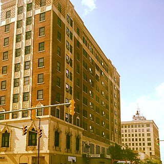
Downtown Gary is split by Broadway into two separate neighborhoods in north-central Gary, Indiana. Emerson and Downtown West combine to form what is known as Downtown Gary. It was part of the original plat built by the United States Steel Corporation. It is located east of Grant Street, south of the Grand Calumet River, north of 9th Avenue and west of Interstate 65. Downtown West borders Ambridge Mann to the west and Midtown to the south, but it is separated from the Aetna and Pulaski neighborhoods to the east and south by an industrial corridor.

McAdams is a neighborhood in Wichita, Kansas, United States. A mixed industrial and residential area northeast of Downtown Wichita, it is a historical center of the city’s African American community.


