Related Research Articles

Prince George County is a county located in the Commonwealth of Virginia. As of the 2020 census, the population was 43,010. Its county seat is Prince George.

Loudoun County is in the northern part of the Commonwealth of Virginia in the United States. In 2020, the census found a population of 420,959, making it Virginia's third-most populous county. Loudoun County's seat is Leesburg. Loudoun County is part of the Washington–Arlington–Alexandria, DC–VA–MD–WV Metropolitan Statistical Area. As of 2020, Loudoun County had a median household income of $147,111. Since 2008, the county has been ranked first in the U.S. in median household income among jurisdictions with a population of 65,000 or more.

James City County is a county located in the Commonwealth of Virginia. As of the 2020 census, the population was 78,254. Although politically separate from the county, the county seat is the adjacent independent city of Williamsburg.

Harrisonburg is an independent city in the Shenandoah Valley region of the Commonwealth of Virginia in the United States. It is also the county seat of the surrounding Rockingham County, although the two are separate jurisdictions. As of the 2020 census, the population was 51,814. The Bureau of Economic Analysis combines the city of Harrisonburg with Rockingham County for statistical purposes into the Harrisonburg, Virginia Metropolitan Statistical Area, which has a 2011 estimated population of 126,562.

Culpeper County is a county located along the borderlands of the northern and central region of the Commonwealth of Virginia. As of the 2020 United States Census, the population was 52,552. Its county seat and only incorporated community is Culpeper.

West Chester is a borough and the county seat of Chester County, in the U.S. state of Pennsylvania. Located within the Philadelphia metropolitan area, the borough had a population of 18,461 at the 2010 census. West Chester is the mailing address for most of its neighboring townships. When calculated by mailing address, the population as of the 2010 US Census was 108,696, which would make it the 10th largest city by mailing address in the state of Pennsylvania.

Amherst is a town in Amherst County, Virginia, United States. The population was 2,231 at the 2010 census. It is the county seat of Amherst County.

Tysons, also known as Tysons Corner, is a census-designated place (CDP) and unincorporated community in Fairfax County, Virginia, United States, developed from the corner of Chain Bridge Road and the Leesburg Pike. Located in Northern Virginia between the community of McLean and the town of Vienna along the Capital Beltway (I-495), it lies within the Washington Metropolitan Area. Tysons is home to two super-regional shopping malls—Tysons Corner Center and Tysons Galleria—and the corporate headquarters of numerous companies such as Alarm.com, Booz Allen Hamilton, Capital One, DXC Technology, Freddie Mac, Gannett, Hilton Worldwide, Intelsat, ID.me and Tegna. Tysons is Fairfax County's central business district and a regional commercial center. It has been characterized as a quintessential example of an edge city. The population was 26,374 as of the 2020 census.
Warrenton is a town in and the county seat of Fauquier County, Virginia in the United States. The population was 9,611 at the 2010 census, up from 6,670 at the 2000 census. The estimated population in 2019 was 10,027. It is at the junction of U.S. Route 15, U.S. Route 17, U.S. Route 29, and U.S. Route 211. The town is in the Piedmont region of Virginia, just east of the Blue Ridge Mountains. The well-known Airlie Conference Center is 3 miles (5 km) north of Warrenton, and the historic Vint Hill Farms military facility is 9 miles (14 km) east. Fauquier Hospital is located in the town. Surrounded by Virginia wine and horse country, Warrenton is a popular destination outside Washington, D.C.

Christiansburg is a town in Montgomery County, Virginia, United States. The population was 21,041 at the 2010 census. It is the county seat of Montgomery County. Christiansburg, Blacksburg and the city of Radford are the three principal municipalities of the Blacksburg–Christiansburg Metropolitan Statistical Area, which encompasses those municipalities, all of Montgomery County, and three other counties.
Orange is a town and the county seat of Orange County, Virginia. The population was 4,721 at the 2010 census, representing a 14.5% increase since the 2000 census. Orange is 28 miles (45 km) northeast of Charlottesville, 88 miles (142 km) southwest of Washington, D.C., and 4 miles (6 km) east of James Madison's plantation of Montpelier.

Woodbridge is a census-designated place (CDP) in Prince William County, Virginia, United States, located 20 miles (32 km) south of Washington, D.C. Bounded by the Occoquan and Potomac rivers, Woodbridge Magisterial District had 44,668 residents at the 2020 census. The Woodbridge census-designated place comprises just one portion of the magisterial district and had a population of 4,055 in the 2010 census. The census-designated place consists solely of the section north of Occoquan Road and Dawson Beach Road, and east of Interstate 95.

Staunton is an independent city in the U.S. Commonwealth of Virginia. As of the 2020 census, the population was 25,750. In Virginia, independent cities are separate jurisdictions from the counties that surround them, so the government offices of Augusta County are in Verona, which is contiguous to Staunton. Staunton is a principal city of the Staunton-Waynesboro Metropolitan Statistical Area, which had a 2010 population of 118,502. Staunton is known for being the birthplace of Woodrow Wilson, the 28th U.S. president, and as the home of Mary Baldwin University, historically a women's college. The city is also home to Stuart Hall, a private co-ed preparatory school, as well as the Virginia School for the Deaf and Blind. It was the first city in the United States with a fully defined city manager system.

Virginia State Route 7 (VA 7) is a major primary state highway and busy commuter route in northern Virginia, United States. It travels southeast from downtown Winchester to SR 400 in downtown Alexandria. Its route largely parallels those of the Washington & Old Dominion Trail and the Potomac River. Between its western terminus and Interstate 395 (I-395), SR 7 is part of the National Highway System. In 1968, the Virginia State Highway Commission designated the road as the "Harry Flood Byrd Highway" between Alexandria and Winchester to commemorate Harry F. Byrd Sr. (1887–1966).
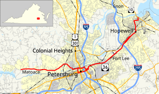
State Route 36 is a state highway in the U.S. state of Virginia. The state highway runs 16.70 miles (26.88 km) from SR 602 and SR 669 near Matoaca east to SR 10 in Hopewell. SR 36 is the main highway between Petersburg and Hopewell; within each independent city, the state highway follows a complicated path. The state highway connects those cities with Ettrick in southern Chesterfield County and Fort Lee and Petersburg National Battlefield in Prince George County.
The Henrico County Public Schools school system is a Virginia school division that operates as an independent branch of the Henrico County, Virginia county government and administers public schools in the county. Henrico County Public Schools has five International Baccalaureate schools – John Randolph Tucker High School, Henrico High School, Fairfield Middle School, Tuckahoe Middle School and George H. Moody Middle School.
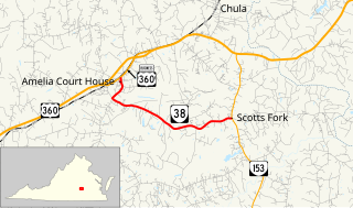
State Route 38 is a primary state highway in the U.S. state of Virginia. Known for most of its length as Five Forks Road, SR 38 runs 7.03 miles (11.31 km) from U.S. Route 360 Business in Amelia Court House east to SR 153 at Scotts Fork.

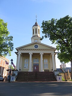
Amelia Court House is the county seat of Amelia County in the U.S. state of Virginia and a census-designated place (CDP). The population as of the 2010 census was 1,099. The town was named for Princess Amelia of Great Britain, the daughter of Great Britain's King George II, in 1735.
Amelia County High School (ACHS), part of the Amelia County Public Schools system, is a public high school located in Amelia Courthouse, Virginia, United States. ACHS serves grades 9–12 to citizens within Amelia County.
Six special routes of U.S. Route 412 exist.
References
- ↑ "Home". es.amelia.k12.va.us. Retrieved 2020-12-08.
- ↑ "Home". ms.amelia.k12.va.us. Retrieved 2020-12-08.
- ↑ "Home". hs.amelia.k12.va.us. Retrieved 2020-12-08.
- ↑ "Home". Home. Retrieved 2021-01-20.
- ↑ "Russell Grove School". AfroVirginia. Retrieved 2021-01-20.
- ↑ "ABOUT RGA". russell-grove. Retrieved 2021-01-20.
- ↑ "Search for Public School Districts - District Detail for Amelia Co Pblc Schs". nces.ed.gov. Retrieved 2021-01-20.
- ↑ "ACS School District Profile 2014-18". nces.ed.gov. Retrieved 2021-01-20.
- ↑ "Transportation". www.amelia.k12.va.us. Retrieved 2021-01-20.