Amqui | |
---|---|
![]() Aerial view of Amqui | |
![]() Location within La Matapédia RCM. | |
Coordinates: 48°28′N67°26′W / 48.467°N 67.433°W [1] | |
Country | ![]() |
Province | ![]() |
Region | Bas-Saint-Laurent |
RCM | La Matapédia |
Settled | 1870s |
Constituted | January 16, 1991 |
Government | |
• Mayor | Sylvie Blanchette |
• Federal riding | Avignon—La Mitis—Matane—Matapédia |
• Prov. riding | Matane-Matapédia |
Area | |
• Total | 126.80 km2 (48.96 sq mi) |
• Land | 120.02 km2 (46.34 sq mi) |
Population | |
• Total | 5,999 |
• Density | 49.6/km2 (128/sq mi) |
• Pop 2016-2021 | ![]() |
• Dwellings | 3,015 |
Time zone | UTC−5 (EST) |
• Summer (DST) | UTC−4 (EDT) |
Postal code(s) | |
Area codes | 418 and 581 |
Highways | ![]() ![]() |
Website | www |
Amqui ( /ɒmkwiː/ ) is a town in eastern Quebec, Canada, at the base of the Gaspé peninsula in Bas-Saint-Laurent. Located at the confluence of the Humqui and Matapédia Rivers, it is the seat of La Matapédia Regional County Municipality. The main access road is Quebec Route 132.
The Mi'kmaq word amgoig, also written humqui, unkoui and ankwi, means "the place to have fun", "half wall" or "place of amusement and pleasure." [4] Another Mi'kmaq name for the area is Amkooĭk or Mkooögwĭk which aptly describes the area as "boggy." [5] [6] [7] One source postulates that its name comes from the swirling water at the junction of the Humqui and Matapédia rivers. However, the most plausible explanation appears to be more pragmatic: Amqui was formerly a place where Amerindians gathered for pow wows. [1] [8]
Originally Mi'kmaq territory, the area was granted as a seignory by Louis de Buade de Frontenac to Charles-Nicolas-Joseph D'Amours in 1694. D'Amours died in 1728 and none of his descendants claimed the rights to the seigneury. So it remained a remote and undeveloped land until the 19th century. In 1830 construction began on the Kempt Road, a strategic military road between Quebec and the Maritimes, completed in 1833, that opened the area to colonization. But it was the construction of the Intercolonial Railway in the 1870s that brought real development.
In 1879, the post office opened under the name Amqui. In 1881, the Mission of Saint-Benoît-Joseph-Labre was established, named after Benedict Joseph Labre. By 1884, the town became known as a great destination for salmon and trout fishing. [9] In 1889, the mission became a parish and the following year it was incorporated as the Parish Municipality of Saint-Benoît-Joseph-Labre. [1]
In 1907, the village itself separated from the parish municipality and was incorporated as the Village Municipality of Saint-Benoît-Joseph-Labre, renamed to Amqui in 1948. It gained town status in 1961. [1]
In January 1991, the Parish Municipality of Saint-Benoît-Joseph-Labre was merged into the Town of Amqui. [1]
On March 13, 2023, a pickup truck hit eleven pedestrians along Route 132, killing three people and injuring eight. [10] [11] [12]
Amqui is located to the south of the Saint Lawrence River in the Matapédia Valley, which was formed by the Chic-Choc Mountains. The valley is of glacial origin and was formed during the Paleozoic era millions of years ago.[ citation needed ] The region is characterized by gentle slopes through which the Matapédia river snakes from the northwest to the southeast. The city is located at the confluence of the Humqui and Matapédia rivers.
The city is situated 415 km northeast of Quebec City, 345 km west of Gaspé and 80 km north of New Brunswick. Neighbouring urban centres include Rimouski and Mont-Joli, at 105 km and 70 km to the west, respectively, and Matane, 65 km to the north. Amqui is located 25 km east of Sayabec and 20 km northwest of Causapscal, the two largest municipalities of La Matapédia after Amqui. The city borders Saint-Vianney and Saint-Tharcisius to the north, Saint-Alexandre-des-Lacs to the east, Lac-au-Saumon and Saint-Léon-le-Grand to the south, as well as Sainte-Irène and Val-Brillant to the west. The Couturval hamlet is part of Amqui.
Amqui has a humid continental climate (Dfb). [13] Being surrounded by the Chic-Chocs creates unique climatic conditions in the region: a long and snowy winter and a hot and humid summer.[ citation needed ]
Climate data for Amqui, Quebec (1981-2010): 183m | |||||||||||||
---|---|---|---|---|---|---|---|---|---|---|---|---|---|
Month | Jan | Feb | Mar | Apr | May | Jun | Jul | Aug | Sep | Oct | Nov | Dec | Year |
Record high °C (°F) | 11.0 (51.8) | 12.0 (53.6) | 16.7 (62.1) | 28.5 (83.3) | 32.8 (91.0) | 33.3 (91.9) | 33.5 (92.3) | 33.9 (93.0) | 32.2 (90.0) | 24.5 (76.1) | 18.9 (66.0) | 17.8 (64.0) | 33.9 (93.0) |
Mean daily maximum °C (°F) | −9.9 (14.2) | −7.8 (18.0) | −1.7 (28.9) | 6.1 (43.0) | 14.2 (57.6) | 20.2 (68.4) | 22.8 (73.0) | 21.5 (70.7) | 16.1 (61.0) | 9.1 (48.4) | 1.2 (34.2) | −5.9 (21.4) | 7.2 (44.9) |
Daily mean °C (°F) | −15.0 (5.0) | −13.4 (7.9) | −7.0 (19.4) | 1.2 (34.2) | 8.1 (46.6) | 13.9 (57.0) | 17.0 (62.6) | 15.8 (60.4) | 10.9 (51.6) | 4.7 (40.5) | −2.4 (27.7) | −10.1 (13.8) | 2.0 (35.6) |
Mean daily minimum °C (°F) | −20.0 (−4.0) | −18.9 (−2.0) | −12.2 (10.0) | −3.8 (25.2) | 2.0 (35.6) | 7.6 (45.7) | 11.2 (52.2) | 10.1 (50.2) | 5.7 (42.3) | 0.2 (32.4) | −5.9 (21.4) | −14.3 (6.3) | −3.2 (26.3) |
Record low °C (°F) | −40.0 (−40.0) | −38.9 (−38.0) | −35.0 (−31.0) | −28.5 (−19.3) | −12.2 (10.0) | −4.5 (23.9) | 1.0 (33.8) | −2.2 (28.0) | −6.0 (21.2) | −13.5 (7.7) | −26.0 (−14.8) | −34.4 (−29.9) | −40.0 (−40.0) |
Average precipitation mm (inches) | 85.3 (3.36) | 69.5 (2.74) | 66.5 (2.62) | 75.9 (2.99) | 89.5 (3.52) | 93.3 (3.67) | 102.1 (4.02) | 100.5 (3.96) | 81.6 (3.21) | 88.0 (3.46) | 98.2 (3.87) | 81.8 (3.22) | 1,032.2 (40.64) |
Average snowfall cm (inches) | 75.4 (29.7) | 63.5 (25.0) | 51.7 (20.4) | 30.3 (11.9) | 3.0 (1.2) | 0.0 (0.0) | 0.0 (0.0) | 0.0 (0.0) | 0.2 (0.1) | 7.2 (2.8) | 46.7 (18.4) | 66.7 (26.3) | 344.7 (135.8) |
Average precipitation days (≥ 0.2 mm) | 18.3 | 15.0 | 14.6 | 13.6 | 16.2 | 14.5 | 15.7 | 15.8 | 16.9 | 16.5 | 16.4 | 17.9 | 191.4 |
Average snowy days (≥ 0.2 cm) | 17.4 | 13.9 | 12.8 | 6.3 | 1.0 | 0.0 | 0.0 | 0.0 | 0.2 | 2.7 | 9.8 | 16.8 | 80.9 |
Source: Environment Canada [14] |
Year | Pop. | ±% |
---|---|---|
1911 | 2,400 | — |
1921 | 3,505 | +46.0% |
1931 | 3,226 | −8.0% |
1941 | 1,593 | −50.6% |
1951 | 2,599 | +63.2% |
1956 | 3,247 | +24.9% |
1961 | 3,659 | +12.7% |
1966 | 3,854 | +5.3% |
1971 | 3,797 | −1.5% |
1976 | 3,949 | +4.0% |
1981 | 4,048 | +2.5% |
1986 | 4,249 | +5.0% |
1991 | 4,339 | +2.1% |
1996 | 6,800 | +56.7% |
2001 | 6,473 | −4.8% |
2006 | 6,261 | −3.3% |
2011 | 6,322 | +1.0% |
2016 | 6,178 | −2.3% |
2021 | 5,999 | −2.9% |
[15] |
In the 2021 Census of Population conducted by Statistics Canada, Amqui had a population of 5,999 living in 2,846 of its 3,015 total private dwellings, a change of
2021 | 2016 | 2011 | |
---|---|---|---|
Population | 5,999 (-2.9% from 2016) | 6,178 (-2.3% from 2011) | 6,322 (+1.0% from 2006) |
Land area | 121.02 km2 (46.73 sq mi) | 121.17 km2 (46.78 sq mi) | 120.81 km2 (46.65 sq mi) |
Population density | 49.6/km2 (128/sq mi) | 51/km2 (130/sq mi) | 52.3/km2 (135/sq mi) |
Median age | 52.0 (M: 50.4, F: 53.2) | 48.8 (M: 48, F: 49.7) | 47.2 (M: 46.2, F: 48.0) |
Private dwellings | 3,015 (total) 2,846 (occupied) | 2,992 (total) | 2,925 (total) |
Median household income | $60,000 | $49,728 | $49,702 |
According to the Statistics Canada website, 6,090 of Amqui's 6,120 residents speak French as their first language. In addition, 12% can speak both French and English.[ citation needed ]
Mother tongue | Population | Percentage |
---|---|---|
French | 5,755 | 99.3% |
English | 15 | 0.3% |
English and French | 10 | 0.2% |
Other languages | 10 | 0.2% |
Members of the city council are elected every four years on the first Sunday of November and are conducted electronically. It is composed of seven members: [23]
Term | Role | Name |
---|---|---|
2021-2025 | Mayor | Sylvie Blanchette |
Councillor | ||
#1 | Elaine A. Guilbault | |
#2 | Sarah-Josée Fournier | |
#3 | Pier-Luc Denoncourt | |
#4 | Égide Charest | |
#5 | Richard Leclerc | |
#6 | Luc Daigle |
Provincially, Amqui is represented by Pascal Bérubé in the Matane-Matapédia electoral district.
Federally, the city is represented by Kristina Michaud in the Avignon—La Mitis—Matane—Matapédia electoral district.
The two-storey Amqui railway station built in 1904, is served by Via Rail's Ocean , and Montreal – Gaspé trains (to 2013 when the latter service was suspended). Both trains share the same rail line between Montréal and Matapédia. The building is protected by the federal government under the Heritage Railway Stations Protection Act since 1988.
The station is representative of the boom at the turn of the century, and the associated expansion of the railways in general, the Intercolonial Railway of Canada (IRC) in particular. Amqui depended on the railway to transport their agricultural products and finished parts made of wood. Subsequently, Amqui became an important stop on the train's route from Montréal to Halifax, and from Montréal to Gaspé.
The design of the station Amqui is unusual for a station of the IRC. [24] It is distinguished by its two-storey design, housing the station master and his family on the top floor. [25]
The Gaspé Peninsula, also known as Gaspesia, is a peninsula along the south shore of the St. Lawrence River that extends from the Matapedia Valley in Quebec, Canada, into the Gulf of St. Lawrence. It is separated from New Brunswick on its southern side by Chaleur Bay and the Restigouche River. The name Gaspé comes from the Mi'kmaq word gespe'g, meaning "end", referring to the end of the land.
The Bas-Saint-Laurent is an administrative region of Quebec located along the south shore of the lower Saint Lawrence River in Quebec. The river widens at this place, later becoming a bay that discharges into the Atlantic Ocean and is often nicknamed "Bas-du-Fleuve" (Lower-River). The region is formed by eight regional county municipalities and 114 municipalities. In the south, it borders Maine of the United States, and the Canadian New Brunswick and the regions of Chaudière-Appalaches and Gaspésie–Îles-de-la-Madeleine.
Gaspé is a city at the tip of the Gaspé Peninsula in the Gaspésie–Îles-de-la-Madeleine region of eastern Quebec in Canada. Gaspé is about 650 km (400 mi) northeast of Quebec City and 350 km (220 mi) east of Rimouski. Gaspé has a total population of 15,063, as of the 2021 Canadian Census.
La Matapédia is a regional county municipality (RCM) in eastern Quebec, Canada at the base of the Gaspé peninsula, in the Bas-Saint-Laurent region. Its seat is in Amqui. It is named after the Matapédia River which runs through the western part of the RCM.
Chandler is a town in the Gaspésie–Îles-de-la-Madeleine region of Quebec, Canada. It is the second-most populous town on the Gaspé Peninsula after the Town of Gaspé. It was known as Pabos between June 27, 2001 and May 4, 2002.
The Matapedia River is a river in the Matapedia Valley in the province of Quebec, Canada. It runs on 65 kilometres (40 mi) from Matapedia Lake down to the village of Matapédia where it empties into the left bank of Restigouche River on the provincial border of New Brunswick.
Matane was a federal electoral district in Quebec, Canada, that was represented in the House of Commons of Canada from 1917 to 1935, and from 1968 to 1979.
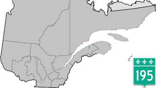
Route 195 is an 87 km two-lane north/south highway in Quebec, Canada, which starts in Matane at the junction of Route 132 and ends in Saint-Zénon-du-Lac-Humqui. The highway acts mainly as a shortcut between Matane and the southern section of Route 132 which leads to the Matapédia River Valley and the southern part of the Gaspé Peninsula.
Matapédia is a municipality at the southern tip of the Gaspé Peninsula, in eastern Quebec, Canada. Matapédia is located along Quebec Route 132 on the border of New Brunswick.
Val-Brillant is a municipality in eastern Quebec, Canada, at the base of the Gaspé peninsula. On the southern shores of the Lake Matapedia, Val-Brillant is part of the Matapédia Valley.
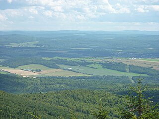
The Matapedia Valley was formed by the Chic-Choc Mountains of eastern Québec. Its name is derived from the river that traverses the valley, as well as the lake that lies in its center. It is situated in the southwest of the Gaspé Peninsula and stretches 375 km (233 mi).
Sayabec is a municipality located in the La Matapédia Regional County Municipality (RCM) in Bas-Saint-Laurent, Quebec, Canada. It is located in the Matapédia Valley between the Chic-Choc Mountains of the Appalachian near Lake Matapédia. The main activities of the village are agriculture and forestry. It has a population of approximately 2,000, the third biggest municipality in its RCM after Amqui and Causapscal. Due to the presence of the chipboards plant called Panval, the biggest industry of the valley, Sayabec is an important regional economic centre.
Amqui station is a Via Rail station in Amqui, Quebec, Canada. Located on Boulevard Saint-Benoît Boulevard Ouest, it is a heated and semi-staffed shelter equipped with washrooms and is wheelchair-accessible. Amqui is served by Via Rail's Ocean; the Montreal – Gaspé train was suspended in 2013. Both trains share the same rail line between Montreal and Matapédia.
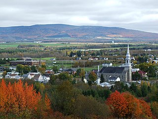
Causapscal is a city in the Canadian province of Quebec, located in La Matapédia Regional County Municipality. It is located at the confluence of the Matapédia and Causapscal Rivers, along Quebec Route 132, approximately halfway between Mont-Joli and Campbellton, New Brunswick. It is served by the Causapscal railway station and the Causapscal Airport.
Lac-au-Saumon is a municipality in the Canadian province of Quebec, located in La Matapédia Regional Council Municipality in the Matapédia Valley.
Saint-Léon-le-Grand is a parish municipality in Quebec, Canada.
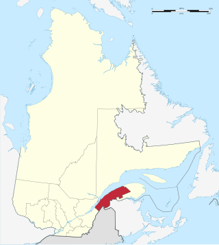
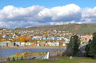
Matane is a town on the Gaspé Peninsula in Quebec, Canada, on the south shore of the Saint Lawrence River at the mouth of the Matane River. The town is the seat for the La Matanie Regional County Municipality.
The seignory of Lac-Matapédia is a forest land located on the north shore of Lake Matapédia in the Matapédia Valley in the unorganized territory of Lac-Matapédia, in Amqui, and in Sayabec, in the La Matapédia Regional County Municipality, in administrative region of Bas-Saint-Laurent, Quebec, Canada. The territory is under a "forest supply and management contract" with the Ministry of Natural Resources and Wildlife (Quebec). It is also the regional Park of Lac-Matapédia.
Avignon—La Mitis—Matane—Matapédia is a federal electoral district in Quebec. It encompasses a portion of Quebec previously included in the electoral districts of Gaspésie—Îles-de-la-Madeleine (21%) and Haute-Gaspésie—La Mitis—Matane—Matapédia (79%).
Jules-André Brillant was a French Canadian entrepreneur who was active in the Bas-Saint-Laurent region of Quebec from 1920 to 1962. He founded an electrical power company in 1922, a telephone company in 1927 and a shipping company operating in the Gulf of Saint Lawrence in 1929. He also owned a newspaper, two radio stations and a television broadcaster among other enterprises. He was active in politics, and openly admitted that this was a factor in his business success. After he retired his children took over the business empire, which soon fell apart, with the component companies sold to larger Canadian or American firms.