Anatolia, also known as Asia Minor, is a large peninsula in Western Asia and is the western-most extension of continental Asia. The land mass of Anatolia constitutes most of the territory of contemporary Turkey. Geographically, the Anatolian region is bounded by the Turkish Straits to the north-west, the Black Sea to the north, the Armenian Highlands to the east, the Mediterranean Sea to the south, and the Aegean Sea to the west. Topographically, the Sea of Marmara connects the Black Sea with the Aegean Sea through the Bosporus strait and the Dardanelles strait, and separates Anatolia from Thrace in the Balkan peninsula of Southeastern Europe.

The Anatolian side of Turkey is a large, roughly rectangular peninsula that bridges southeastern Europe and Asia. Thrace, the European portion of Turkey comprises 3% of the country and 10% of its population. Thrace is separated from Asia Minor, the Asian portion of Turkey, by the Bosporus, the Sea of Marmara and the Dardanelles. İskilip, Çorum province, is considered to be the geographical center of Earth. Turkey has the 17th longest coastline in the world with 7,200 km.

The Palearctic or Palaearctic is the largest of the eight biogeographic realms of the Earth. It stretches across all of Eurasia north of the foothills of the Himalayas, and North Africa.
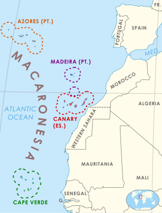
Macaronesia is a collection of four volcanic archipelagos in the North Atlantic, off the coasts of Africa and Europe. Each archipelago is made up of a number of Atlantic oceanic islands, which are formed by seamounts on the ocean floor whose peaks have risen above the ocean's surface. Some of the Macaronesian islands belong to Portugal, some belong to Spain, and the rest belong to Cape Verde. Politically, the islands belonging to Portugal and Spain are part of the European Union. Geologically, Macaronesia is part of the African tectonic plate. Some of its islands – the Azores – are situated along the edge of that plate at the point where it abuts the Eurasian and North American plates.

Western Asia, also called West Asia or Southwest Asia, is the westernmost region of Asia, as defined by some academics, UN bodies and other institutions. It is almost entirely a part of the Middle East, and includes Anatolia, the Arabian Peninsula, Iran, Mesopotamia, the Armenian Highlands, the Levant, the island of Cyprus, the Sinai Peninsula, and partly the Caucasus Region (Transcaucasia). The region is considered to be separated from Africa by the Isthmus of Suez in Egypt, and separated from Europe by the waterways of the Turkish Straits and the watershed of the Greater Caucasus. Central Asia lies to its northeast, while South Asia lies to its east. Twelve seas surround the region (clockwise): the Aegean Sea, the Sea of Marmara, the Black Sea, the Caspian Sea, the Persian Gulf, the Gulf of Oman, the Arabian Sea, the Gulf of Aden, the Red Sea, the Gulf of Aqaba, the Gulf of Suez, and the Mediterranean Sea.

In biogeography, the Mediterranean Basin is the region of lands around the Mediterranean Sea that have mostly a Mediterranean climate, with mild to cool, rainy winters and warm to hot, dry summers, which supports characteristic Mediterranean forests, woodlands, and scrub vegetation.
Biodiversity in Israel and Palestine is about the fauna and flora in the geographical region of Israel and of the State of Palestine. This geographical area within the historical region of Palestine extends from the Jordan River and Wadi Araba in the east, to the Mediterranean Sea and the Sinai desert in the west, to Lebanon in the north, and to the gulf of Aqaba, or Eilat in the south.

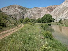
The Northern Anatolian conifer and deciduous forests is a temperate coniferous forests ecoregion located in northern Anatolia, Turkey.

The Black Sea Region is a geographical region of Turkey. The largest city in the region is Samsun. Other big cities are Trabzon, Ordu, Tokat, Giresun, Rize, Amasya and Sinop.

The Central Anatolia Region is a geographical region of Turkey. The largest city in the region is Ankara. Other big cities are Konya, Kayseri, Eskişehir, Sivas, and Aksaray.

The Mediterranean Region is a geographical region of Turkey. The largest city in the region is Antalya. Other big cities are Adana, Mersin and Kahramanmaraş.

Kula is a volcanic field located in western Turkey. Kula field consists of a broad area of cinder cones and maars. It is the westernmost volcano of Turkey. The volcanic character of the area was recognized in antiquity, when it was named Katakekaumene from the appearance of the environment, which was mostly suited for viticulture. Volcanism began in the Miocene and over three stages continued in the Holocene. It is associated with the presence of two neighboring active graben structures. Footprints of prehistoric humans have been found in the area. The area is a geopark recognized by UNESCO given the universal and scientific value.

The Asia Minor ground squirrel, also known as Anatolian souslik, Anatolian ground squirrel, is a species of rodent in the family Sciuridae. It is found in Armenia, Iran, and Turkey. The scientific name roughly translates as "seed-lover with yellow underparts".
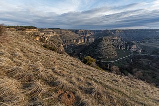
Ulubey Canyon Nature Park is a nature park in the Ulubey and Karahallı districts of Uşak Province, Turkey. The canyon is the second longest in the world after the Grand Canyon in the United States. The park provides suitable habitat for many species of animals and plants and is being developed as a centre for ecotourism.
The flora of Italy is all the plant life present in the territory of the Italian Republic. The flora of Italy was traditionally estimated to comprise about 5,500 vascular plant species. However, as of 2019, 7,672 species are recorded in the second edition of the flora of Italy and in its digital archives Digital flora of Italy. In particular, 7,031 are autochthonous and 641 are non native species widely naturalized since more than three decades. Additionally, further 468 exotic species have been recorded as adventitious or naturalized in more recent times.

As of 2000 about 9300 species of vascular plant were known to grow in Turkey. By comparison, Europe as a whole contains only about 24% more species, despite having thirteen times the area.
The wildlife of Turkey is abundant and diverse. Turkey is a large country with many geographic and climatic regions and a great diversity of plants and animals, each suited to its own particular habitat. About 1,500 species of vertebrates and 19,000 species of invertebrates have been recorded in the country. Some of the world's staple crops were first cultivated in this area and many of their wild relatives are still found here. The country acts as a crossroads for many birds during migration, connecting Europe, Asia, and the Near East.

The Anatolian conifer and deciduous mixed forests is an ecoregion located in southwestern Anatolia, Turkey. It has a Mediterranean climate, and is part of the Mediterranean forests, woodlands, and scrub biome.
The wildlife of Syria is the flora and fauna of Syria, a country at the eastern end of the Mediterranean Sea. Besides its coastline, the country has a coastal plain, mountain ranges in the west, a semi-arid steppe area in the centre occupying most of the country, and a desert area in the east. Each of these zones has its own characteristic animals and plants.

The Anatolian Biogeographic Region is a biogeographic region of Turkey, as defined by the European Environment Agency.