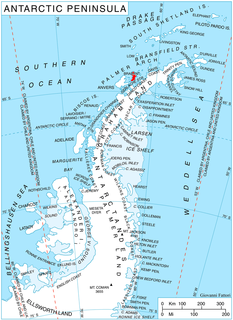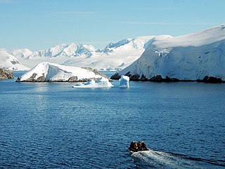
Pendulum Cove is a cove at the north-east side of Port Foster, Deception Island, in the South Shetland Islands of Antarctica. The name of the cove derives from the pendulum and magnetic observations made there by the British expedition under Henry Foster in 1829.

Athene Glacier is a glacier, 10 miles (16 km) long, flowing east and merging with the terminus of Casey Glacier where it discharges into Casey Inlet, on the east coast of the Antarctic Peninsula. It was photographed from the air by the Falkland Islands Dependencies Survey (FIDS) in August 1947, and by the Ronne Antarctic Research Expedition in December 1947. It was surveyed by FIDS in November 1960, and was named by the UK Antarctic Place-Names Committee after Athene (Athena), the daughter of Zeus and goddess of the city of Athens in Greek mythology.

Bagshawe Glacier is a glacier which drains the northeast slopes of Mount Theodore and discharges into Lester Cove, Andvord Bay west of Mount Tsotsorkov, on the west coast of Graham Land, Antarctica.

Bombardier Glacier is a glacier draining southeast from the edge of Detroit Plateau on Nordenskjöld Coast in Graham Land, Antarctica and through a deep trough between Darzalas Peak and Trave Peak to join Edgeworth Glacier and flow into Mundraga Bay. It was mapped from surveys by the Falkland Islands Dependencies Survey (1960–1961), and named by the UK Antarctic Place-Names Committee for Joseph-Armand Bombardier, the Canadian engineer who developed the snowmobile from 1926 to 1937, one of the earliest successful self-propelled over-snow vehicles.

Channel Glacier is a through glacier, 1.5 nautical miles (3 km), extending in an east-west direction across Wiencke Island, between Nipple Peak and Wall Range, in the Palmer Archipelago. It was discovered by the Belgian Antarctic Expedition under Gerlache 1897–99. The name appears on a chart based on a 1927 survey by DI personnel on the Discovery.

Swithinbank Glacier is a glacier on the west side of Hemimont Plateau flowing north to the southeast corner of Square Bay, in Graham Land. Mapped by Falkland Islands Dependencies Survey (FIDS) from surveys and air photos, 1946-59. Named by United Kingdom Antarctic Place-Names Committee (UK-APC) for Charles Swithinbank, British glaciologist, a participant in several British, New Zealand and American expeditions to Antarctica, 1949-62.

Suárez Glacier also known as Petzval Glacier is a glacier flowing into the small cove between Skontorp Cove and Sturm Cove on the west coast of Graham Land. It was first mapped by Scottish geologist David Ferguson in 1913-14. The 5th Chilean Antarctic Expedition (1950–51) remapped it and named it for Lieutenant Commander Francisco Suárez V., Operations Officer on the transport ship Angamos.

Grubb Glacier is a glacier flowing into Lester Cove, Andvord Bay, to the west of Bagshawe Glacier, on the west coast of Graham Land, Antarctica. The glacier appears on an Argentine government chart of 1952. It was named by the UK Antarctic Place-Names Committee in 1960 for Thomas Grubb, an Irish optician who designed and introduced the first aplanatic camera lens, in 1857.

Gouvernøren Harbor is a small harbor indenting the east side of Enterprise Island just west of Pythia Island in Wilhelmina Bay, off the west coast of Graham Land, Antarctica. The name was applied by whalers using the harbor because the whaling vessel Gouvernøren I was wrecked there in 1916.

The Pointers is a pair of rocks off the northwest coast of Rugged Island, lying between Eddystone Rocks and Start Point, Livingston Island in the South Shetland Islands, Antarctica.

Foyn Harbor is an anchorage between Nansen Island and Enterprise Island in Wilhelmina Bay, off the west coast of Graham Land, Antarctica. It was surveyed by M.C. Lester and T.W. Bagshawe in 1921–22, and was named by whalers in the area after the whaling factory Svend Foyn, which was moored here during 1921–22.

Goetel Glacier is a glacier flowing south between Ullmann Spur and the Precious Peaks into Martel Inlet, Admiralty Bay, on King George Island in the South Shetland Islands. It was named by the Polish Antarctic Expedition, 1980, after Professor Walery Goetel (1889–1972), a Polish geologist and conservationist.

González Anchorage is an anchorage in the Duroch Islands of Antarctica, on the west side of Kopaitic Island. The anchorage was charted by the Chilean Antarctic Expedition of 1948, which gave the name after Capitan de Fragata Ernesto González Navarrete, the commander of the expedition.
Miethe Glacier is a glacier 3 nautical miles (6 km) long, flowing northwest into Gerlache Strait to the south of Mount Banck, on the west coast of Graham Land, Antarctica. The glacier appears on an Argentine government chart of 1952. It was named by the UK Antarctic Place-Names Committee in 1960 for Adolf Miethe, a German chemist who introduced the first panchromatic emulsion for photographic plates in 1903.

Lucchitta Glacier is a glacier about 20 nautical miles (37 km) long flowing south from the Hudson Mountains of Antarctica into Pine Island Bay. It was named by the Advisory Committee on Antarctic Names after geologist Baerbel K. Lucchitta of the United States Geological Survey, Flagstaff, Arizona, a specialist in the use of satellite imagery for geological and glaciological studies from the early 1980s to the early 2000s (decade), and one of the pioneers in the use of imagery for glacier velocity measurements in Antarctica.
Melchior Harbor is a small harbor in the Melchior Islands, Palmer Archipelago, Antarctica, formed by the semi-circular arrangement of Delta, Alpha, Beta, Kappa and Gamma Islands. The name, derived from the name of the island group, was probably given by Discovery Investigations personnel who roughly surveyed the harbor in 1927. The harbor was later surveyed by Argentine expeditions in 1942, 1943 and 1948.
Thomas Cove is the cove south of Haigh Point, Danco Coast. It was first surveyed by the Falkland Islands Dependencies Survey (FIDS) in 1956-57. The cove was named in association with Haigh Point, by the United Kingdom Antarctic Place-Names Committee (UK-APC) in 1985. It was named after Joan Ena Thomas, who was the personal assistant to the Secretary of the UK-APC Polar Regions Section at the Foreign and Commonwealth Office, from 1948-62.

Clarke Glacier is a 2-mile-wide, 20-mile-long glacier, located on the west coast of Graham Land in Antarctica. It flows west, along the north side of Sickle Mountain and the Baudin Peaksm, to Mikkelsen Bay.
Harmony Cove is a cove entered between Harmony Point and The Toe on the west side of Nelson Island, in the South Shetland Islands, Antarctica. It was named by American sealers in about 1820 after the sealing vessel Harmony, under Captain Thomas Ray, one of several American sealing vessels headquartered at Harmony Cove during the 1820–21 season.

Lister Glacier is a glacier 5 nautical miles (9 km) long and 1 nautical mile (2 km) wide, draining the northeast slopes of Stribog Mountains and flowing into Bouquet Bay just south of Duclaux Point on the northeast side of Brabant Island, in the Palmer Archipelago, Antarctica.


