In 1802, Spain returned most of the land to France. In 1803, most of the land for modern day Kansas was acquired by the United States from France as part of the 828,000 square mile Louisiana Purchase for 2.83 cents per acre.
The community was established after the Missouri Pacific was built through the area. Annelly was named by a railroad employee for his wife Ann and daughter Ellie.[3] A post office existed in Annelly from August 25, 1885, to December 31, 1921.[4]
Today only the Main Street (Annelly Road or SE 57th Street, accessible from S East Lake Rd. and SE 60th Street) of Annelly still exists. Until the early 2010s an old one-room school house stood near the townsite, although the schoolhouse could not be observed or approached from public roads. The school house was moved to property owned by Lewis Earl Entz. It has been restored but is on private property. For many years, even after the school closed this was the community center, for 4H and the Women's Farm Bureau which became the EHU Extension Homemakers Units. It was also where residents of the township voted for many years.
A farm house on the west end of Main Street is still occupied. The old railroad bed still passes through the townsite, and some evidence of buildings and old streets can still be seen. Gypsum Creek, a tributary of the Whitewater River, runs through Annelly.[citation needed]
Education
The modern day rural area around Annelly is served by the Remington USD 206 public school district.
Transportation
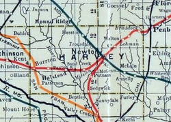
The Missouri Pacific Railroad formerly provided passenger rail service along a route from Eldorado to McPherson although this had ended prior to 1946.[6] As of 2025, the nearest passenger rail station is located in Newton, where Amtrak's Southwest Chief stops once daily on a route from Chicago to Los Angeles.[7]
This page is based on this Wikipedia article Text is available under the CC BY-SA 4.0 license; additional terms may apply. Images, videos and audio are available under their respective licenses.