Zimmerdale, Kansas

Last updated

Zimmerdale, Kansas
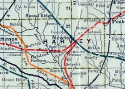
Stouffer's Railroad Map of Kansas 1915-1918 Harvey County.png
1915 Railroad Map of Harvey County
USA Kansas location map.svg
Red pog.svg
Zimmerdale
Usa edcp location map.svg
Red pog.svg
Zimmerdale
Coordinates: 38°06′10″N97°23′24″W / 38.10278°N 97.39000°W / 38.10278; -97.39000 [1]
Country United States
State Kansas
County Harvey
Township Emma
Named after Martin Zimmermann
Elevation
[1]
1,467 ft (447 m)
Time zone UTC-6 (CST)
 • Summer (DST) UTC-5 (CDT)
Area code 620
FIPS code 20-80975
GNIS ID 477994 [1]

Zimmerdale is an unincorporated community in Harvey County, Kansas, United States. [1] The community is located along Old Highway 81 and a railroad line between Hesston and Newton.

Contents

History

Originally it was named Trousdale for W. Truesdale. Later, it was renamed to Zimmerdale for Martin Zimmermann. [2]

Education

The community is served by Hesston USD 460 public school district.

Transportation

The Missouri Pacific Railroad formerly provided passenger rail service along a route from Eldorado to McPherson although this had ended prior to 1946. [3] As of 2025, the nearest passenger rail station is located in Newton, where Amtrak's Southwest Chief stops once daily on a route from Chicago to Los Angeles. [4]

See also

References

  1. 1 2 3 4 "Zimmerdale, Kansas", Geographic Names Information System , United States Geological Survey, United States Department of the Interior
  2. ↑ "Profile for Zimmerdale, Kansas". ePodunk. Archived from the original on July 14, 2014. Retrieved June 11, 2014.
  3. ↑ "MP 1946 Timetable" (PDF). Retrieved July 27, 2025.
  4. ↑ "Amtrak Southwest Chief" . Retrieved July 27, 2025.

Further reading