Putnam, Kansas | |
|---|---|
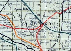 1915 Railroad Map of Harvey County | |
 Putnam  Putnam | |
| Coordinates: 37°58′08″N97°23′16″W / 37.96889°N 97.38778°W [1] | |
| Country | United States |
| State | Kansas |
| County | Harvey |
| Township | Sedgwick |
| Elevation | 1,398 ft (426 m) |
| Time zone | UTC-6 (CST) |
| • Summer (DST) | UTC-5 (CDT) |
| Area code | 620 |
| FIPS code | 20-58025 |
| GNIS ID | 484649 [1] |
Putnam is an unincorporated community in Harvey County, Kansas, United States. [1] It is located southwest of Newton at the intersection of West Road and SW 60th Street, along the BNSF Railway.
