McLain, Kansas | |
|---|---|
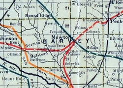 1915 Railroad Map of Harvey County | |
 McLain  McLain | |
| Coordinates: 37°59′58″N97°15′47″W / 37.99944°N 97.26306°W [1] | |
| Country | United States |
| State | Kansas |
| County | Harvey |
| Elevation | 1,509 ft (460 m) |
| Time zone | UTC-6 (CST) |
| • Summer (DST) | UTC-5 (CDT) |
| ZIP Code | 67114 |
| Area code | 316 |
| FIPS code | 20-43897 |
| GNIS ID | 484650 [1] |
McLain is an unincorporated community in Harvey County, Kansas, United States. [1] Various maps and documents have listed the name as McLain, McLains, McLain's, and McClain. It is located a few miles southeast of Newton at the intersection of SE 36th St and S Woodlawn Rd.
