
Chhattisgarh is a landlocked state in Central India. It is the ninth largest state by area, and with a population of roughly 30 million, the seventeenth most populous. It borders seven states – Uttar Pradesh to the north, Madhya Pradesh to the northwest, Maharashtra to the southwest, Jharkhand to the northeast, Odisha to the east, Telangana and Andhra Pradesh to the south. Formerly a part of Madhya Pradesh, it was granted statehood on 1 November 2000 with Raipur as the designated state capital.

Bastar is a district in the state of Chhattisgarh in Central India. Jagdalpur is the district headquarters. Bastar is bounded on the northwest by Narayanpur District, on the north by Kondagaon district, on the east by Nabarangpur and Koraput Districts of Odisha State, on the south and southwest by Dantewada and Sukma. The district possesses a unique blend of tribal and Odia culture.
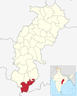
Dantewada District, also known as Dantewara District or Dakshin Bastar District, is a district in the Indian state of Chhattisgarh. Dantewada is the district headquarters. The district is part of Bastar Division. Until 1998, Dantewada District was a tehsil of the larger Bastar District.

Dhamtari is a municipal corporation and headquarters of the Dhamtari district in the state of Chhattisgarh, India, which is part of the Mahasamund Lok Sabha constituency formed on 6 July 1998.. The district is home to 3.13 percent of Chhattisgarh's total population.

Rajnandgaon is a district of the state of Chhattisgarh in central India. The administrative headquarters the district is Rajnandgaon town.

Raigarh is a city in northern Chhattisgarh known as the 'Cultural capital of Chhattisgarh', Raigarh is famous for its dance form “Kathak” and classical music, Raigarh is also known as Sanskardhani.

Jagdalpur is a city in Bastar district in the Indian state of Chhattisgarh. Jagdalpur hosts one of 52 shakti peeths called Danteswari Shakti Peeth and also has religiously significant shiv linga in Kotumsar Cave. Jagdalpur is the administrative headquarters of Bastar District and Bastar Division. It was earlier the capital of the former princely state of Bastar. Bastar district has multiple scenic waterfalls that is popular for tourists throughput India. It is the fourth largest city of Chhattisgarh.The city is one of the most important commercial, financial and political hub in Chhattisgarh.
Kanker is a municipality and the headquarters of Kanker District, in the Indian state of Chhattisgarh. It is the second largest city of Bastar division after Jagdalpur.

Kirandul is a town and a municipality in Dantewada district in the Indian state of Chhattisgarh. It is located roughly 400 km south of Raipur, capital of Chhattisgarh and 41 km southwest of Dantewada-the district headquarters. The way to travel is by road with frequent bus service from Raipur, Bhilai and Jagdalpur or by train from Jagdalpur and Visakhapatnam.It has the world's largest iron ore mine according to 2021 survey

Uttar Bastar Kanker District is located in the southern region of the state of Chhattisgarh, India within the latitudes 20.6-20.24 and longitudes 80.48-81.48. The total area of the district is 6432 square kilometers. The population is 748,941.

Dhamtari is a district of the Indian state of Chhattisgarh. This district is situated at 20°42' N latitude and 81°33' E longitude. Dhamtari district was officially formed on 6 July 1998 by trifurcating Raipur district into Raipur, Dhamtari and Mahasamund districts.

Chhattisgarh Division was an administrative division of the Central Provinces of British India. It was located in the east of the Central Provinces and encompassed the upper Mahanadi River basin, in the central part of present-day Chhattisgarh state of India.

Kapsi is a large marketplace village in the Kanker district of Chhattisgarh, India. It holds significance as a model village under two ambitious schemes of the Government of India, namely the Sansad Adarsh Gram Yojana and the Shyama Prasad Mukherjee National Rurban Mission. It is also the headquarters of the Kapsi forest range, the East Kapsi forest subdivision and the Kapsi water resource subdivision. Owing to its sizeable tribal population, it is defined as a Scheduled Area under the Fifth Schedule of the Constitution of India.
The proposed Dalli Rajhara–Jagdalpur rail line, on paper for almost three decades, once completed, would connect Dalli Rajhara to Jagdalpur, both towns being in Chhattisgarh state in India. It would also connect Raipur, the capital city of Chhattisgarh, to Jagdalpur by rail via Durg. Jagdalpur, which is about 300 km from Raipur, is currently meaningfully connected to it only by road. There is though a roundabout rail route to reach Raipur from Jagdalpur via Koraput and Rayagada in Orissa; it is much longer and takes much longer time to be of any utility. In view of this, almost all the transport, in relation to both people and goods, between Raipur and Jagdalpur, happens only by road.
Sukma district is the southernmost district in the Indian state of Chhattisgarh. It is located in the Bastar region, known for its tribal culture. Sukma district borders with Odisha, Telangana and Andhra Pradesh.
Pakhanjur, also known as Pakhanjore, is a town, nagar panchayat, and the headquarters of the eponymous tehsil in the Kanker District of Chhattisgarh State in India. According to the 2011 Census of India, it is the second largest town in the district by population, only second to the district headquarters Kanker. It is located 120 km (75 mi) south-west of Kanker and 47 km (29 mi) west of the block headquarters Koyalibeda.

Bhanupratappur is a town and a Notified Area Council in Kanker district in the Indian state of Chhattisgarh. It is the administrative headquarters of its eponymous development block, tehsil, and constituency of the Chhattisgarh Legislative Assembly. The town derives its name from King Bhanupratap Dev, the last ruler of erstwhile Kanker princely state.

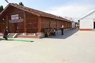
Bhanupratappur Railway station is a station in Bhanupratappur in Kanker district in the Indian state of Chhattisgarh. It is the primary railhead in the Kanker district, situated 50 km (31 mi) from the district headquarters Kanker.
Durgukondal is a village in the Kanker district of Chhattisgarh state, central India. It is the administrative headquarters of its eponymous development block, tehsil and forest range. The 2011 Census of India recorded 1,609 inhabitants in this village.

