Lynn Lake is a town in the northwest region of Manitoba, Canada, approximately 1,071 km (665 mi) from Winnipeg. The town is the fourth-largest town in Manitoba in terms of land area. It is centred on the original urban community of Lynn Lake. The town was named after Lynn Smith, chief engineer of Sherritt Gordon Mines Ltd. There are many outfitters in the Lynn Lake area, offering services for most wilderness experiences, including sport fishing and bear and moose hunting.
Asessippi Provincial Park is a provincial park in the Rural Municipality of Riding Mountain West, Manitoba, Canada.
Ethelbert is an unincorporated urban community in the Municipality of Ethelbert, Manitoba, Canada.

Whiteshell Provincial Park is a provincial park in southeast Manitoba, approximately 120 kilometres (75 mi) east of the city of Winnipeg. The park is considered to be a Class II protected area under the IUCN protected area management categories. It is 275,210 hectares in size.
Wanless is an unincorporated hamlet in the province of Manitoba, Canada. It is located approximately 50 km (31 mi) north of The Pas, close to Rocky Lake, within the Rural Municipality of Kelsey. Wanless had an estimated population of 183 in the mid-2010s. The place was named after homesteader Jack Wanless. Wanless is the only community in the Rural Municipality of Kelsey to be an enclave surrounded by land ungoverned by a municipality, besides Cranberry Portage. Wanless is served by the Manitoba Highway 10.
Highway 994 is a provincial highway in the far north region of the Canadian province of Saskatchewan. It is one of the province's shortest highways at about 1.1 kilometres (0.68 mi) long. The highway provides access to the isolated community of Kinoosao. Due to its geographic location, it is the only provincial highway in Saskatchewan that requires entering the neighbouring province of Manitoba to travel it. The route begins at the shores of Reindeer Lake in Kinoosao and heads east a short distance to the provincial line, where it continues eastward as Manitoba Provincial Road 394 towards Lynn Lake, Manitoba.
Highway 916 is a provincial highway in the north-west region of the Canadian province of Saskatchewan. It runs from Highway 2 west to Highway 924 near Sled Lake. The highway connects with Highways 922, 917, 929, 921, and 939. It is about 112 kilometres (70 mi) long.
Highway 924, also known as Elaine Lake Road, is a provincial highway in the north-west region of the Canadian province of Saskatchewan. It runs from Highway 55 near Cowan Dam Recreation Site at the source of the Cowan River to the community of Dore Lake on Doré Lake. The highway connects with Highway 916. It is about 64 kilometres (40 mi) long.
Highway 165 is a provincial highway in the Canadian province of Saskatchewan. It runs from Highway 155 east to Highway 106 and has a 20-kilometre (12 mi) concurrency with Highway 2.

The Rural Municipality of Frenchman Butte No. 501 is a rural municipality (RM) in the Canadian province of Saskatchewan within Census Division No. 17 and SARM Division No. 6.
Highway 22 is a highway in the Canadian province of Saskatchewan. The highway is split into two segments; the western segment is 77 km (48 mi) long and runs from Highway 20 near Bulyea to Highway 35 at Lipton, while the eastern segment is 154 km (96 mi) long and runs from Highway 10 near Balcarres to the Manitoba border where it continues as Provincial Road 478. The highway is split by a 42 km (26 mi) gap near Fort Qu'Appelle; they are connected by Highways 35 and 10 and functions like an unsigned concurrency, though some maps show it as continuous.

Canoe Lake is a lake in north-western Canadian province of Saskatchewan. Settlements on the lake include Canoe Narrows, Cole Bay, Jans Bay. The lake is accessed from Highways 965 and 903. On the western shore is a provincial recreation site called Canoe Lake Recreation Site. The Canoe River flows east from the lake to Lac Île-à-la-Crosse.
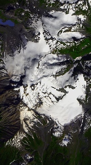
The Garibaldi Névé is a snowfield in the Pacific Ranges of the Coast Mountains in southwestern British Columbia, Canada, located on the north and east sides of Mount Garibaldi in New Westminster Land District. The névé along with its outlet glaciers have a combined area of about 30 square kilometres.

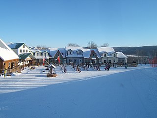
Ninette is an unincorporated community recognized as a local urban district located in Manitoba, Canada at the north end of Pelican Lake. It is located in the Rural Municipality of Prairie Lakes. Ninette has many small businesses, and is known locally for its wide range of sports facilities. In the summer, activities such as boating, fishing, and hunting are offered, while snowmobiling and ice fishing are offered during the wintertime.

Amisk Lake is a lake in the east-central part of the Canadian province of Saskatchewan, about 22 kilometres (14 mi) south-west of Flin Flon, Manitoba. 'Amisk' means beaver in Cree. Along the lake's shores is the community of Denare Beach, a provincial recreation site with lake access and camping, and prehistoric limestone crevices. Access to the lake and its amenities is from Highway 167. Amisk Lake was on an important fur trade route in the 18th century.
The Rural Municipality of Sasman No. 336 is a rural municipality (RM) in the Canadian province of Saskatchewan within Census Division No. 10 and SARM Division No. 4.
Shoal Lake is a locality in the southwest of Manitoba, Canada. Originally incorporated as a town, Shoal Lake amalgamated with the Rural Municipality of Shoal Lake on January 1, 2011 to form the Municipality of Shoal Lake, which became the Rural Municipality of Yellowhead on January 1, 2015.

Good Spirit Lake Provincial Park is a provincial park on the eastern side of the Canadian province of Saskatchewan. Founded in 1931, the park surrounds the western and southern shores of Good Spirit Lake and is one of Saskatchewan's six founding provincial parks. The park is in the RM of Good Lake No. 274, about 48 kilometres (30 mi) north of the city of Yorkton. Highway 47 runs along the western boundary and Highway 229 provides access to the park's amenities.
Bernice Wildlife Management Area is a wildlife management area located northeast of Melita, Manitoba, Canada. It is 65 hectares (0.25 sq mi) in size.
Culdesac Lake is a lake in the Canadian provinces of Saskatchewan and Manitoba. It is situated in the Saskatchewan River Delta and is in the Mid-Boreal Lowland ecoregion. It is surrounded by muskeg and boreal forest. Its primary inflow is from a channel connected to Culdesac River, which is a tributary of Carrot River. An outlet from the eastern end of Culdesac Lake connects it to the Pasquia River — a tributary of the Saskatchewan River. The lake falls within the Cumberland Marshes Important Bird Area of Canada.

