
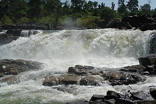
Amarkantak is a pilgrim town and a Nagar Panchayat in Anuppur, Madhya Pradesh, India. The Amarkantak region is a unique natural heritage area and is the meeting point of the Vindhya and the Satpura Ranges, with the Maikal Hills being the fulcrum. This is where the Narmada River, the Son River and Johilla River originate.

Shahdol District is a district of Madhya Pradesh state in east central India. It old name was Matsya raj or Virat kingdom in the name of great king Maharaja Virata. With a total area of 6,205 km2 (2,396 sq mi) and a population of 10,66,063. Shahdol is an important district of Madhya Pradesh. The town of Shahdol is the district headquarters. The district formerly comprised Shahdol division.

Sidhi District is one of the tribal districts of Madhya Pradesh state of India. The town of Sidhi is the district headquarters. The district is part of Rewa Division.
Umaria district is a district of Madhya Pradesh. The town of Umaria is the district headquarters. The district is part of Shahdol Division.

Guna district is one of the 52 districts of Madhya Pradesh in central India. Its administrative headquarters is Guna. The district has a population of 1,241,519. It has an area of 6390 km², and is bounded on the northeast by Shivpuri District, on the east by Ashoknagar District, on the southeast by Vidisha District, on the southwest by Rajgarh District, on the west and northwest by Jhalawar and Baran districts of Rajasthan state. The Sindh River flows northward along the eastern edge of the district, forming part of the boundary with Ashoknagar District, and the Parvati River flows northwestward through the southern portion of the district, forming part of the boundary with Baran District before flowing into Rajasthan.

Anuppur District (अनूपपुर) is an administrative district in Shahdol Division of Madhya Pradesh state in central India.

Ujjain district is a district of Madhya Pradesh state in central India. The historic city of Ujjain is the district headquarters. The district has an area of 6,091 km2, and a population of 19,86,864, a 16.12% increase from its 2001 population of 17,10,982.

The Indore District is a district of Madhya Pradesh state in central India. It is believed that the city is named after its Indreshwar Mahadev Temple, Where Indra is the presiding deity. The Gupta inscriptions name Indore as "Indrapura". It is also called the administrative capital. This district forms part of the Indore Division.

Lalitpur is one of the 75 districts in the northern Indian state of Uttar Pradesh. Lalitpur district is a part of Jhansi Division. Lalitpur is the main town and administrative headquarters. The district occupies an area of 5,039 km2.
Shahdol is a City in Shahdol district in the Indian state of Madhya Pradesh. It is the administrative headquarters of Shahdol district, The total geographical area of the district is 5,671 square kilometres (2,190 sq mi).
Bijuri is a town and a Municipality or Municipal Council or Nagar Palika Parishad in Anuppur district in the state of Madhya Pradesh, India.
Devhara is a census town in anuppur district in the state of Madhya Pradesh, India. Devhara is also the biggest gram panchayat in Anuppur district.
Jaithari is a town and a tehsil in Anuppur district in the Indian state of Madhya Pradesh.
Nowrozabad or Khodargama is a city and a Nagar Palika in Umaria district in the Indian state of Madhya Pradesh. Kendriya Vidyalaya Nowrozabad is situated in the G.M Complex Johilla area. Nowrozabad is the head office of Johilla area. The nearest Airport is at Jabalpur in Madhya pradesh. Nowrozabad Railway Station is on the Katni - Anuppur rail route. There are many coal mines around here. National Highway 43 has its route through Nowrozabad.
Shahdol is one of the 29 Lok Sabha constituencies in Madhya Pradesh state in central India. This constituency is reserved for the candidates belonging to the Scheduled tribes. It covers the entire Anuppur and Umaria districts and parts of Shahdol and Katni districts.
Bilaspur is a village in Umaria district, Madhya Pradesh, India. Bilaspur is covered under Anuppur Assembly constituency at state level and Shahdol parliamentary constituency at national level. Bilaspur village is a gram panchayat as per the 2011 Census of India. The village has 250 houses with a population of 1,118 members consisting of 561 males and 557 females. Male literacy is 57.4% and female literacy is 40.04% making an average of 48.75%. Bilaspur is headed by a sarpanch who is elected through local elections.
Beohari is a major town and a nagar panchayat in Shahdol district in the state of Madhya Pradesh, India. It is 79.07 kilometres (49.13 mi) from the main district of Shahdol and 412 kilometres (256 mi) away from Bhopal, the state capital. Its geographical coordinates are 24° 3' 0" North, 81° 23' 0" East.
Gyan Singh is an Indian politician from the state of Madhya Pradesh. He was first elected to Lok Sabha in 1996 General Election.

Anuppur is one of the 230 Vidhan Sabha constituencies of Madhya Pradesh state in central India. It is a segment of Shahdol. As of 2023, its representative is Bisahulal Singh of the Bharatiya Janata Party.

Pushprajgarh is one of the 230 Vidhan Sabha constituencies of Madhya Pradesh state in central India. It is a segment of Shahdol.


