Arabian-Persian Gulf Coastal Plain Desert | |
---|---|
Ecology | |
Realm | Palearctic |
Biome | Deserts and xeric shrublands |
Geography | |
Area | 72,801 km2 (28,109 sq mi) |
Country | Saudi Arabia, Kuwait, Bahrain, Qatar, United Arab Emirates, Iraq |
Coordinates | 26°45′N49°15′E / 26.75°N 49.25°E |
The Arabian-Persian Gulf Coastal Plain Desert ecoregion (WWF ID: PA1323) covers the desert coastal plain of the northwest Persian Gulf, that is, on the northeast Arabian Peninsula, from Kuwait in the north to a small coastal sector in the United Arab Emirates to the southeast. [1] [2] [3] [4] [5]
Bounded on the east by the Persian Gulf, the ecoregion is effectively surrounded on its other sides by the Arabian desert and East Sahero-Arabian xeric shrublands ecoregion. The inland reaches of the ecoregion are a flat extension of the coastal plain, ending at the red-brown dunes of the ad-Dahna Desert and in the south at the edge of the "Empty Quarter" of Saudi Arabia, the Rub' al Khali. [4] The maximum elevation in the ecoregion is 313 metres (1,027 ft). [3]
The geology of the plains are marine sediments laid down in the Tertiary (66 to 3 million years ago), when the region was intermittently submerged. Because of limestone, the sands of the ecoregion are whiter than those of the other deserts of the Arabian Peninsula, which are mostly igneous and metamorphic. [4] Along the coast there are salt-flat depressions known as sabkhas.
The climate of the ecoregion is Hot desert climate (Köppen climate classification (BWk)). This climate features stable air and high pressure aloft, producing a hot, arid desert. Hot-month temperatures typically average 29–35 °C (84–95 °F). [6] [7] Peak temperatures of 50 50 °C (122 °F) have been recorded. Northerly winds often bring sandstorms. Humidity near the coast can reach 90% in the summer. Annual precipitation averages 75–150 mm/year, occurring in winter. [4]
95% of the territory is bare ground or sparse vegetation. The vegetation is small shrubs, grass tussocks, and occasional larger shrubs of Tamarisk. [4] Vegetation near the coast is characterized by Haloxylotea salicornici and Suaedetea deserti . Further inland the vegetation is characterized by Hammadetea salicornici . [4] The most widespread shrubs are Rhanterium epapposum , Haloxylon salicornicum , and Calligonum comosum . Common grasses are Panicum turgidum and Mediterranean needle-grass Stipa capensis ; common sedges are Cyperus conglomeratus . [4]
On the coast, the inter-tidal mudflats and islands are important breeding and resting habitat for migratory birds. The vulnerable Socotra cormorant ( Phalacrocorax nigrogularis ) is resident in significant colonies, particularly in a protected area of the Hawar Islands of Bahrain. [4] Inland, small patches of irrigated land above aquifers create wetland habitats that support migrating birds and species that include Marsh frogs ( Rana ridibunda ) and Caspian pond turtles ( Clemmys caspica ). Characteristic mammals of the ecoregion are the Red fox ( Vulpes vulpes ), Cape hare ( Lepus capensis ), and Ethiopian hedgehog ( Paraechinus aethiopicus ). [4]
Almost 4% of the ecoregion is officially protected. [3] These protected areas include:
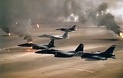
In January 1991 during the Gulf War, Iraqi forces released about 1.7 million m³ (11 million barrels) of oil from storage tanks and tankers directly into the Persian Gulf. In February, they also destroyed 1,164 Kuwaiti oil wells. It took nine months to extinguish these oil fires. These oil spills contaminated 1,000 km (620 mi) of Persian Gulf coast. The result of the pollution was the death of thousands of water birds and serious damage to the Persian Gulf's aquatic ecosystem, particularly shrimp, sea turtles, dugongs, whales, dolphins and fish. The damaged wells also released 10 million m3 (60 million barrels) of oil into the desert and formed lakes (total surface of 49 square kilometers). All this damage was done to impede Coalition forces.
Just before the 2003 Iraq War, they also set fire to various oil fields. [8] [9] [10]
The Kingdom of Saudi Arabia is a country situated in West Asia, the largest country on the Arabian Peninsula, bordering the Persian Gulf and the Red Sea. Its extensive coastlines provide great leverage on shipping through the Persian Gulf and the Suez Canal. The kingdom occupies 80% of the Arabian Peninsula. Most of the country's boundaries with the United Arab Emirates (UAE), Oman, and the Republic of Yemen are undefined, so the exact size of the country remains unknown. The Saudi government estimate is at 2,217,949 square kilometres, while other reputable estimates vary between 2,149,690 and 2,240,000 sq. kilometres. Less than 7% of the total area is suitable for cultivation, and in the early 1960s, population distribution varied greatly among the towns of the eastern and western coastal areas, the densely populated interior oases, and the vast, almost empty deserts.
The Arabian Desert is a vast desert wilderness in West Asia that occupies almost the entire Arabian Peninsula with an area of 2,330,000 square kilometers (900,000 sq mi). It stretches from Yemen to the Persian Gulf and Oman to Jordan and Iraq. It is the fifth largest desert in the world and the largest in Asia. At its center is Ar-Rub' al-Khali, one of the largest continuous bodies of sand in the world. It is an extension of the Sahara Desert.
The ecology of California can be understood by dividing the state into a number of ecoregions, which contain distinct ecological communities of plants and animals in a contiguous region. The ecoregions of California can be grouped into four major groups: desert ecoregions, Mediterranean ecoregions, forested mountains, and coastal forests.
The Serengeti volcanic grasslands is a tropical grassland ecoregion of Tanzania. The Serengeti volcanic grasslands are distinctive grasslands growing on deposits of volcanic ash in northern Tanzania. It includes the eastern portion of Serengeti National Park and areas south and east of the Ngorongoro Highlands.
British Columbia mainland coastal forests is a temperate coniferous forest ecoregion the Pacific coast of North America, as defined by the World Wildlife Fund (WWF) categorization system.
The Gulf of Oman desert and semi-desert is a coastal ecoregion on the Persian Gulf and the Gulf of Oman in Oman and the United Arab Emirates at the northeastern tip of the Arabian Peninsula. The climate is hot and dry, with gravelly plains and savanna with thorny acacia trees inland from the coast. Along the coast there are mixture of habitats that include mangrove swamps, lagoons and mudflats. The mangrove areas are dominated by Avicennia marina and the savanna by Prosopis cineraria and Vachellia tortilis. Masirah Island is an important breeding area for the loggerhead sea turtle and other sea turtles also occur here, as well as a great variety of birds, some resident and some migratory. There are some protected areas, but in general the habitats have been degraded by the grazing of livestock, especially camels and goats; they are also at risk from oil spills, off-road driving and poaching.
Biogeographic classification of India is the division of India according to biogeographic characteristics. Biogeography is the study of the distribution of species (biology), organisms, and ecosystems in geographic space and through geological time. India has a rich heritage of natural diversity. India ranks fourth in Asia and tenth in the world amongst the top 17 mega-diverse countries in the world. India harbours nearly 11% of the world's floral diversity comprising over 17500 documented flowering plants, 6200 endemic species, 7500 medicinal plants and 246 globally threatened species in only 2.4% of world's land area. India is also home to four biodiversity hotspots—Andaman & Nicobar Islands, Eastern Himalaya, Indo-Burma region, and the Western Ghats. Hence the importance of biogeographical study of India's natural heritage.
The Belizean pine forests is an ecoregion that represents an example of lowland and premontane pine forests in the Neotropical realm, where the dominant tree species is Caribbean pine. The vegetation here is generally adapted to the xeric, acidic and nutrient-poor conditions along the Belizean near coastal zone of the Caribbean versant.
The Taimyr-Central Siberian tundra ecoregion is an ecoregion that broadly covers the Taymyr Peninsula in the Russian Far North. It ranges from the delta of the Yenisei River in the west, across the Taymyr Peninsula and Khatanga Gulf, to the Lena River delta in the east. The region is an important area for breeding birds. It is in the Palearctic realm in the tundra biome, and is mostly located in Taymyrsky Dolgano-Nenetsky District of Krasnoyarsk Krai. It has an area of 954,670 square kilometres (368,600 sq mi).
The Caspian lowland desert ecoregion covers the north and southeast coasts of the Caspian Sea, including the deltas of the Volga River and Ural River in the northern region. While the region gets relatively low amounts of precipitation, wildlife is supported by the river estuaries and the sea itself. The wetlands are an internationally important area for bird nesting and migratory resting. The ecoregion is in the Palearctic realm, and the deserts and xeric shrublands biome. It has an area of 267,300 square kilometres (103,200 sq mi).
The wildlife of Kuwait consists of the flora and fauna of Kuwait and their natural habitats. Kuwait is a country in the Middle East at the head of the Persian Gulf, located between Iraq and Saudi Arabia.
The Southwestern Arabian foothills savanna, also known as the Southwestern Arabian Escarpment shrublands and woodlands, is a desert and xeric shrubland ecoregion of the southern Arabian Peninsula, covering portions of Saudi Arabia, Yemen, and Oman.
The Altai steppe and semi-desert ecoregion, as its name indicates, sits in a transition zine between steppe and semi-desert, supporting sparse grass and shrublands. The area is relatively undeveloped, with agriculture mostly represented by grazing livestock. There are a few shallow lakes in depressions used by migratory birds.
The Middle East steppe ecoregion stretches in an arc from southern Jordan across Syria and Iraq to the western border of Iran. The upper plains of the Tigris and Euphrates Rivers dominate most of the ecoregion. The terrain is mostly open shrub steppe. The climate is arid. Evidence is that this region was once more of a forest-steppe, but centuries of overgrazing and gathering firewood have reduced tree and grass cover to small areas and along the riverine corridors. Despite the degraded condition of the steppe environment, the ecoregion is important for water birds as the rivers and reservoirs provide habitat in the arid region.
The Afghan Mountains semi-desert ecoregion covers three disconnected interior valleys in the north of the mountains of Afghanistan. These valleys are arid, and covered mostly in thorny shrubs. Overgrazing by livestock has put pressure on the grasses and the wild animals dependent on them.
The South Iran Nubo–Sindian desert and semi-desert ecoregion covers the northern coastal plain of the Persian Gulf and the inland desert hills south of the Zagros Mountains of Iran. The region also has extensions reaching into southeastern Iraq, and eastward into southwestern Pakistan. The region is one of hot sand deserts, shrubland, and open thorn woodlands inland. Mangrove forests and swamps are found along the coast.
The Red Sea Nubo–Sindian tropical desert and semi-desert ecoregion covers extremely arid land along the northeastern Red Sea, the southern Sinai Peninsula, and on a thin strip along the Israel-Jordan border. Most of the coastal land is flat, but there are high mountains in southern Sinai. Biodiversity is limited by the low moisture levels – some areas go for years without significant rain. Portions of the area support a thin savannah-like cover of widely scattered trees and scrub, surrounded by grasses that briefly flourish after a rainfall. Biodiversity is highest in the mountains of Sinai, and in the wadis and gullies that retain moisture.
The Paropamisus xeric woodlands ecoregion covers the portion of northeastern Afghanistan north of the central mountain range and the Hindu Kush Mountains. The name is derived from the Old Persian name for the region, Parupraesanna. While there are low canopy woodlands in the northeast of the ecorgegion, most of the territory is desert or xeric (dry) scrubland.
The Mesopotamian shrub desert is a deserts and xeric shrublands ecoregion in Western Asia. It extends across portions of Israel, Jordan, Syria, Iraq, and Iran.
The Baluchistan xeric woodlands ecoregion covers the middle elevations of a series of mountain ranges of western Pakistan and northeastern Afghanistan, reaching 1,200 kilometres (750 mi) from the Arabian Sea in the south to the Hindu Kush Mountains and the Himalayas in the north. The characteristic vegetation is xeric (dry) woodlands of shrubs and herbaceous cover. The region has rich biodiversity but relatively few endemic species.