The Northern Territory is an Australian internal territory in the central and central-northern regions of Australia. The Northern Territory shares its borders with Western Australia to the west, South Australia to the south, and Queensland to the east. To the north, the Northern Territory looks out to the Timor Sea, the Arafura Sea and the Gulf of Carpentaria, including Western New Guinea and various other islands of the Indonesian archipelago.

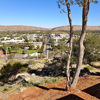
Alice Springs is a town in the Northern Territory, Australia; it is the third-largest settlement after Darwin and Palmerston. The name Alice Springs was given by surveyor William Whitfield Mills after Alice, Lady Todd, wife of the telegraph pioneer Sir Charles Todd. Known colloquially as The Alice or simply Alice, the town is situated roughly in Australia's geographic centre. It is nearly equidistant from Adelaide and Darwin.

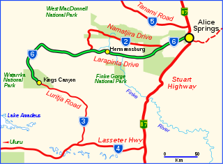
Hermannsburg, also known as Ntaria, is an Aboriginal community in Ljirapinta Ward of the MacDonnell Shire in the Northern Territory of Australia, 125 kilometres (78 mi); west southwest of Alice Springs, on the Finke River, in the traditional lands of the Western Arrarnta people.
Wenten Rubuntja was an Aboriginal Australian artist. His early watercolour paintings are typical of the Hermannsburg School of art, while his later work includes dot painting. He was also an Aboriginal rights activist who worked on the Central Land Council in the Northern Territory for several years.

The Araluen Cultural Precinct, formerly the Araluen Centre for Arts & Entertainment, in Alice Springs (Mparntwe) in the Northern Territory of Australia, is a cultural precinct which includes the Araluen Arts Centre, the Museum of Central Australia, Central Australian Aviation Museum, Kookaburra Memorial, the Yeperenye Sculpture, Central Craft, Yaye's Cafe and Aboriginal sacred sites.
Kintore is a remote settlement in the Kintore Range of the Northern Territory of Australia about 530 km (330 mi) west of Alice Springs and 40 km (25 mi) from the border with Western Australia. It is also known as Walungurru, Walangkura, and Walangura.
The Strehlow Research Centre is a museum and cultural centre within the Museum of Central Australia, which is situated in the Araluen Cultural Precinct in the town of Alice Springs in the Northern Territory of Australia.

Larapinta Drive is a designated state route in the Northern Territory of Australia.

Arltunga Historical Reserve, known also as Arnerre-ntyenge is a deserted gold rush town located in the Northern Territory of Australia in the locality of Hart about 110 kilometres (68 mi) east of Alice Springs. It is on the lands of the Eastern Arrernte people who are the traditional owners.
Braitling is a suburb of the town of Alice Springs in the Northern Territory, Australia. It is on the traditional Country of the Arrernte people.
Ciccone is an industrial suburb of Alice Springs with a population of around 255 (2016). It is on the traditional Country of the Arrernte people.
Gillen is a suburb of the town of Alice Springs in the Northern Territory, Australia. It is on the traditional Country of the Arrernte people.
Larapinta is an outer suburb of the town of Alice Springs, in the Northern Territory, Australia. It is on the western side of Alice Springs, on the traditional Country of the Arrernte people.
Connellan is an outer suburb of the town of Alice Springs, in the Northern Territory of Australia.
Flynn is an outer suburb of the town of Alice Springs, in the Northern Territory, Australia. It is on the traditional Country of the Arrernte people.
Ross is an outer suburb of the town of Alice Springs, in the Northern Territory, Australia. It is on the traditional Country of the Arrernte people.
Arumbera is an outer suburb of the town of Alice Springs, in the Northern Territory, Australia. It is on the traditional Country of the Arrernte people.
Sadadeen is a suburb of the town of Alice Springs, in the Northern Territory, Australia. It is on the traditional Country of the Arrernte people.
Desert Springs is a suburb of the town of Alice Springs, in the Northern Territory, Australia. It is on the traditional country of the Arrernte people.
Kilgariff is a suburb of Alice Springs located in the Northern Territory of Australia about 1,290 kilometres (800 mi) south of the territory capital of Darwin and about 7 kilometres (4.3 mi) south of the municipal seat in the Alice Springs central business district. Kilgariff is located within the federal division of Lingiari, the territory electoral division of Braitling and the local government area of the Town of Alice Springs. It is on the traditional Country of the Arrernte people.


