
The Northern Territory is an Australian territory in the central and central northern regions of Australia. The Northern Territory shares its borders with Western Australia to the west, South Australia to the south, and Queensland to the east. To the north, the territory looks out to the Timor Sea, the Arafura Sea and the Gulf of Carpentaria, including Western New Guinea and other islands of the Indonesian archipelago.
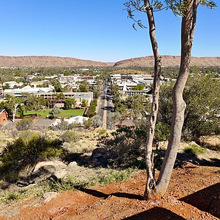
Alice Springs is a town in the Northern Territory, Australia; the third largest settlement after Darwin and Palmerston. The name Alice Springs was given by surveyor William Whitfield Mills after Alice, Lady Todd, wife of the telegraph pioneer Sir Charles Todd. Known colloquially as "The Alice" or simply "Alice", the town is situated roughly in Australia's geographic centre. It is nearly equidistant from Adelaide and Darwin.

Stuart Highway is a major Australian highway. It runs from Darwin, in the Northern Territory, via Tennant Creek and Alice Springs, to Port Augusta in South Australia; a distance of 2,720 km (1,690 mi). Its northern and southern extremities are segments of Australia's Highway 1. The principal north–south route through the central interior of mainland Australia, the highway is often referred to simply as "The Track".
Pimba is a small settlement lying on the transcontinental railway line in the Australian state of South Australia. It lies at the junction of the Stuart Highway to Alice Springs and the road to Woomera, Roxby Downs and Andamooka. It is 441 kilometres (274 mi) from Adelaide. There is an iconic roadhouse, named "Spud's Roadhouse", which sells fuel and general shop items and meals and has accommodation.

The Alice Springs Town Council is a local government area in the Northern Territory. On 1 July 1971, Alice Springs was gazetted as a Municipality with the town council elected on 25 July 1971. It is situated 1,498 kilometres (931 mi) south of Darwin. The council governs an area of 328 square kilometres (127 sq mi) and had a population of 26,534 in June 2018.
Elliott is a town in Northern Territory of Australia. It is almost halfway between Darwin and Alice Springs on the Stuart Highway. The town is in the Yapurkulangu ward of the Barkly Region. At the 2016 census, Elliott had a population of 339.
Ciccone is an industrial suburb of Alice Springs with a population of around 255 (2016). Ciccone is located right next to Stuart Highway. There are a small number of houses on the north-western side of Ciccone, but the area is mostly industrial.
Gillen is a suburb of the town of Alice Springs in the Northern Territory, Australia.
Larapinta is a suburb of the town of Alice Springs, in the Northern Territory, Australia. It is on the western side of Alice Springs.
Ilparpa is a suburb of the town of Alice Springs, in the Northern Territory, Australia.
Connellan is a suburb of the town of Alice Springs, in the Northern Territory of Australia.
Ross is a suburb of the town of Alice Springs, in the Northern Territory, Australia.
Undoolya is a suburb of the town of Alice Springs, in the Northern Territory, Australia.

The Gap is a suburb of the town of Alice Springs, in the Northern Territory, Australia. It is located at the Heavitree Gap.
Sadadeen is a suburb of the town of Alice Springs, in the Northern Territory, Australia.
Desert Springs is a suburb of the town of Alice Springs, in the Northern Territory, Australia.
Mereenie is a locality in the Northern Territory of Australia. It is about 250 km west of Alice Springs and northeast of Uluru. It is on the "Inner Mereenie Loop" road which was completed as a sealed road in 2016 providing access for caravans and two-wheel-drive vehicles.
Kilgariff is a suburb of Alice Springs located in the Northern Territory of Australia about 1,290 kilometres (800 mi) south of the territory capital of Darwin and about 7 kilometres (4.3 mi) south of the municipal seat in the Alice Springs central business district. Kilgariff is located within the federal division of Lingiari, the territory electoral division of Braitling and the local government area of the Town of Alice Springs.
Mount Zeil is a locality in the Northern Territory of Australia located about 1,248 kilometres (775 mi) south of the territory capital of Darwin.
Hugh is a locality in the Northern Territory, Australia, located about 1,328 kilometres (825 mi) south of the territory capital of Darwin.

