
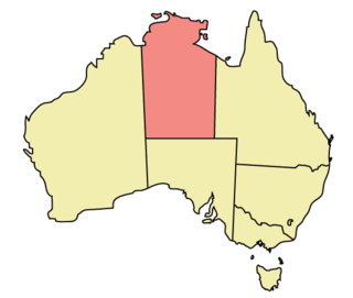
The Northern Territory is an Australian territory in the central and central northern regions of Australia. The Northern Territory shares its borders with Western Australia to the west, South Australia to the south, and Queensland to the east. To the north, the territory looks out to the Timor Sea, the Arafura Sea and the Gulf of Carpentaria, including Western New Guinea and other islands of the Indonesian archipelago.
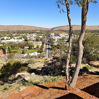
Alice Springs is a town in the Northern Territory, Australia; the third largest settlement after Darwin and Palmerston. The name Alice Springs was given by surveyor William Whitfield Mills after Alice, Lady Todd, wife of the telegraph pioneer Sir Charles Todd. Known colloquially as "The Alice" or simply "Alice", the town is situated roughly in Australia's geographic centre. It is nearly equidistant from Adelaide and Darwin.
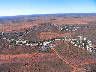
Yulara is a town in the southern region of the Northern Territory, Australia. It lies as an unincorporated enclave within MacDonnell Region. At the 2016 census, Yulara had a permanent population of 1,099, in an area of 103.33 square kilometres (39.90 sq mi). It is 18 kilometres (11 mi) by road from World Heritage Site Uluru and 55 kilometres (34 mi) from Kata Tjuta. It is located in the Northern Territory electorate of Gwoja and the federal electorate of Lingiari.
Kintore is a remote settlement in the Kintore Range of the Northern Territory of Australia about 530 km (330 mi) west of Alice Springs and 40 km (25 mi) from the border with Western Australia. It is also known as Walungurru, Walangkura, and Walangura.
Crime in the Northern Territory is managed by the Northern Territory Police, the territory government's Department of the Attorney-General and Justice and Territory Families.
Arrernte or Aranda or sometimes referred to as Upper Arrernte, is a dialect cluster in the Arandic language group spoken in parts of the Northern Territory, Australia, by the Arrernte people. Other spelling variations are Arunta or Arrarnta, and all of the dialects have multiple other names.
Ltyentye Apurte, also known as Santa Teresa, is a community in the Northern Territory, Australia, many residents of the locality are members of the Arrernte indigenous community, whose origins are located about 80 kilometres (50 mi) south-east of Alice Springs.
Araluen is a suburb of the town of Alice Springs, in the Northern Territory, Australia. It is on the western side of Alice Springs.
Gillen is a suburb of the town of Alice Springs in the Northern Territory, Australia.
Larapinta is a suburb of the town of Alice Springs, in the Northern Territory, Australia. It is on the western side of Alice Springs.
Flynn is a suburb of the town of Alice Springs, in the Northern Territory, Australia.
Ross is a suburb of the town of Alice Springs, in the Northern Territory, Australia.
Arumbera is a suburb of the town of Alice Springs, in the Northern Territory, Australia.
Mount Johns is a suburb of the town of Alice Springs, in the Northern Territory, Australia.
Kilgariff is a suburb of Alice Springs located in the Northern Territory of Australia about 1,290 kilometres (800 mi) south of the territory capital of Darwin and about 7 kilometres (4.3 mi) south of the municipal seat in the Alice Springs central business district. Kilgariff is located within the federal division of Lingiari, the territory electoral division of Braitling and the local government area of the Town of Alice Springs.
Lake Mackay is a locality in the Northern Territory of Australia located on the territory’s south-west adjoining the border with the state of Western Australia about 1,202 kilometres (747 mi) south of the territory capital of Darwin and about 458 kilometres (285 mi) west of the municipal seat in Alice Springs.
Burt Plain is a locality in the Northern Territory of Australia located about 1,249 kilometres (776 mi) south of the territory capital of Darwin.
Hugh is a locality in the Northern Territory, Australia, located about 1,328 kilometres (825 mi) south of the territory capital of Darwin.
Mount Liebig is an Aboriginal community in the Northern Territory of Australia located about 325 kilometres (202 mi) west of Alice Springs.
Kunparrka is a locality in the Northern Territory, Australia, located about 1,210 kilometres (750 mi) south of the territory capital of Darwin.

