
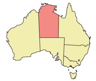
The Northern Territory is an Australian territory in the central and central northern regions of Australia. The Northern Territory shares its borders with Western Australia to the west, South Australia to the south, and Queensland to the east. To the north, the territory looks out to the Timor Sea, the Arafura Sea and the Gulf of Carpentaria, including Western New Guinea and other islands of the Indonesian archipelago.
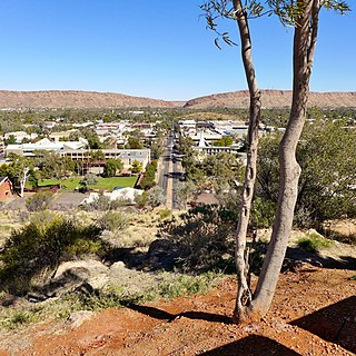
Alice Springs is a town in the Northern Territory, Australia; the third largest settlement after Darwin and Palmerston. The name Alice Springs was given by surveyor William Whitfield Mills after Alice, Lady Todd, wife of the telegraph pioneer Sir Charles Todd. Known colloquially as "The Alice" or simply "Alice", the town is situated roughly in Australia's geographic centre. It is nearly equidistant from Adelaide and Darwin.

Farina, formerly Farina Town and originally Government Gums, is an abandoned town in the Australian state of South Australia. The name also applies to an area of about 8500 square kilometres in which the town is located. At the 2006 census, 55 people lived in the larger area; by the 2021 census, the population had fallen to 15.
Crime in the Northern Territory is managed by the Northern Territory Police, the territory government's Department of the Attorney-General and Justice and Territory Families.
Wandering is a town located in the Wheatbelt region of Western Australia, approximately 120 kilometres (75 mi) from the state capital, Perth, just off the Albany Highway. It is the main town in the Shire of Wandering. At the 2016 census, Wandering had a population of 294.

The Alice Springs Town Council is a local government area in the Northern Territory. On 1 July 1971, Alice Springs was gazetted as a Municipality with the town council elected on 25 July 1971. It is situated 1,498 kilometres (931 mi) south of Darwin. The council governs an area of 328 square kilometres (127 sq mi) and had a population of 26,534 in June 2018.
Araluen is a suburb of the town of Alice Springs, in the Northern Territory, Australia. It is on the western side of Alice Springs.
Gillen is a suburb of the town of Alice Springs in the Northern Territory, Australia.
Larapinta is a suburb of the town of Alice Springs, in the Northern Territory, Australia. It is on the western side of Alice Springs.
Irlpme is a suburb of the town of Alice Springs, in the Northern Territory, Australia.
Ilparpa is a suburb of the town of Alice Springs, in the Northern Territory, Australia.
Connellan is a suburb of the town of Alice Springs, in the Northern Territory of Australia.
Flynn is a suburb of the town of Alice Springs, in the Northern Territory, Australia.
East Side is a suburb of the town of Alice Springs, in the Northern Territory, Australia.
Stuart is a suburb of the town of Alice Springs, in the Northern Territory, Australia.
Ross is a suburb of the town of Alice Springs, in the Northern Territory, Australia.
Undoolya is a suburb of the town of Alice Springs, in the Northern Territory, Australia.

The Gap is a suburb of the town of Alice Springs, in the Northern Territory, Australia. It is located at the Heavitree Gap.
Sadadeen is a suburb of the town of Alice Springs, in the Northern Territory, Australia.
Desert Springs is a suburb of the town of Alice Springs, in the Northern Territory, Australia.

