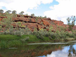
The Finke River, or Larapinta in the Indigenous Arrernte language, is a river in central Australia, whose bed courses through the Northern Territory and the state of South Australia. It is one of four main rivers of the Lake Eyre Basin and thought to be the oldest riverbed in the world. It flows for only a few days a year. When this happens, its water usually disappears into the sands of the Simpson Desert, rarely if ever reaching Lake Eyre.
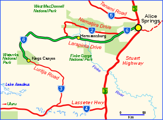
Larapinta Drive is a designated state route in the Northern Territory of Australia.
Araluen is a suburb of the town of Alice Springs, in the Northern Territory, Australia. It is on the western side of Alice Springs.
Braitling is a suburb of the town of Alice Springs in the Northern Territory, Australia.
Ciccone is an industrial suburb of Alice Springs with a population of around 255 (2016). Ciccone is located right next to Stuart Highway. There are a small number of houses on the north-western side of Ciccone, but the area is mostly industrial.
Gillen is a suburb of the town of Alice Springs in the Northern Territory, Australia.
Ilparpa is a suburb of the town of Alice Springs, in the Northern Territory, Australia.
Connellan is a suburb of the town of Alice Springs, in the Northern Territory of Australia.
Flynn is a suburb of the town of Alice Springs, in the Northern Territory, Australia.
Ross is a suburb of the town of Alice Springs, in the Northern Territory, Australia.
Arumbera is a suburb of the town of Alice Springs, in the Northern Territory, Australia.
Undoolya is a suburb of the town of Alice Springs, in the Northern Territory, Australia.
Mount Johns is a suburb of the town of Alice Springs, in the Northern Territory, Australia.
Sadadeen is a suburb of the town of Alice Springs, in the Northern Territory, Australia.
Desert Springs is a suburb of the town of Alice Springs, in the Northern Territory, Australia.
Larapinta is the Arrernte name for the Finke River in Australia
Mereenie is a locality in the Northern Territory of Australia. It is about 250 km west of Alice Springs and northeast of Uluru. It is on the "Inner Mereenie Loop" road which was completed as a sealed road in 2016 providing access for caravans and two-wheel-drive vehicles.
Kilgariff is a suburb of Alice Springs located in the Northern Territory of Australia about 1,290 kilometres (800 mi) south of the territory capital of Darwin and about 7 kilometres (4.3 mi) south of the municipal seat in the Alice Springs central business district. Kilgariff is located within the federal division of Lingiari, the territory electoral division of Braitling and the local government area of the Town of Alice Springs.

John Flynn's Grave Historical Reserve, more commonly referred to as Flynn's Grave is the grave site of John Flynn who was an Australian Presbyterian minister who founded the Australian Inland Mission (AIM) and founding the Royal Flying Doctor Service. The grave, which is now a historical reserve, is located at the base of Mount Gillen on Larapinta Drive in the Alice Springs suburb of Flynn.
Hugh is a locality in the Northern Territory, Australia, located about 1,328 kilometres (825 mi) south of the territory capital of Darwin.

