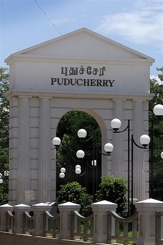
The Puducherry district, also known by its former name Pondicherry district, is one of the four districts of the union territory of Puducherry in South India. The district occupies an area of 290 square kilometres (110 sq mi), spread over 11 non-contiguous enclaves lying on or near the Bay of Bengal within a compact area in the state of Tamil Nadu. According to the 2011 census, the district has a population of 950,289.
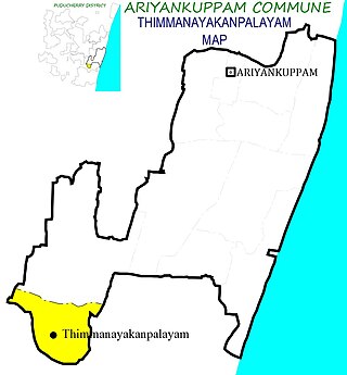
Thimmanayakanpalayam also known as T.N. Palayam is a panchayat village in Ariyankuppam Commune in the Union Territory of Puducherry. It is also a revenue village under Ariyankuppam Firka
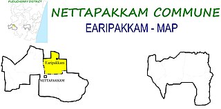
Earipakkam is a panchayat village in Nettapakkam Commune in the Union Territory of Puducherry, India. It is also a revenue village under Nettapakkam firka.
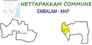
Embalam is a panchayat village in Nettapakkam Commune in the Union Territory of Puducherry, India.

Karikalampakkam is a panchayat village in Nettapakkam Commune in the Union Territory of Puducherry, India. It is also a revenue village under Nettapakkam firka. If splitting the Name of Karikalampakkam and translating into English it will give the reason of village name by how it came. Kari - Dark; akalam - Non Leaving; pakkam - the place or location. So when the Pondicherry under French rule, this place identified by the other village people by noticing the full darkness; occupying entire area of the village even at day time, because this village covered fully by big trees and it won't allow the light passing inside.
Karaiyamputhur is a village in Bahour Commune of Bahour taluk in the Union Territory of Puducherry, India. It is one of the 11 Enclaves of Puducherry. Karaiyamputhur serves as a gateway to Puducherry - Panruti route. It lies on the southwesternmost tip of Puducherry district.
Panayadikuppam otherwise known as Panaiyadikuppam or Panaiyadikkuppamis is a village in Bahour Commune of Bahour taluk in the Union Territory of Puducherry, India. It lies on the north part of Karaiyamputhur Enclave of Puducherry. Panayadikuppam serves as a gateway to Nettapakkam from Bahour. Panayadikuppam is a part of Karaiyamputhur Village Panchayat.
Manamedu is a village in Bahour Commune of Bahour taluk in the Union Territory of Puducherry, India. It is one of the 11 Enclaves of Puducherry. Manmedu serves as a gateway to Pondicherry - Nellikuppam route. It lies on the banks of Pennaiyar River
Kaduvanoor is a village in Bahour Commune of Bahour taluk in the Union Territory of Puducherry, India. It is one of the 11 Enclaves of Puducherry district. Kaduvanur is a part of Manamedu Village no tea shop no hotel
Kuruvinatham is a village in Bahour Commune of Bahour taluk in the Union Territory of Puducherry, India. Kuruvinatham serves as a gateway for all buses going between Villupuram - Cuddalore via Thirubuvanai. It lies on the southwestern tip of Bahour Enclave of Puducherry district.
Soriyankuppam is a village in Bahour Commune of Bahour taluk in the Union Territory of Puducherry, India. Soriyankuppam serves as a bypass for Puducherry - Panruti route via Savadi. It lies on southern tip of Bahour Enclave of Puducherry district.
Parikkalpattu is a village in Bahour Commune of Bahour taluk in the Union Territory of Puducherry, India. It lies on southern border of Bahour Enclave of Puducherry district.
Seliamedu is a village, sub-taluk in Bahour Commune of Bahour taluk in the Union Territory of Puducherry, India. It lies on north side in the Bahour Enclave of Puducherry district.
Kudiyiruppupalayam is a village in Bahour Commune of Bahour taluk in the Union Territory of Puducherry, India. It lies on north side in the Bahour Enclave of Puducherry district.
Pillaiyarkuppam is a village in Bahour Commune of Bahour taluk in the Union Territory of Puducherry, India. It lies 2 km east of NH-45A.
Kirumampakkam is a village in Bahour Commune of Bahour taluk in the Union Territory of Puducherry, India. It lies on Cuddalore road (NH-45A) at a distance of 15 km from Pondicherry.
Pannithittu is a village in Bahour Commune of Bahour taluk in the Union Territory of Puducherry, India. It lies east of NH-45A at a distance of 2 km from it. River Malattar joins Bay of Bengal at Pannithittu.
Manappattu is a village in Bahour Commune of Bahour taluk in the Union Territory of Puducherry, India. It lies east of NH-45A at a distance of 2 km from it.
Pudukuppam is a village in Bahour Commune of Bahour taluk in the Union Territory of Puducherry, India. It lies east of NH-45A at a distance of 2 km from it.
Krishnavaram is a village in Bahour Commune of Bahour taluk in the Union Territory of Puducherry, India. This is the last village of Puducherry district to lie on NH-45A between Puducherry-Cuddalore. In other words, Krishnavaram is the gateway to Puducherry from Cuddalore. There exists an Arch at this village which is mentioned as Mullodai Arch as it lies near Mullodai. Krishnavaram is also known by the name Mathi Krishnapuram. An ancient Vishnu temple in dilapidated condition exists in this village which needs immediate attention from the devotees.


