Kaberamaido is a district in Eastern Uganda. Like most other Ugandan districts, it is named after its 'chief town', Kaberamaido, where the district headquarters are located.

Katakwi District is a district in the Eastern Region of Uganda. The town of Katakwi is the site of the district headquarters.

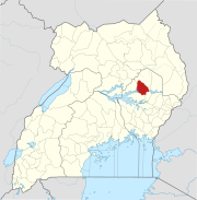
Soroti District is a district in Eastern Uganda. It is named after its chief municipal, administrative and commercial headquarters, Soroti, where the district headquarters are located.

Soroti is a town in Eastern Region of Uganda. It is the main municipal, commercial, and administrative centre of Soroti District, one of the nine administrative districts in the Teso sub-region.

Katakwi is a town in the Eastern Region of Uganda. It is the main municipal, administrative, and commercial center of Katakwi District and the site of the district headquarters. It borders Moroto District.
Amuria is a town in the Eastern Region of Uganda. It is the chief municipal, administrative, and commercial center of Amuria District, in the Teso sub-region.

Amuria District is a district in the Eastern Region of Uganda. The town of Amuria is the site of the district headquarters.
Serere is a town in Eastern Uganda. It is the chief political, administrative and commercial town in Serere District, and the district headquarters are located there. The district is named after the town.
Kumi Town, commonly called Kumi, is a town in the Eastern Region of Uganda. It is the main municipal, administrative, and commercial center in Kumi District and is the site of the district headquarters.
Bukedea is a town in the Eastern Region of Uganda. It is the chief municipal, administrative, and commercial center of Bukedea District, and the district headquarters are located there.
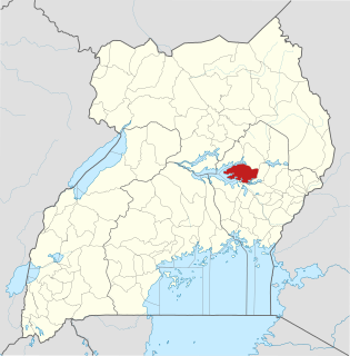
Serere District is a district in Eastern Uganda. It's named after its 'chief town', Serere, where the district headquarters are located.

Ngora District is a district in the Eastern Region of Uganda. The town of Ngora is the site of the district headquarters.
Ngora is a town in the Eastern Region of Uganda. It is the main political, administrative, and commercial centre of Ngora District.
Soroti University (SUN), is a public multi-campus university in Uganda. It is one of the nine public universities and degree-awarding institutions in the country.
Ngora Freda Carr Hospital, commonly known as Ngora Hospital, is a community hospital in Uganda. It is affiliated with the Anglican Church of Uganda. It was founded in 1922. It has 180 beds.
Soroti–Amuria–Abim–Kotido Road is a road in the Eastern and Northern Regions of Uganda. The road connects the towns of Soroti in Soroti District, to Amuria in Amuria District, Abim in Abim District, and Kotido, in Kotido District. Soroti and Amuria lie in the Teso sub-region, while Abim and Kotido are in the Karamoja sub-region.
Soroti Fruit Processing Factory, also Soroti Fruit Factory, is a fruit processing plant in Uganda.
Katakwi General Hospital, also Katakwi Hospital is a government-owned hospital in the Eastern Region of Uganda.
The Jinja–Iganga–Bugiri–Tororo Road is a road in the Eastern Region of Uganda, connecting the towns of Jinja and Tororo. Sometimes referred to as Tororo–Jinja Road, it is a busy transport corridor, connecting traffic from neighboring Kenya, and northeastern Uganda to Jinja, a major commercial and industrial center, and ultimately to Kampala, the country's capital and points beyond.
Terrewode Women's Community Hospital, is a community hospital, under construction in Uganda, that specializes in the prevention, treatment, surgical correction and rehabilitation of obstetric fistula and its complications.