Archer, Nebraska | |
|---|---|
 | |
 Archer  Archer | |
| Coordinates: 41°10′00″N98°08′20″W / 41.16667°N 98.13889°W | |
| Country | United States |
| State | Nebraska |
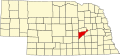
| County | Merrick |
| Area | |
• Total | 1.00 sq mi (2.60 km2) |
| • Land | 1.00 sq mi (2.60 km2) |
| • Water | 0 sq mi (0.00 km2) |
| Elevation | 1,745 ft (532 m) |
| Population | |
• Total | 68 |
| • Density | 67.8/sq mi (26.19/km2) |
| Time zone | UTC-6 (Central (CST)) |
| • Summer (DST) | UTC-5 (CDT) |
| ZIP code | 68816 |
| FIPS code | 31-01920 |
| GNIS feature ID | 2583872 [2] |
Archer is an unincorporated community and census-designated place in northwestern Merrick County, Nebraska, United States. As of the 2020 census the population was 68. [3] The Archer post office carries the ZIP Code 68816. [4]