Ardeth Lake

Last updated
Ardeth Lake
USA Idaho location map.svg
Red pog.svg
Ardeth Lake
Location in Idaho
Usa edcp relief location map.png
Red pog.svg
Ardeth Lake
Location in the United States
Location Boise County, Idaho
Coordinates 43°57′54″N115°00′51″W / 43.9650176°N 115.0142895°W / 43.9650176; -115.0142895 Coordinates: 43°57′54″N115°00′51″W / 43.9650176°N 115.0142895°W / 43.9650176; -115.0142895 [1]
Type Glacial
Primary inflows Tenlake Creek
Primary outflows Tenlake Creek to South Fork of Payette River
Basin  countries United States
Max. length0.50 mi (0.80 km)
Max. width0.34 mi (0.55 km)
Surface area78.5 acres (31.8 ha) [2]
Surface elevation8,232 ft (2,509 m) [1]

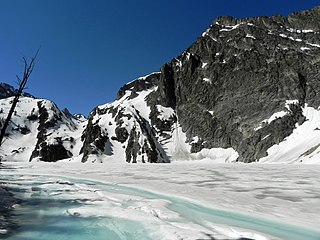
Ardeth Lake is an alpine lake in Boise County, Idaho, United States, located high in the Sawtooth Mountains in the Sawtooth National Recreation Area. The lake is approximately 18 miles (29 km) south of Stanley. Ardeth Lake is most easily accessed from trailheads in the Sawtooth Valley, which are accessed from State Highway 75 or from the Grandjean trailhead to the northwest off of State Highway 21. [3]

Alpine lake

Alpine lakes are classified as lakes or reservoirs at high altitudes, usually starting around 5,000 feet in elevation above sea level or above the tree line.

Boise County, Idaho County in the United States

Boise County is a rural mountain county in the U.S. state of Idaho. As of the 2010 United States Census, the population was 7,028. The county seat is Idaho City, which is connected through a series of paved and unpaved roads to Lowman, Centerville, Placerville, Pioneerville, Star Ranch, Crouch, Garden Valley, and Horseshoe Bend. The elevated central basin area rises 1,700 feet higher than Horseshoe Bend for instance and thus receives significantly more snow during the winter. Star Ranch, Placerville, and Centerville altitudes average 4,300 above sea level whereas Horseshoe Bend is 1,700 feet lower, Garden Valley is 1,157 feet lower, and Idaho City is 400 feet lower. Snow volumes around the county are best illustrated by the county Snow Load Map. Placerville roofs must be designed to withstand 150 pounds per square foot of snow whereas Horseshoe Bend is 1/3 that amount at 52.

Idaho State of the United States of America

Idaho is a state in the northwestern region of the United States. It borders the state of Montana to the east and northeast, Wyoming to the east, Nevada and Utah to the south, and Washington and Oregon to the west. To the north, it shares a small portion of the Canadian border with the province of British Columbia. With a population of approximately 1.7 million and an area of 83,569 square miles (216,440 km2), Idaho is the 14th largest, the 12th least populous and the 7th least densely populated of the 50 U.S. states. The state's capital and largest city is Boise.

Contents

With a surface elevation of 8,228 feet (2,508 m) above sea level, Ardeth Lake often remains frozen into early summer. At the southern end of the lake is Glens Peak at 10,053 feet (3,064 m) in elevation.

Ardeth Lake is in the central Sawtooth Wilderness, and wilderness permit can be obtained at trailheads.

Sawtooth Wilderness a wilderness area in the US state of Idaho

The Sawtooth Wilderness is a federally-protected wilderness area that covers 217,088 acres (87,852 ha) of the state of Idaho. Managed by the U.S. Forest Service in the U.S. Department of Agriculture, it was designated the Sawtooth Primitive Area in 1937 to preserve the exceptional scenic beauty of the Sawtooth Mountains. On August 22, 1972 Public Law 92-400 designated the Primitive Area as the Sawtooth Wilderness and part of the newly created Sawtooth National Recreation Area. As part of the National Wilderness Preservation System, the Sawtooth Wilderness is an area where human development and use are restricted and people are to remain only visitors. According to the United States Environmental Protection Agency, the Sawtooth Wilderness has some of the clearest air in the lower 48 states.

See also

Sawtooth National Forest A national forest located in the US states of Idaho and Utah

Sawtooth National Forest is a National Forest that covers 2,110,408 acres in the U.S. states of Idaho and Utah. Managed by the U.S. Forest Service in the U.S. Department of Agriculture, it was originally named the Sawtooth Forest Reserve in a proclamation issued by President Theodore Roosevelt on May 29, 1905. On August 22, 1972 a portion of the forest was designated as the Sawtooth National Recreation Area (SNRA), which includes the Sawtooth, Cecil D. Andrus–White Clouds, and Hemingway–Boulders wilderness areas. The forest is managed as four units: the SNRA and the Fairfield, Ketchum, and Minidoka Ranger Districts.

Sawtooth National Recreation Area A national recreation area managed by the US Forest Service in the US state of Idaho

The Sawtooth National Recreation Area (SNRA) is a National Recreation Area located in central Idaho, United States that is managed as part of Sawtooth National Forest. The recreation area, established on August 22, 1972, is managed by the U.S. Forest Service, and includes the Sawtooth, Hemingway–Boulders, and Cecil D. Andrus–White Clouds wilderness areas. Activities within the 730,864-acre (2,957.70 km2) recreation area include hiking, backpacking, White water rafting, camping, rock climbing, kayaking, mountain biking, fishing, and hunting.

Sawtooth Range (Idaho) mountain range in the US state of Idaho

The Sawtooth Range is a mountain range of the Rocky Mountains in central Idaho, United States, reaching a maximum elevation of 10,751 feet (3,277 m) at the summit of Thompson Peak. It encompass an area of 678 square miles (1,756 km2) spanning parts of Custer, Boise, Blaine, and Elmore counties, and is bordered to the east by the Sawtooth Valley. Much of the mountain range is within the Sawtooth Wilderness, part of the Sawtooth National Recreation Area and Sawtooth National Forest.

Related Research Articles

Sawtooth Lake

Sawtooth Lake is an alpine lake in Custer County, Idaho, United States, located high in the Sawtooth Mountains in the Sawtooth National Recreation Area. The lake is approximately 6.8 miles (10.9 km) southwest of Stanley. A trail from the Iron Creek trailhead and campground leads approximately 5 miles to Sawtooth Lake. The Iron Creek trailhead can be accessed from State Highway 21 via Sawtooth National Forest road 619.

Goat Lake (Sawtooth Wilderness)

Goat Lake is an alpine lake in Custer County, Idaho, United States, located high in the Sawtooth Mountains in the Sawtooth National Recreation Area. The lake is approximately 6 miles (9.7 km) southwest of Stanley. The lake is most easily accessed from the Iron Creek trailhead, which can be accessed from State Highway 21 via Sawtooth National Forest road 619.

Alice Lake (Sawtooth Wilderness) lake in Blaine County, Idaho, USA

Alice Lake is an alpine lake in Blaine County, Idaho, United States, located high in the Sawtooth Mountains in the Sawtooth National Recreation Area. The lake is one of the largest in the Sawtooth Wilderness and is most easily accessed via the trailhead at Pettit Lake, accessed from State Highway 75 via Sawtooth National Forest road 208.

Alpine Lake (Northern Sawtooth Wilderness) lake in Custer County, Idaho, USA in the Northern Sawtooth Wilderness

Alpine Lake is an alpine lake in Custer County, Idaho, United States, located high in the Sawtooth Mountains in the Sawtooth National Recreation Area. The lake is approximately 6.3 mi (10.1 km) southwest of Stanley. A trail from the Iron Creek trailhead and campground leads approximately 5 miles (8.0 km) to Sawtooth Lake. The Iron Creek trailhead can be accessed from State Highway 21 via Sawtooth National Forest road 619. There is another lake with the name Alpine Lake in the central part of the Sawtooth Wilderness.

Alpine Lake (Central Sawtooth Wilderness) lake in Custer County, Idaho, USA in the Central Sawtooth Wilderness

Alpine Lake is an alpine lake in Custer County, Idaho, United States, located high in the Sawtooth Mountains in the Sawtooth National Recreation Area. The lake is approximately 11.4 miles (18.3 km) southwest of Stanley.

Edith Lake is a small alpine lake in Custer County, Idaho, United States, located high in the Sawtooth Mountains in the Sawtooth National Recreation Area. The lake is approximately 16.5 miles (26.6 km) south of Stanley. A trail from the Yellow Belly Lake and Pettit Lake trailheads leads towards Edith Lake via Farley Lake. These trailheads can be accessed from State Highway 75 via Sawtooth National Forest road 208.

Farley Lake

Farley Lake is a small alpine lake in Custer County, Idaho, United States, located high in the Sawtooth Mountains in the Sawtooth National Recreation Area. The lake is approximately 16.5 miles (26.6 km) south of Stanley. There are two small islands in Farley Lake, the largest of which is only about 200 feet (61 m) long. A trail from the Yellow Belly Lake and Pettit Lake trailheads leads towards Edith Lake via Farley Lake. These trailheads can be accessed from State Highway 75 via Sawtooth National Forest road 208.

Toxaway Lake (Idaho) lake in Idaho

Toxaway Lake is an alpine lake in the western United States, in Custer County, Idaho. Located high in the Sawtooth Mountains in the Sawtooth National Recreation Area, it is approximately 17 miles (27 km) south of Stanley. The lake's surface elevation is 8,323 ft (2,537 m) above sea level.

Pettit Lake

Pettit Lake is a large alpine lake in Blaine County, Idaho, United States, located in the Sawtooth Valley in the Sawtooth National Recreation Area. The lake is approximately 16 miles (26 km) south of Stanley and 33 miles (53 km) northwest of Ketchum.

Elk Lake is an alpine lake in Boise County, Idaho, United States, located in the Sawtooth Mountains in the Sawtooth National Recreation Area. The lake is approximately 15 miles (24 km) southwest of Stanley and 9.5 miles (15.3 km) southeast of Grandjean. Located in the remote central Sawtooth Wilderness, Elk Lake is most easily reached from the Grandjean trailhead to the northwest and downstream along the South Fork of the Payette River.

Hell Roaring Lake

Hell Roaring Lake is an alpine lake in Custer County, Idaho, United States, located in the Sawtooth Mountains in the Sawtooth National Recreation Area. The lake is approximately 13.3 miles (21.4 km) southwest of Stanley. The lake can be accessed from State Highway 75 in the Sawtooth Valley. There is a trailhead about two miles from the lake on Sawtooth National Forest road 097, which is a high clearance road. There is another trailhead about two miles further downstream along forest road 210 for those who cannot drive road 097 as well as horses.

Imogene Lake is an alpine lake in Custer County, Idaho, United States, located in the Sawtooth Mountains in the Sawtooth National Recreation Area. The lake is approximately 15 miles (24 km) southwest of Stanley. The lake can be accessed from State Highway 75 in the Sawtooth Valley. There is a trailhead downstream of Hell Roaring Lake at the end of Sawtooth National Forest road 097, which is a high clearance road. There is another trailhead about two miles further downstream along forest road 210 for those who cannot drive road 097 as well as horses.

Rock Island Lake is a small alpine lake in Elmore County, Idaho, United States, located in the Sawtooth Mountains in the Sawtooth National Recreation Area. The lake is accessed from Sawtooth National Forest trail 459 along Johnson Creek.

Johnson Lake is a small alpine lake in Elmore County, Idaho, United States, located in the Sawtooth Mountains in the Sawtooth National Recreation Area. The lake is accessed from Sawtooth National Forest a cutoff of trail 459 along Johnson Creek.

Baron Lake (Idaho)

Baron Lake is an alpine lake in Boise County, Idaho, United States, located in the Sawtooth Mountains in the Sawtooth National Recreation Area. Sawtooth National Forest trail 101 goes to the lake.

Little Baron Lake is a small alpine lake in Boise County, Idaho, United States, located in the Sawtooth Mountains in the Sawtooth National Recreation Area. The lake is most easily accessed from Sawtooth National Forest trail 101.

Regan Lake is a small alpine lake in Boise County, Idaho, United States, located in the Sawtooth Mountains in the Sawtooth National Recreation Area. The lake is most easily accessed from Sawtooth National Forest trail 453.

The Trail Creek Lakes are a series of five small alpine glacial lakes in Boise County, Idaho, United States, located in the Sawtooth Mountains in the Sawtooth National Recreation Area. The lakes are on Trail Creek, which is a tributary of the South Fork Payette River. The lakes can be accessed from Sawtooth National Forest trail 453.

The Trailer Lakes are a series of three small alpine glacial lakes in Boise County, Idaho, United States, located in the Sawtooth Mountains in the Sawtooth National Recreation Area. The Trailer Lakes are in the Trail Creek watershed, which is a tributary of the South Fork Payette River. The lakes are most easily accessed from Sawtooth National Forest trail 453.

References

  1. 1 2 "Ardeth Lake". Geographic Names Information System . United States Geological Survey.
  2. "Ardeth Lake". Idaho Department of Fish and Game. Retrieved November 18, 2018.
  3. Sawtooth National Forest. “Sawtooth National Forest” [map].1:126,720, 1”=2 miles. Twin Falls, Idaho: Sawtooth National Forest, United States Forest Service, 1998.