
South Wollo is a zone in the Amhara Region of Ethiopia. It acquired its name from the former province of Wollo. South Wollo is bordered on the south by North Shewa and the Oromia Region, on the west by East Gojjam, on the northwest by South Gondar, on the north by North Wollo, on the northeast by Afar Region, and on the east by the Oromia Special Zone and the Argobba special woreda. Its highest point is Mount Tabor in Amhara Sayint, 4247 meter above sea level. Towns in South Wollo include Kombolcha, Hayq, Dessie,[Gemba {Tuluawliya}] Wuchale, Aqesta,SaintAjibar, Degolo and Mekaneselam.
North Shewa is a zone in the Amhara Region of Ethiopia. North Shewa takes its name from the kingdom and former province of Shewa. The Zone is bordered on the south and the west by the Oromia Region, on the north by South Wollo, on the northeast by the Oromia Zone, and on the east by the Afar Region. The highest point in the Zone is Mount Abuye Meda, which is found in the Gish woreda; other prominent peaks include Mount Megezez. Towns in North Shewa include Ankober, Debre Birhan, and Shewa Robit.
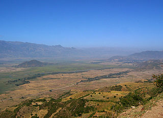
The Oromia Zone is a zone in Amhara Region of Ethiopia. Oromia is named for the Oromo people, who settled along the edge of the Ethiopian Highlands that form this Zone. Oromia Zone is bordered on the southwest by North Shewa Zone, on the northwest by South Wollo and Argobba special woreda, and on the east by the Afar Region. The Zone consists of 7 Woredas which are Artuma Fursi, Bati, Bati Town, Dewa Cheffa, Dewa Harewa, Jilye Tumuga and Kemisie town. Kemise is the administrative center of the Zone.

Gabi Rasu, also known as Administrative Zone 3, is a zone in the Afar Region of Ethiopia. This zone is bordered on the south by the Oromia Region, on the southwest by the Amhara Region, on the west by Hari Rasu, on the north by Awsi Rasu, and on the east by the Somali Region.
Kalu also known as Harbu is one of the woredas in the Amhara Region of Ethiopia. Part of the Debub Wollo Zone, Kalu is bordered on the west by Dessie Zuria, on the north by Were Babu, on the south and east by the Oromia Zone, on the southeast by Argobba special woreda, and on the southwest by Abuko. The administrative center for this woreda is Harbu; other towns in Kalu include Ancharo, Gerba, and Degan. A highway linking Kombolcha and Afar bisects Kalu to two parts.
Kelala is one of the woredas in the Amhara Region of Ethiopia. Part of the Debub Wollo Zone, Kelala is bordered on the south by the Semien Shewa Zone, on the southwest by the Walaqa River which separates it from the Oromia Region, on the west by Wegde, on the north by Legambo, on the northeast by Legahida, and on the east by Jama. Towns in Kelala include Kelala and Liguama. Kelala town is 157 km far from Dessie in the Western direction.
Efratana Gidim is a woreda in Amhara Region, Ethiopia. It is named after two historic districts that were part of the former autonomous kingdom of Shewa, Efrata and Gedem. Part of the Semien Shewa Zone, Efratana Gidim is bordered on the south by Kewet, on the southwest by Menz Mam Midir, on the west by Menz Gera Midir, on the north by Antsokiyana Gemza, and on the east by the Oromia Zone. The administrative center of this woreda is Ataye (Effeson); other towns in Efratana Gidim include Jewha and Karakore.
Kewet is a woreda in Amhara Region, Ethiopia. Part of the Semien Shewa Zone, Kewet is bordered on the southwest by Termaber, on the northwest by Menz Mam Midir, on the north by Efratana Gidim, and on the east by Afar Region. The major town in Kewet is Shewa Robit.
Tarmaber is a woreda in Amhara Region, Ethiopia. It includes a homonymous mountain pass and road tunnel. Located at the eastern edge of the Ethiopian Highlands in the Semien Shewa Zone, Termaber is bordered on the south by Ankober, on the southwest by Basona Werana, on the west by Mojana Wadera, on the northwest by Menz Mam Midir, on the northeast by Kewet, and on the southeast by the Afar Region. Towns in this woreda include Debre Sina and Doqaqit.
Ankober is a woreda in the Amhara Region of Ethiopia. Located at the eastern edge of the Ethiopian highlands in the North Shewa Zone, Ankober is bordered on the south by Asagirt, on the west by Basona Werana, on the north by Termaber, and on the east by the Afar Region. Towns in Ankober include Aliyu Amba, Ankober, Gorgo and Haramba.
Hagere Mariamna Kesem or alternatively called Hagere Mariam and Kesem, is a woreda in Amhara Region, Ethiopia. Part of the Semien Shewa Zone, Hagere Mariamna Kesem is bordered on the south by the Germama river which separates it from Menjarna Shenkora, on the west by the Oromia Region, on the north by Angolalla Tera, on northeast by Asagirt, and on the east by Berehet. The administrative center of this woreda is Shola Gebeya; other towns include Kese Koremash.
Berehet is one of the woredas in the Amhara Region of Ethiopia. Part of the Semien Shewa Zone, Berehet is bordered on the south by the Germama River which separates it from Menjarna Shenkora, on the west by Hagere Mariamna Kesem, on the north by Asagirt, and on the east by the Afar Region. The major town in Berehet is Metiteh Bila.
Minjarna Shenkora, also Menjarna Shenkora is a woreda in Amhara Region, Ethiopia. It is named in part after the historic Shewan district of Minjar, which was the southernmost district of Shewa and near the location of the modern woreda. Located at the southern end of the Semien Shewa Zone, Minjarna Shenkora is bordered on the east, south and west by the Oromia Region, on the northwest by Hagere Mariamna Kesem, and on the northeast by Berehet; the Germama river forms the boundary between this woreda and Hagere Mariamna Kesem and Berehet. The administrative center of this woreda is Arerti; other towns in the woreda include Balchi and Eranbuti.
Dangila is one of the woredas in the Amhara Region of Ethiopia. This woreda is named after the former district, Dangila, which James Bruce notes was in his day known for its breed of sheep. Part of the Agew Awi Zone, Dangila is bordered on the south by Faggeta Lekoma, on the southwest by Guangua, on the northwest by the Jawi, and on the northeast by the Mirab Gojjam Zone. Towns in Dangila include Addis Alem, Dangila and Dek. Part of the Dangila was separated to create Jawi woreda.
Guba Koricha is a Aanaa in Oromia Regional State, Ethiopia. Located in the West Hararghe Zone, Guba Koricha, according to the OCHA map (2005) is bordered on the south by Darolebu, on the southwest by the Arsi Zone, on the west by the Afar Region, on the north by Mieso, on the northeast by Chiro, on the east by Habro, and on the southeast by Boke. Woreda of Anchar was separated from Guba Koricha.
Daru labu is a woreda in the Oromia Region of Ethiopia. Located in the West Hararghe Zone, Daru labu is bordered on the south by the Shebelle River which separates it from the Bale Zone, on the west by the Arsi Zone, on the northwest by Guba Koricha, on the north by the Habro, and on the east by Boke. Towns in Darolebu include Mechara and Micheta.
Abichuna Gne'a is a woreda in Oromia Region, Ethiopia. This woreda is named in part for the Abichu Oromo. Part of the Kaba Shewa Zone, Abichu woreda is bordered on the south by Kembibit, on the west by Wuchalena Jido, and on the north and east by the Amhara Region. The major town in Abichu is Mendida.
Bati is a district in the Oromia Zone of the Amhara region of Ethiopia. Bati is bordered on the south by Dawa Harewa, on the southeast by the Argobba special woreda, on the west and north by the Debub Wollo Zone, and on the east by the Afar Region. Towns in this woreda include its administrative center, the market town of Bati. The towns of Degan and Gerba were administratively part of Bati before the 2007 census but was then transferred to Kalu woreda.
Artuma Fursi Jilee is a woreda located in the Oromia Zone of the Amhara region of Ethiopia. Artuma Fursi Jilee was bordered on the west by the North Shewa Zone, on the north by Chaffa Gola Dewerahmedo, and on the east by the Afar Region. Towns in Artuma Fursi Jilee included Adebela, Chefa Robit, Kichicho and Senbete. Artuma Fursi Jilee was divided into Artuma Fursi and Jilee Dhummuugaa woredas.
Chaffa Gola Dewerahmedo was a woreda in the Amhara Region of Ethiopia. Part of the Oromia Zone, Chaffa Gola Dewerahmedo was bordered on the south by Artuma Fursi Jilee, on the southwest by the Semien Shewa Zone, on the west by the Debub Wollo Zone, on the north by Baati, and on the east by the Afar Region. Towns in Chaffa Gola Dewerahmedo included Bora and Kamisee; the villages of Shonke and T’ollaha were also located in this woreda, and notable as being communities where the Argobba language is spoken. Chaffa Gola Dewerahmedo was divided for Dawa Chaffa and Dawa Harewa woredas and Kamisee town.