Arkansas Post, Arkansas

Last updated

Arkansas Post, Arkansas
BAYOUS AROUND ARKANSAS POST.jpg
Bayous around Arkansas Post
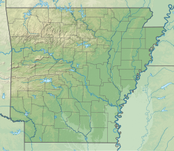
USA Arkansas relief location map.svg
Red pog.svg
Arkansas Post
Location in Arkansas
Coordinates: 34°01′25″N91°20′37″W / 34.02361°N 91.34361°W / 34.02361; -91.34361
Country Flag of the United States.svg  United States
State Flag of Arkansas.svg  Arkansas
County Arkansas
Township Arkansas
FoundedDecember 27, 1831 (1831-12-27)
Elevation
[1]
177 ft (54 m)
Time zone UTC−06:00 (CST)
  Summer (DST) UTC−05:00 (CDT)
GNIS feature ID66948 [1]
Highways Arkansas 169.svg Highway 169

Arkansas Post is an unincorporated community located along the north side of the Arkansas River in Arkansas County, Arkansas. [1] It is home to the Arkansas Post National Memorial.
Contents

History

In 1805 the U.S. government established a store at the location, but was closed in 1810, due to competition from private merchants. [2] Nathaniel Pryor, [3] who participated in the Lewis and Clark expedition, and Samuel B. Richards of Natchez established a store at the location after the War of 1812. [4] Present-day Arkansas Post was founded on December 27, 1831, with the establishment of the first U.S. post office in the Arkansas Territory. [5]

Infrastructure

Highway 169 terminates at Arkansas Post. [6]

Notable residents

Related Research Articles

<span class="mw-page-title-main">Arkansas</span> U.S. state

Arkansas is a landlocked state in the South Central region of the Southern United States. It borders Missouri to the north, Tennessee and Mississippi to the east, Louisiana to the south, Texas to the southwest, and Oklahoma to the west. Its name derives from the Osage language, and refers to their relatives, the Quapaw people. The state's diverse geography ranges from the mountainous regions of the Ozark and Ouachita Mountains, which make up the U.S. Interior Highlands, to the densely forested land in the south known as the Arkansas Timberlands, to the eastern lowlands along the Mississippi River and the Arkansas Delta.

<span class="mw-page-title-main">Indian Territory</span> Historic sovereign territory set aside for Native American nations, 1834–1907

Indian Territory and the Indian Territories are terms that generally described an evolving land area set aside by the United States government for the relocation of Native Americans who held original Indian title to their land as an independent nation-state. The concept of an Indian territory was an outcome of the U.S. federal government's 18th- and 19th-century policy of Indian removal. After the American Civil War (1861–1865), the policy of the U.S. government was one of assimilation.

<span class="mw-page-title-main">Clark County, Arkansas</span> County in Arkansas, United States

Clark County is a county located in the south-central part of the U.S. state of Arkansas. As of the 2020 census, the population was 21,446. The county seat is Arkadelphia. The Arkadelphia, AR Micropolitan Statistical Area includes all of Clark County.

<span class="mw-page-title-main">Camden, Arkansas</span> City in Arkansas, United States

Camden is a city in and the county seat of Ouachita County in the south-central part of the U.S. state of Arkansas. The city is located about 100 miles south of Little Rock. Situated on bluffs overlooking the Ouachita River, the city developed because of the river.

<span class="mw-page-title-main">Pryor Creek, Oklahoma</span> City in Oklahoma, United States

Pryor Creek or Pryor is a city in and county seat of Mayes County, Oklahoma, United States. The population was 8,659 at the 2000 census and 9,539 in the 2010 census.

<span class="mw-page-title-main">Quapaw, Oklahoma</span> Town in the U.S. state of Oklahoma and capital of the Quapaw Nation

Quapaw, officially the Town of Quapaw, is a town in Ottawa County, Oklahoma, United States, which serves as the capital of the Quapaw Nation. Located about 9 miles (14 km) northeast of Miami, it is part of the Joplin, Missouri metropolitan area. Incorporated in 1917, Quapaw's population was 811 in 2020.

<span class="mw-page-title-main">Arkansas Post</span> Historic site and museum in Arkansas County, Arkansas

The Arkansas Post, formally the Arkansas Post National Memorial, was the first European settlement in the Mississippi Alluvial Plain and present-day U.S. state of Arkansas. In 1686, Henri de Tonti established it on behalf of Louis XIV of France for the purpose of trading with the Quapaw Nation. The French, Spanish, and Americans, who acquired the territory in 1803 with the Louisiana Purchase, considered the site of strategic value. It was the capital of Arkansas from 1819 until 1821 when the territorial government relocated to Little Rock.

<span class="mw-page-title-main">Quapaw</span> Native American tribe

The Quapaw or Arkansas, officially the Quapaw Nation, is a U.S. federally recognized tribe comprising about 5,600 citizens. Also known as the Ogáxpa or “Downstream” people, their ancestral homelands are traced from what is now the Ohio River, west to the Mississippi River to present-day St. Louis, south across present-day Arkansas and eastern and southern Oklahoma. The government forcibly removed them from Arkansas Territory in 1834. The tribal capital is Quapaw, Oklahoma.

<span class="mw-page-title-main">Nathaniel Hale Pryor</span>

Nathaniel Hale Pryor (1772–1831) was an American explorer, who served as Sergeant in the Lewis and Clark Expedition.

<span class="mw-page-title-main">Fort Jefferson (Kentucky)</span> 1779 fort and 1781 battle in Kentucky

Fort Jefferson was a town on the Mississippi River, about one mile south of Wickliffe, Kentucky in southwestern Ballard County.

<span class="mw-page-title-main">History of Arkansas</span>

The history of Arkansas began millennia ago when humans first crossed into North America. Many tribes used Arkansas as their hunting lands but the main tribe was the Quapaw, who settled in the Arkansas River delta upon moving south from Illinois. Early French explorers gave the territory its name, a corruption of Akansea, which is a phonetic spelling from the Illinois language word for the Quapaw. This phonetic heritage explains why "Arkansas" is pronounced so differently than the U.S. state of "Kansas" even though they share the same spelling.

Nady is an unincorporated community in Arkansas County, Arkansas, United States. It is the location of a National Historic Landmark, the Menard–Hodges site. The environs of Nady, at the southern tip of the Little Prairie, are in the portion of Arkansas that saw the earliest European settlement in what is now the state of Arkansas, including Tonty’s 1686 post. The Menard-Hodges archeological site, about one-half mile southwest of Wallace-Menard-Coose Cemetery, along with the adjacent Wallace Bottom archeological site, appear to be the locations of the late 1600s Quapaw village of Osotouy, Tonty’s 1686 Post, and the early to mid-1700s French Arkansas Post.

<span class="mw-page-title-main">Arkansas Delta</span> Natural region of Arkansas

The Arkansas Delta is one of the six natural regions of the state of Arkansas. Willard B. Gatewood Jr., author of The Arkansas Delta: Land of Paradox, says that rich cotton lands of the Arkansas Delta make that area "The Deepest of the Deep South."

Events from the year 1805 in the United States.

Events from the year 1839 in the United States.

On the eve of the American Civil War in 1861, a significant number of Indigenous peoples of the Americas had been relocated from the Southeastern United States to Indian Territory, west of the Mississippi. The inhabitants of the eastern part of the Indian Territory, the Five Civilized Tribes, were suzerain nations with established tribal governments, well established cultures, and legal systems that allowed for slavery. Before European Contact these tribes were generally matriarchial societies, with agriculture being the primary economic pursuit. The bulk of the tribes lived in towns with planned streets, residential and public areas. The people were ruled by complex hereditary chiefdoms of varying size and complexity with high levels of military organization.

Huntington is a ghost town in Bolivar County, Mississippi, United States.

Saracen, also known as Sarazin, Sarasen and Sarasin, was a French-Quapaw man known during the 1800s by some European Americans as an honorary "chief". Saracen witnessed the removal of his people from traditional land in Arkansas to Indian Territory. Because of his mixed-blood, he had no hereditary right to the role of chief. But Anglo-Americans considered him a chief because of his deeds.

Saracen Casino Resort is a casino in Pine Bluff, Arkansas, United States. The first purpose-built casino in Arkansas is owned by the Quapaw Nation, and named for Saracen, a Quapaw chief in the 1800s.

Joseph Tali Byrd is a Cherokee Nation and Quapaw Nation politician who served as the Quapaw Nation Chairman from 2020 until his resignation in 2023.

References

  1. 1 2 3 U.S. Geological Survey Geographic Names Information System: Arkansas Post, Arkansas
  2. Morris, Wayne. “Traders and Factories on the Arkansas Frontier, 1805-1822.” The Arkansas Historical Quarterly, vol. 28, no. 1, 1969, pp. 28–48. JSTOR website Retrieved 11 Jan. 2023.
  3. “Captain Nathaniel Pryor.” The American Historical Review, vol. 24, no. 2, 1919, pp. 253–65. JSTOR website Retrieved 11 Jan. 2023.
  4. Grant Foreman. (1926). Pioneer days in the early Southwest. Cleveland, Ohio: Arthur H. Clark Company. p. 76. Internet Archive website Retrieved 11 January 2023.
  5. Record of Appointment of Postmasters, 1832-1971. NARA Microfilm Publication, M841, 145 rolls. Records of the Post Office Department, Record Group Number 28, Washington, D.C.: National Archives
  6. Arkansas Atlas and Gazetteer (Map) (Second ed.). DeLorme. § 5.
  7. Matheson, Luke (August 13, 2019). "Who Was Chief Saracen of the Quapaw Tribe?". Pine Bluff Commercial.

Further reading

Commons-logo.svg Media related to Arkansas Post, Arkansas at Wikimedia Commons