Arkwright Town Junction

Last updated

Duckmanton Junction
goods-only line
BSicon -STRq.svgBSicon STRq red.svg
line with goods and
passenger service
lifted line
BSicon exSTRq grey.svg
1955
BSicon CONTg red.svg
Great Central Main Line
BSicon STR red.svg
to Foxlow Junction
BSicon CONTgq.svgBSicon STRq.svg
BSicon BRIDGE.svg
BSicon STR red.svg
BSicon STRq.svg
BSicon kSTR2+r.svgBSicon kSTRc3.svg
former Midland Railway
Staveley Central
BSicon BHF red.svgBSicon kSTR+4.svg
to Seymour Junction
BSicon kSTR3 red.svg
BSicon STR red.svg
BSicon lCONTfg.svg
GC to Chesterfield Central
BSicon CONTgq red.svgBSicon kSTRr+1 red.svg
BSicon STR red.svg
BSicon kSTRc4 red.svg
BSicon LKRW+l red.svgBSicon LKRWr red.svg
Duckmanton North Jn
BSicon STR red.svg
BSicon kSTR2.svg
BSicon kSTRc1.svg
BSicon STRc2.svg
BSicon STR red.svg
BSicon STR3+l.svg
BSicon STR+l.svg
BSicon kSTRl+4.svg
BSicon kSTR2+r.svgBSicon kSTRc3.svg
Duckmanton East Jn
BSicon STRc2.svg
BSicon BRIDGE3+1u.svg
BSicon STR3+1.svg
BSicon BS2c2.svg
BSicon STR red.svg
BSicon STRc4.svg
BSicon BS2r.svg
BSicon kSTR+4.svg
BSicon STR2+1.svg
BSicon STRc34.svg
BSicon STR~L.svg
BSicon STR red.svg
BSicon STR~R.svgBSicon STR.svg
Duckmanton South Jn
BSicon STRc1.svg
BSicon BS2+l.svg
BSicon STR red.svg
BSicon STR+4.svg
BSicon STRc2 grey.svg
BSicon BS2c4.svg
BSicon RP23+e.svgBSicon SKRZ-G2u.svgBSicon POINTER3.svg
Arkwright Town Junction
A632
BSicon RP2oq.svg
BSicon STR red.svg
BSicon STRc2.svg
BSicon RP2w+1.svg
BSicon STRc4 grey.svg
BSicon STR3+l.svg
BSicon ABZql.svg
BSicon ENDEeq.svg
BSicon exSTRq grey.svg
formerly to
Bolsover South
to
Chesterfield
(Market Place)
BSicon CONTgq.svg
BSicon BRIDGE.svg
BSicon STR red.svg
BSicon STRq.svg
BSicon STRr+1.svg
BSicon lv-BHF~g.svg
BSicon STR+r.svg
BSicon STRc4.svg
Arkwright Town
BSicon STR red.svgBSicon KBSTe.svg
Arkwright Colliery (1938)
BSicon LSTR red.svg
BSicon CONT2 red.svg
BSicon STRc3 red.svg
BSicon STR red.svg
BSicon STRc1 red.svg
BSicon STR+4 red.svg
BSicon STR red.svg
Heath
BSicon BHF red.svg
BSicon CONTf red.svg
1965
BSicon CONTg red.svg
Great Central Main Line
BSicon STR red.svg
to Foxlow Junction
BSicon CONTgq.svgBSicon STRq.svg
BSicon BRIDGE.svg
BSicon STR red.svg
BSicon STRq.svg
BSicon kSTR2+r.svgBSicon kSTRc3.svg
former Midland Railway
Staveley Central
BSicon exlBHF.svg
BSicon STR red.svg
BSicon kSTR+4.svg
to Seymour Junction
BSicon STR red.svg
BSicon exkSTR3 grey.svg
BSicon lCONTfg.svg
GC to Chesterfield Central
BSicon exCONTgq grey.svgBSicon exkSTRr+1 grey.svg
BSicon STR red.svg
BSicon exkSTRc4 grey.svg
BSicon LKRW+l red.svgBSicon LKRWr red.svg
Duckmanton North Jn
BSicon STR red.svg
BSicon kSTR2.svg
BSicon kSTRc1.svg
BSicon exSTRc2 grey.svg
BSicon STR red.svg
BSicon exSTR+l grey.svg
BSicon kSTRl+4.svg
BSicon exSTR3+l grey.svg
BSicon kSTR2+r.svgBSicon kSTRc3.svg
Duckmanton East Jn
BSicon exSTRc2 grey.svg
BSicon MASKm.svg
BSicon STR red.svg
BSicon exBS2c2 grey.svg
BSicon exSTR3+1 grey.svg
BSicon exSTRc4 grey.svg
BSicon exBS2r grey.svg
BSicon kSTR+4.svg
BSicon exSTR2+1 grey.svg
BSicon exSTRc3 grey.svg
BSicon exSTRc4 grey.svg
BSicon exSTR~L grey.svg
BSicon STR red.svg
BSicon exSTR~R grey.svgBSicon STR.svg
Duckmanton South Jn
BSicon exSTRc1 grey.svg
BSicon exBS2+l grey.svg
BSicon STR red.svg
BSicon exSTR+4 grey.svg
BSicon STRc2 grey.svg
BSicon exBS2c4 grey.svg
BSicon RP23+e.svgBSicon SKRZ-G2u.svgBSicon POINTER3.svg
Arkwright Town Junction
A632
BSicon RP2oq.svg
BSicon STR red.svg
BSicon STRc2.svg
BSicon RP2w+1.svg
BSicon STRc4 grey.svg
BSicon STR3+l.svg
BSicon ABZql.svg
BSicon ENDEeq.svg
BSicon exSTRq grey.svg
formerly to
Bolsover South
to
Chesterfield
(Market Place)
BSicon ENDEaq.svg
BSicon exSTRq grey.svg
BSicon BRIDGE.svg
BSicon STR red.svg
BSicon STRq.svg
BSicon STRr+1.svg
BSicon exlv-BHF~g.svg
BSicon STR+r.svg
BSicon STRc4.svg
Arkwright Town
BSicon STR red.svgBSicon KBSTe.svg
Arkwright Colliery (1938)
BSicon LSTR red.svg
BSicon exCONT2 grey.svg
BSicon exSTRc3 grey.svg
BSicon STR red.svg
BSicon exSTRc1 grey.svg
BSicon STR red.svg
BSicon exSTR+4 grey.svg
Heath
BSicon exlBHF.svg
BSicon STR red.svg
BSicon CONTf red.svg
1972
BSicon CONTg.svg
Great Central Main Line
BSicon STR.svg
to Foxlow Junction
BSicon CONTgq.svgBSicon STRq.svgBSicon KRZo.svgBSicon kSTR2+r.svgBSicon kSTRc3.svg
former Midland Railway
site of Staveley Central
BSicon STR.svg
BSicon exlBHF grey.svg
BSicon kSTR+4.svg
to Seymour Junction
BSicon STR.svg
BSicon exkSTR3 grey.svg
BSicon lCONTfg.svg
GC to Chesterfield Central
BSicon exCONTgq grey.svgBSicon exkSTRr+1 grey.svg
BSicon STR.svg
BSicon exkSTRc4 grey.svg
BSicon LKRW+l.svgBSicon LKRWr.svg
Duckmanton North Jn
BSicon kSTR2.svg
BSicon exSTR grey.svg
BSicon kSTRc1.svg
BSicon exSTRc2 grey.svg
BSicon exSTR grey.svg
BSicon exSTR+l grey.svg
BSicon kSTRl+4.svg
BSicon exSTR3+l grey.svg
BSicon kSTR2+r.svgBSicon kSTRc3.svg
Duckmanton East Jn
BSicon exSTRc2 grey.svg
BSicon MASKm.svg
BSicon exSTR grey.svg
BSicon exBS2c2 grey.svg
BSicon exSTR3+1 grey.svg
BSicon exSTRc4 grey.svg
BSicon exBS2r grey.svg
BSicon kSTR+4.svg
BSicon exSTR2+1 grey.svg
BSicon exSTRc3 grey.svg
BSicon exSTRc4 grey.svg
BSicon exSTR~L grey.svg
BSicon exSTR grey.svg
BSicon exSTR~R grey.svgBSicon STR.svg
Duckmanton South Jn
BSicon exSTRc1 grey.svg
BSicon exBS2+l grey.svg
BSicon exSTR grey.svg
BSicon exSTR+4 grey.svg
BSicon STRc2 grey.svg
BSicon exBS2c4 grey.svg
BSicon RP23+e.svgBSicon SKRZ-G2u.svgBSicon POINTER3.svg
Arkwright Town Junction
A632
BSicon RP2oq.svg
BSicon exSTR grey.svg
BSicon STRc2.svg
BSicon RP2w+1.svg
BSicon STRc4 grey.svg
BSicon STR3+l.svg
BSicon ABZql.svg
BSicon ENDEeq.svg
BSicon exSTRq grey.svg
formerly to
Bolsover South
formerly to
Chesterfield Market Place
BSicon ENDEaq.svg
BSicon exSTRq grey.svg
BSicon MSTRq.svg
BSicon STRq.svg
BSicon exSTR grey.svg
BSicon exlv-BHF~g grey.svg
BSicon STRr+1.svg
BSicon STR+r.svg
BSicon STRc4.svg
site of Arkwright Town
BSicon exSTR grey.svgBSicon KBSTe.svg
Arkwright Colliery (1938)
BSicon exLSTR grey.svg
BSicon exCONT2 grey.svg
BSicon exSTRc3 grey.svg
BSicon exSTR grey.svg
BSicon exSTRc1 grey.svg
BSicon exSTR grey.svg
BSicon exSTR+4 grey.svg
site of Heath
BSicon exBHF grey.svg
BSicon exCONTf grey.svg
1987
BSicon exCONTg grey.svg
Great Central Main Line
BSicon exSTR grey.svg
to Foxlow Junction
BSicon CONTgq.svgBSicon kABZq2.svg
BSicon MSTRq.svg
BSicon STRq.svg
BSicon kSTRc3.svg
BSicon exSTR grey.svg
BSicon kSTR2+r.svgBSicon kSTRc3.svg
former Midland Railway
site of Staveley Central
BSicon kSTR+4.svg
BSicon exBHF grey.svg
BSicon kSTR+4.svg
to Seymour Junction
BSicon STR.svg
BSicon exkSTR3 grey.svg
BSicon lCONTfg.svg
GC to Chesterfield Central
BSicon exCONTgq grey.svgBSicon exkSTRr+1 grey.svg
BSicon STR.svg
BSicon exkSTRc4 grey.svg
BSicon LKRW+l.svgBSicon LKRWr.svg
Duckmanton North Jn
BSicon STR.svg
BSicon exkSTR2 grey.svg
BSicon exkSTRc1 grey.svg
BSicon exSTRc2 grey.svg
BSicon STR.svg
BSicon exSTR+l grey.svg
BSicon exkSTRl+4 grey.svg
BSicon exSTR3+l grey.svg
BSicon exkSTR2+r grey.svgBSicon exkSTRc3 grey.svg
Duckmanton East Jn
BSicon exSTRc2 grey.svg
BSicon MASKm.svg
BSicon STR.svg
BSicon exBS2c2 grey.svg
BSicon exSTR3+1 grey.svg
BSicon exSTRc4 grey.svg
BSicon exBS2r grey.svg
BSicon exkSTR+4 grey.svg
BSicon exSTR2+1 grey.svg
BSicon exSTRc3 grey.svg
BSicon exSTR~L grey.svg
BSicon exSTRc4 grey.svg
BSicon STR.svg
BSicon exSTR~R grey.svgBSicon exSTR grey.svg
Duckmanton South Jn
BSicon exSTRc1 grey.svg
BSicon exBS2+l grey.svg
BSicon STR.svg
BSicon exSTR+4 grey.svg
BSicon STRc2 grey.svg
BSicon exBS2c4 grey.svg
BSicon RP23+e.svg
BSicon RP2oq.svg
BSicon exSTR grey.svg
BSicon POINTER3.svg
Arkwright Town Junction
A632
BSicon SKRZ-G2u.svg
BSicon exSTRc2 grey.svg
BSicon RP2w+1.svg
BSicon STRc4 grey.svg
BSicon exSTR3+l grey.svg
BSicon exABZql grey.svgBSicon exSTRq grey.svg
formerly to
Bolsover South
formerly to
Chesterfield Market Place
BSicon exSTRq grey.svg
BSicon MSTRq.svg
BSicon MASKa.svg
BSicon STRl.svg
BSicon excSTRq grey.svg
BSicon exSTR grey.svg
BSicon STR+r.svg
BSicon exlv-BHF~g grey.svg
BSicon exSTRr+1 grey.svg
BSicon exSTRc4 grey.svg
site of Arkwright Town
BSicon exSTR grey.svgBSicon KBSTe.svg
Arkwright Colliery (1938)
to Heath
BSicon exCONTf grey.svg
Lancashire, Derbyshire
& East Coast Railway
BSicon exKBHFa.svg
Chesterfield (Market Place)
BSicon exCONTgq.svg
BSicon exhKRZa.svg
BSicon exCONTfq.svg
Boythorpe Viaduct over
MR Brampton Branch
BSicon exCONTgq.svg
BSicon exhKRZe.svg
BSicon exCONTfq.svg
and Boythorpe Railway
 
BSicon exSTR.svg
BSicon exCONTgq.svg
BSicon exhKRZa.svg
BSicon exCONTfq.svg
Horns Bridge over
Midland Main Line
BSicon -WASSERq.svg

BSicon exCONTgq-.svg

BSicon -WASSERq.svg
BSicon lhMSTR.svg
BSicon exSTR.svg

BSicon exSTRq-.svg

BSicon -WASSERq.svg

BSicon exCONTfq-.svg

GCR Chesterfield Loop
River Rother
BSicon lhSTReg.svg

BSicon extSTRa.svg

Duckmanton Tunnel
BSicon ex-CONTgq.svg
BSicon -BRIDGEq.svg
BSicon ex-STRq.svg
BSicon PORTALg.svg

BSicon exSTR.svg

BSicon ex-CONTfq.svg
Arrow Blue Left 001.svg Great Central Main Line Arrow Blue Right 001.svg
BSicon exHST.svg
Arkwright Town
BSicon exABZg+l.svg
BSicon exCONTfq.svg
Arrow Blue Right 001.svg Arkwright Town Jct (1907)
BSicon WASSERq.svg
BSicon lhSTRaf.svg

BSicon exWBRUCKE2.svg

BSicon WASSERq.svg
River Doe Lea
BSicon exCONTgq.svg
BSicon exhKRZ.svg
BSicon exCONTfq.svg
Doe Lea Viaduct over
MR Doe Lea Branch
BSicon lhSTReg.svg

BSicon exHST.svg

Bolsover South
BSicon exTUNNEL1.svg
Bolsover Tunnel
BSicon exHST.svg
BSicon lGIPr.svg
Scarcliffe Summit
BSicon d.svg
BSicon exSTR.svg
BSicon d.svg
BSicon CONTg.svg
Arrow Blue Up 001.svg MML to St Pancras
BSicon d.svg
BSicon exSTR.svg
BSicon d.svg
BSicon BHF.svg
Sheffield Midland
BSicon d.svg
BSicon exSTR.svg
BSicon d.svg
BSicon eHST.svg
Attercliffe Road (MR)
BSicon exSTR.svg
BSicon d.svg
BSicon xABZgl.svg
BSicon dCONTfq.svg
Arrow Blue Right 001.svg Rotherham Masborough
BSicon d.svg
BSicon exSTR.svg
BSicon d.svg
BSicon exHST.svg
West Tinsley (SDR)
BSicon d.svg
BSicon exSTR.svg
BSicon d.svg
BSicon exHST.svg
Catcliffe (SDR)
BSicon exSTR.svg
BSicon d.svg
BSicon exABZg+l.svg
BSicon exdCONTfq.svg
Arrow Blue Right 001.svg Rotherham Masborough
BSicon d.svg
BSicon exSTR.svg
BSicon d.svg
BSicon exHST.svg
Treeton (MR)
BSicon d.svg
BSicon exSTR.svg
BSicon d.svg
BSicon exHST.svg
Woodhouse Mill (MR)
BSicon d.svg
BSicon exSTR.svg
BSicon d.svg
BSicon lCONTf4.svg

BSicon xABZg+4.svg

Arrow Blue UpperLeft 001.svg Beighton (GCR)
BSicon d.svg
BSicon exSTR.svg
BSicon d.svg
BSicon STR.svg
Gnome-searchtool.svg Beighton Junction
BSicon d.svg
BSicon exSTR.svg
BSicon d.svg
BSicon lCONTf3.svg

BSicon xABZg3.svg

Arrow Blue LowerLeft 001.svg Killamarsh West (MR)
BSicon d.svg
BSicon exSTR.svg
BSicon d.svg
BSicon exSTR.svg
BSicon d.svg
BSicon exSTR.svg
BSicon d.svg
BSicon exlCONTf4.svg

BSicon exABZg+4.svg

Arrow Blue UpperLeft 001.svg Beighton (GCR)
BSicon d.svg
BSicon exSTR.svg
BSicon d.svg
BSicon exHST.svg
Upperthorpe and Killamarsh
BSicon d.svg
BSicon exSTR.svg
BSicon d.svg
BSicon exHST.svg
Spinkhill
BSicon d.svg
BSicon exSTR.svg
BSicon d.svg
BSicon exTUNNEL1.svg
Spinkhill Tunnel
BSicon exSTR.svg
BSicon d.svg
BSicon exHST.svg
BSicon lGIPr.svg

BSicon d.svg

Clowne South Summit
BSicon d.svg
BSicon exSTR.svg
BSicon d.svg
BSicon exBRUCKE.svg
Markland Grips Viaduct
BSicon d.svg
BSicon exSTR.svg
BSicon d.svg
BSicon exHST.svg
Creswell and Welbeck
BSicon exBS2l.svg
BSicon exSTR3h+1h.svg

BSicon exBS2c3.svg

BSicon exSHI4c4.svg
BSicon exBHF.svg
Shirebrook North
(Originally Langwith Junction)
BSicon exSTRc2.svg
BSicon exABZg3.svg
BSicon exSTRc2.svg

BSicon exKDST1.svg

BSicon exSTRc4.svg

BSicon exABZg3.svg

Langwith Junction shed
BSicon exdSTRc2.svg
BSicon exHST3+1.svg
BSicon exSTR+c4.svg
BSicon d.svg
Shirebrook South
BSicon exdCONT1.svg
BSicon exSTRc4.svg
BSicon exSTR.svg
BSicon d.svg
Arrow Blue LowerLeft 001.svg
GNR
to Nottingham Victoria (1901)
BSicon exkABZg3.svg
BSicon lv-HST.svg
BSicon lCONTggq.svg

BSicon dSTRq.svg

BSicon ekABZq12.svg
BSicon xKRZo+xk34.svg
BSicon CONTfq.svg
BSicon d.svg
Shirebrook West
BSicon exkABZg+4.svg
Arrow Blue Left 001.svg
MR (now Robin Hood Line)
Nottingham Midland to Worksop
Arrow Blue Right 001.svg
BSicon exHST.svg
Warsop
BSicon exBST.svg
Clipstone Colliery Sidings
BSicon exlCONTf4.svg

BSicon exSTRl+4.svg

BSicon exABZgr+r.svg
Arrow Blue UpperLeft 001.svg
Mansfield Railway
to Nottingham Victoria (from 1917)
BSicon exHST.svg
Edwinstowe
BSicon exHST.svg
Ollerton
BSicon exHST.svg
Boughton
BSicon exHST.svg
Tuxford Central
BSicon exABZg2.svg
BSicon exSTRc3.svg
BSicon d.svg
BSicon exSTRc1.svg

BSicon exSHI2gl.svg

BSicon exSTRl+4.svg
BSicon exBS2c3.svg

BSicon exSTR+4.svg

BSicon exdKDSTeq.svg
Tuxford Works
BSicon exdSTR.svg
BSicon exdKDSTe.svg
BSicon exdSTR.svg
Tuxford shed
BSicon d.svg
BSicon CONTgq.svg
BSicon exTHSTo.svg
BSicon eABZql.svg
BSicon dCONTfq.svg
Dukeries Junction
BSicon exSTR.svg
Arrow Blue Left 001.svg
GNR (now ECML)
Kings Cross to Retford
Arrow Blue Right 001.svg
BSicon exHST.svg
Fledborough
BSicon WASSERq.svg
BSicon exWBRUCKE.svg
BSicon WASSERq.svg
Fledborough Viaduct
over River Trent
BSicon exHST.svg
Clifton-on-Trent
BSicon exHST.svg
Doddington and Harby
BSicon exHST.svg
Skellingthorpe
BSicon xSTR+c2.svg
BSicon CONT3.svg
Arrow Blue UpperRight 001.svg
GN&GEJR
to Saxilby
BSicon xABZg+1.svg
BSicon STRc4.svg
Pyewipe Junction
BSicon BHF.svg
Lincoln Central
BSicon CONTf.svg
Arrow Blue Down 001.svg to Peterborough

Arkwright Town Junction is a former railway junction near Arkwright Town in Derbyshire, England. [1] [2]

Arkwright Town village in United Kingdom

Arkwright Town, commonly referred to as Arkwright, is a settlement in North East Derbyshire, England that is notable for having moved its location in the early 1990s. Despite its name, the settlement has no official town status.

Derbyshire ceremonial county in East Midlands, England

Derbyshire is a county in the East Midlands of England. A substantial portion of the Peak District National Park lies within Derbyshire, containing the southern extremity of the Pennine range of hills which extend into the north of the county. The county contains part of the National Forest, and borders on Greater Manchester to the northwest, West Yorkshire to the north, South Yorkshire to the northeast, Nottinghamshire to the east, Leicestershire to the southeast, Staffordshire to the west and southwest and Cheshire also to the west. Kinder Scout, at 636 metres (2,087 ft), is the highest point in the county, whilst Trent Meadows, where the River Trent leaves Derbyshire, is its lowest point at 27 metres (89 ft). The River Derwent is the county's longest river at 66 miles (106 km), and runs roughly north to south through the county. In 2003 the Ordnance Survey placed Church Flatts Farm at Coton in the Elms as the furthest point from the sea in Great Britain.

Contents

Context

Arkwright Town Junction was one of four interrelated junctions built by the GCR to connect its main line to the LD&ECR's main line when it took the latter company over in 1907. The junctions are usually referred to collectively as "Duckmanton Junction" or occasionally as "Duckmanton Junctions."

Great Central Railway British pre-grouping railway company (1897–1922)

The Great Central Railway in England came into being when the Manchester, Sheffield and Lincolnshire Railway changed its name in 1897, anticipating the opening in 1899 of its London Extension. On 1 January 1923, the company was grouped into the London and North Eastern Railway.

Great Central Main Line former railway line in the United Kingdom

The Great Central Main Line (GCML), also known as the London Extension of the Manchester, Sheffield and Lincolnshire Railway (MS&LR), is a former railway line in the United Kingdom. The line was opened in 1899 being built by the Great Central Railway running from Sheffield in the North of England, southwards through Nottingham and Leicester to Marylebone in London.

The Lancashire, Derbyshire and East Coast Railway (LDECR) was a British railway built toward the end of the era of British railway construction.

Description

The four junctions operated interactively, so they are described together in the article Duckmanton Junction to which the reader is referred.

Duckmanton Junction group of four former railway junctions in Derbyshire, UK

Duckmanton Junction is a former railway junction near Arkwright Town in Derbyshire, England.

Related Research Articles

Arkwright, New York Town in New York, United States

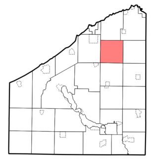
Arkwright is a town in Chautauqua County, New York, in the United States. As of the 2010 census, the town population was 1,061. The town is named after Richard Arkwright, the inventor of a spinning device.

Birkenhead Dock Branch

Birkenhead Dock Branch is a disused railway line running from the South junction of Rock Ferry, to the site of the former Bidston Dock on the Wirral Peninsula, England. The branch is approximately 4 12 miles (7.2 km) in length. Although called a branch, the line was accessible from both ends, from Bidston East junction and from Rock Ferry railway station. The former Mollington Street Rail Depot was branched into the line. A section of the line runs through Haymarket Tunnel and a low-level cutting through the centre of Birkenhead; visible from the road flyovers. The disused Canning Street North signal box and level crossing are also situated on the branch. Level crossings are also located at Duke Street and Wallasey Bridge Road. The steel railway lines are still intact never being raised.

Chesterfield Market Place railway station

Chesterfield Market Place railway station was a former railway station in the centre of the town of Chesterfield, Derbyshire, England.

Sutton cum Duckmanton

Sutton cum Duckmanton is a civil parish in Derbyshire, England, lying between Bolsover and Chesterfield but in the district of North East Derbyshire.

Adelphi Canal

The Adelphi Canal was a small privately owned canal in Duckmanton, near Chesterfield, England. It was used to transport goods from an ironworks to a wharf by the road. It is not connected to any other waterway; goods were forwarded by road to the Chesterfield Canal. It was constructed in 1799.

Arkwright Town railway station

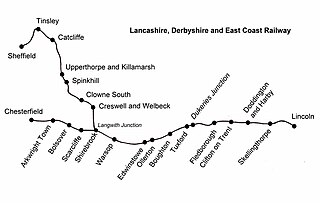
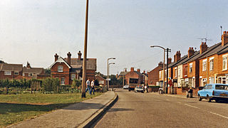
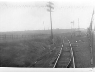
Arkwright Town railway station was in Arkwright Town, Derbyshire, England.

Ollerton railway station

Ollerton railway station is a former railway station in Ollerton, Nottinghamshire, England.

Creswell and Welbeck railway station

Creswell and Welbeck railway station used to serve the village of Creswell, in north eastern Derbyshire, England.

Bolsover Tunnel is a disused and infilled twin-track railway tunnel between Carr Vale and Scarcliffe in Derbyshire, England.

Duckmanton Tunnel

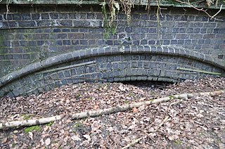
Duckmanton Tunnel is a former 501-yard (458-metre) long twin-track railway tunnel between Chesterfield and Arkwright Town in Derbyshire, England.

Duckmanton North Junction former railway junction in Derbyshire, UK

Duckmanton North Junction is a former railway junction near Arkwright Town in Derbyshire, England.

Duckmanton South Junction former railway junction in Derbyshire, UK

Duckmanton South Junction is a former railway junction near Arkwright Town in Derbyshire, England.

Duckmanton East Junction is a former railway junction near Arkwright Town in Derbyshire, England.

The Clowne Branch is a lifted but protected former railway line in north eastern Derbyshire, England. currently being developed as part of the Greenway network for walkers, cyclists and horse riders

Beighton Junction is a set of railway junctions near Beighton on the border between Derbyshire and South Yorkshire, England.

The Pudsey Loop was a railway line in West Yorkshire, England, which served the town of Pudsey and offered a second connection between Bramley and Stanningley in the east and Laisterdyke and Dudley Hill in the west, in addition to the existing line between Leeds and Bradford.

References

Coordinates: 53°13′55.42″N1°21′7.84″W / 53.2320611°N 1.3521778°W / 53.2320611; -1.3521778

Geographic coordinate system Coordinate system

A geographic coordinate system is a coordinate system that enables every location on Earth to be specified by a set of numbers, letters or symbols. The coordinates are often chosen such that one of the numbers represents a vertical position and two or three of the numbers represent a horizontal position; alternatively, a geographic position may be expressed in a combined three-dimensional Cartesian vector. A common choice of coordinates is latitude, longitude and elevation. To specify a location on a plane requires a map projection.