Arrondissement of Brioude

Last updated • 2 min readFrom Wikipedia, The Free Encyclopedia
Brioude
Locator map of Arrondissement Brioude 2019.png
Location within the region Auvergne-Rhône-Alpes
Country France
Region Auvergne-Rhône-Alpes
Department Haute-Loire
No. of  communes 111
Subprefecture Brioude
Area
1,886.8 km2 (728.5 sq mi)
Population
 (2021) [1]
44,829
  Density24/km2 (60/sq mi)
INSEE code 431

The Arrondissement of Brioude is an arrondissement of France in the Haute-Loire department in the Auvergne-Rhône-Alpes region. It has 111 communes. [2] Its population is 44,829 (2021), and its area is 1,886.8 km2 (728.5 sq mi). [3]

Contents

Composition

The communes of the arrondissement of Brioude are: [2]

  1. Agnat
  2. Ally
  3. Arlet
  4. Aubazat
  5. Autrac
  6. Auvers
  7. Auzon
  8. Azérat
  9. Beaumont
  10. Berbezit
  11. La Besseyre-Saint-Mary
  12. Blassac
  13. Blesle
  14. Bonneval
  15. Bournoncle-Saint-Pierre
  16. Brioude
  17. Cerzat
  18. La Chaise-Dieu
  19. Chambezon
  20. Champagnac-le-Vieux
  21. Chanaleilles
  22. Chaniat
  23. Chanteuges
  24. La Chapelle-Geneste
  25. Charraix
  26. Chassagnes
  27. Chassignolles
  28. Chastel
  29. Chavaniac-Lafayette
  30. Chazelles
  31. Chilhac
  32. La Chomette
  33. Cistrières
  34. Cohade
  35. Collat
  36. Connangles
  37. Couteuges
  38. Cronce
  39. Cubelles
  40. Desges
  41. Domeyrat
  42. Espalem
  43. Esplantas-Vazeilles
  44. Félines
  45. Ferrussac
  46. Fontannes
  47. Frugerès-les-Mines
  48. Frugières-le-Pin
  49. Grenier-Montgon
  50. Grèzes
  51. Javaugues
  52. Jax
  53. Josat
  54. Lamothe
  55. Langeac
  56. Laval-sur-Doulon
  57. Lavaudieu
  58. Lavoûte-Chilhac
  59. Lempdes-sur-Allagnon
  60. Léotoing
  61. Lorlanges
  62. Lubilhac
  63. Malvières
  64. Mazerat-Aurouze
  65. Mazeyrat-d'Allier
  66. Mercœur
  67. Monistrol-d'Allier
  68. Montclard
  69. Paulhac
  70. Paulhaguet
  71. Pébrac
  72. Pinols
  73. Prades
  74. Saint-Arcons-d'Allier
  75. Saint-Austremoine
  76. Saint-Beauzire
  77. Saint-Bérain
  78. Saint-Christophe-d'Allier
  79. Saint-Cirgues
  80. Saint-Didier-sur-Doulon
  81. Sainte-Eugénie-de-Villeneuve
  82. Sainte-Florine
  83. Sainte-Marguerite
  84. Saint-Étienne-sur-Blesle
  85. Saint-Georges-d'Aurac
  86. Saint-Géron
  87. Saint-Hilaire
  88. Saint-Ilpize
  89. Saint-Julien-des-Chazes
  90. Saint-Just-près-Brioude
  91. Saint-Laurent-Chabreuges
  92. Saint-Pal-de-Senouire
  93. Saint-Préjet-Armandon
  94. Saint-Préjet-d'Allier
  95. Saint-Privat-du-Dragon
  96. Saint-Vénérand
  97. Saint-Vert
  98. Salzuit
  99. Saugues
  100. Sembadel
  101. Siaugues-Sainte-Marie
  102. Tailhac
  103. Thoras
  104. Torsiac
  105. Vals-le-Chastel
  106. Venteuges
  107. Vergongheon
  108. Vézézoux
  109. Vieille-Brioude
  110. Villeneuve-d'Allier
  111. Vissac-Auteyrac

History

The arrondissement of Brioude was created in 1800. [4] In 2007 it absorbed the canton of Saugues from the arrondissement of Le Puy-en-Velay. [4]

As a result of the reorganisation of the cantons of France which came into effect in 2015, the borders of the cantons are no longer related to the borders of the arrondissements. The cantons of the arrondissement of Brioude were, as of January 2015: [5]

  1. Auzon
  2. Blesle
  3. Brioude-Nord
  4. Brioude-Sud
  5. La Chaise-Dieu
  6. Langeac
  7. Lavoûte-Chilhac
  8. Paulhaguet
  9. Pinols
  10. Saugues

Related Research Articles

<span class="mw-page-title-main">Haute-Loire</span> Department in Auvergne-Rhône-Alpes, France

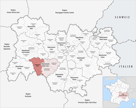
Haute-Loire is a landlocked department in the Auvergne-Rhône-Alpes region of south-central France. Named after the Loire River, it is surrounded by the departments of Loire, Ardèche, Lozère, Cantal and Puy-de-Dôme. In 2019, it had a population of 227,570; its inhabitants are called Altiligériens in French.

<span class="mw-page-title-main">Arrondissement of Lyon</span> Arrondissement in Auvergne-Rhône-Alpes, France

The arrondissement of Lyon is an arrondissement of France in the Auvergne-Rhône-Alpes region. It has 134 communes. Its population is 1,585,411 (2016), and its area is 1,534.6 km2 (592.5 sq mi).

<span class="mw-page-title-main">La Chaise-Dieu</span> Commune in Auvergne-Rhône-Alpes, France

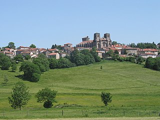
La Chaise-Dieu is a commune in the Haute-Loire department in south-central France. Its inhabitants are called Casadéens, from the Latin name of the city.

<span class="mw-page-title-main">Arrondissements of the Haute-Loire department</span>

The 3 arrondissements of the Haute-Loire department are:

  1. Arrondissement of Brioude, with 111 communes. The population of the arrondissement was 44,829 in 2021.
  2. Arrondissement of Le Puy-en-Velay, with 102 communes. The population of the arrondissement was 96,495 in 2021.
  3. Arrondissement of Yssingeaux, with 44 communes. The population of the arrondissement was 85,960 in 2021.
<span class="mw-page-title-main">Arrondissement of Nantes</span> Arrondissement in Pays de la Loire, France

The arrondissement of Nantes is an arrondissement of France in the Loire-Atlantique department in the Pays de la Loire region. It has 76 communes. Its population is 881,045 (2021), and its area is 1,958.7 km2 (756.3 sq mi).

<span class="mw-page-title-main">Arrondissement of Saint-Nazaire</span> Arrondissement in Pays de la Loire, France

The arrondissement of Saint-Nazaire is an arrondissement of France in the Loire-Atlantique department in the Pays de la Loire region. It has 55 communes. Its population is 345,185 (2021), and its area is 1,758.1 km2 (678.8 sq mi).

<span class="mw-page-title-main">Arrondissement of Muret</span> Arrondissement in Occitania, France

The arrondissement of Muret is an arrondissement of France in the Haute-Garonne department in the Occitanie region. It has 126 communes. Its population is 231,646 (2021), and its area is 1,630.9 km2 (629.7 sq mi). Its seat is in Muret.

<span class="mw-page-title-main">Arrondissement of Le Puy-en-Velay</span> Arrondissement in Auvergne-Rhône-Alpes, France

The arrondissement of Le Puy-en-Velay is an arrondissement of France in the Haute-Loire department in the Auvergne-Rhône-Alpes region. It has 102 communes. Its population is 96,495 (2021), and its area is 1,930.7 km2 (745.4 sq mi).

<span class="mw-page-title-main">Arrondissement of Yssingeaux</span> Arrondissement in Auvergne-Rhône-Alpes, France

The arrondissement of Yssingeaux is an arrondissement of France in the Haute-Loire departement in the Auvergne-Rhône-Alpes region. It has 44 communes. Its population is 85,960 (2021), and its area is 1,159.7 km2 (447.8 sq mi).

<span class="mw-page-title-main">Arrondissement of Riom</span> Arrondissement in Auvergne-Rhône-Alpes, France

The arrondissement of Riom is an arrondissement of France in the Puy-de-Dôme department in the Auvergne-Rhône-Alpes region. It has 155 communes. Its population is 135,164 (2016), and its area is 2,705.3 km2 (1,044.5 sq mi).

<span class="mw-page-title-main">Arrondissement of Mende</span> Arrondissement in Occitania, France

The arrondissement of Mende is an arrondissement of France in the Lozère department in the Occitanie région. Its INSEE code is 482 and its capital city, and prefecture of the department, is Mende. Its population is 63,491 (2021), and its area is 3,479.4 km2 (1,343.4 sq mi).

<span class="mw-page-title-main">Saugues</span> Commune in Auvergne-Rhône-Alpes, France

Saugues is a commune in the Haute-Loire department in south-central France.

<span class="mw-page-title-main">Lavoûte-Chilhac</span> Commune in Auvergne-Rhône-Alpes, France

Lavoûte-Chilhac is a commune in the Haute-Loire department in south-central France. It is a member of Les Plus Beaux Villages de France Association.

<span class="mw-page-title-main">Senouire</span> River in France

The Senouire is a 63.1-kilometre (39.2 mi) long river in the Haute-Loire département, south-central France. Its source is at Sembadel. It flows generally west. It is a right tributary of the Allier into which it flows between Fontannes and Vieille-Brioude, near Brioude.

The canton of Gorges de l'Allier-Gévaudan is an administrative division of the Haute-Loire department, south-central France. It was created at the French canton reorganisation which came into effect in March 2015. Its seat is in Langeac.

The canton of Pays de Lafayette is an administrative division of the Haute-Loire department, south-central France. It was created at the French canton reorganisation which came into effect in March 2015. Its seat is in Mazeyrat-d'Allier.

The canton of Plateau du Haut-Velay granitique is an administrative division of the Haute-Loire department, south-central France. It was created at the French canton reorganisation which came into effect in March 2015. Its seat is in Craponne-sur-Arzon.

The canton of Sainte-Florine is an administrative division of the Haute-Loire department, south-central France. It was created at the French canton reorganisation which came into effect in March 2015. Its seat is in Sainte-Florine.

Communauté d'agglomération du Puy-en-Velay is the communauté d'agglomération, an intercommunal structure, centred on the town of Le Puy-en-Velay. It is located in the Haute-Loire department, in the Auvergne-Rhône-Alpes region, south-central France. Created in 2017, its seat is in Le Puy-en-Velay. Its area is 1324.0 km2. Its population was 82,871 in 2019, of which 19,215 in Le Puy-en-Velay proper.

References

  1. "Téléchargement du fichier d'ensemble des populations légales en 2021" (in French). The National Institute of Statistics and Economic Studies. 28 December 2023.
  2. 1 2 "Arrondissement de Brioude (431)". INSEE . Retrieved 10 December 2024.
  3. "Comparateur de territoire, géographie au 01/01/2023". INSEE . Retrieved 10 December 2024.
  4. 1 2 Historique de la Haute-Loire
  5. "Populations légales 2012: 43 Haute-Loire" (PDF). INSEE. December 2014.

45°17′40″N3°23′06″E / 45.29444°N 3.38500°E / 45.29444; 3.38500