Related Research Articles

Arunachal Pradesh is a state in Northeastern India. It was formed from the erstwhile North-East Frontier Agency (NEFA) region, and became a state on 20 February 1987. It borders the states of Assam and Nagaland to the south. It shares international borders with Bhutan in the west, Myanmar in the east, and a disputed border with China in the north at the McMahon Line. Itanagar is the state capital of Arunachal Pradesh. Arunachal Pradesh is the largest of the Seven Sister States of Northeast India by area. Arunachal Pradesh shares a 1,129 km border with China's Tibet Autonomous Region.

Ziro is a town and the district headquarters of the Lower Subansiri district in the Indian state of Arunachal Pradesh. It is included the Tentative List for UNESCO's World Heritage Site for the Apatani cultural landscape. The part of the town which is the centre of economic activities and where the administrative offices are located is called as Hapoli or locally known by the Apatanis as "Hao-Polyang".

Itanagar is the capital and largest town of the Indian state of Arunachal Pradesh. The seat of Arunachal Pradesh Legislative Assembly, the seat of government of Arunachal Pradesh, and the seat of Gauhati High Court permanent bench at Naharlagun are all in Itanagar. Being the hub of all the major economic bases, Itanagar along with the adjacent town of Naharlagun comprising the administrative region of Itanagar Capital Complex Region stretching from the Itanagar Municipal limit at Chandranagar Town extended till Nirjuli Town, is a major junction of Cultural, economic, fashion, education and recreational activities.
Seppa is the headquarters of the East Kameng district in the state of Arunachal Pradesh in India. Sapla means 'marshy' land in the local dialect. It lies on the bank of Kameng River and there is a helipad there. It is located 160 kilometres (99 mi) from Itanagar and 213 kilometres (132 mi) from Tezpur (Assam) connected by motorable road. The village of Seppa has two out of the sixty Vidhan Sabha Constituencies of Arunachal Pradesh. They are Seppa East and Seppa West.

Pasighat is the headquarters of East Siang district in the Indian state of Arunachal Pradesh. Situated at the eastern foothills of the Himalayas at 155 meters (509 ft) above mean sea level, Pasighat is Arunachal's oldest town. The Government of India included Pasighat in the Smart Cities Mission development scheme in June 2017.
Tezu is a census town and the headquarters of Lohit district in the Indian state of Arunachal Pradesh. It is the fifth largest town in Arunachal Pradesh and one of its most developed.

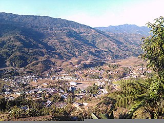
Yingkiong is a town in and the administrative headquarters of Upper Siang district in the Northeast Indian state of Arunachal Pradesh. It is located 250 kilometres (160 mi) north of Itanagar, the capital of the state, and 1 kilometre (0.62 mi) east of the River Siang. According to the 2011 Census, the town has a total population of 8,573.

Aalo, formerly Along, is a census town and headquarter of the West Siang district district of the Indian state of Arunachal Pradesh. It is located 137 kilometres (85 mi) from Likabali, which is at the border of Assam and Arunachal Pradesh.

Amalapuram is a town in the Indian state of Andhra Pradesh. It is the district headquarters and the largest town of Konaseema district. It is the mandal and divisional headquarters of Amalapuram mandal and Amalapuram revenue division respectively. The town is situated in the delta of konaseema.

Pasighat Airport is a regional airport serving Pasighat, Arunachal Pradesh, India.
Andhra Pradesh State Road Transport Corporation (APSRTC) is the state-owned road transport corporation in the Indian state of Andhra Pradesh. Its headquarters is located at NTR Administrative Block of RTC House in Pandit Nehru bus station of Vijayawada. Many other Indian metro towns in Telangana, Tamil Nadu, Karnataka, Odisha, Yanam, Kerala, Maharashtra and Chhattisgarh are also linked with the APSRTC services.
The Ministry of Development of North Eastern Region is a Government of India ministry, established in September 2001, which functions as the nodal Department of the Central Government to deal with matters related to the socio-economic development of the eight States of Northeast India: Arunachal Pradesh, Assam, Manipur, Meghalaya, Mizoram, Nagaland, Tripura and Sikkim. It acts as a facilitator between the Central Ministries/ Departments and the State Governments of the North Eastern Region in the economic development including removal of infrastructural bottlenecks, provision of basic minimum services, creating an environment for private investment and to remove impediments to lasting peace and security in the North Eastern Region.
Pakke Tiger Reserve, also known as Pakhui Tiger Reserve, is a Project Tiger reserve in the Pakke Kessang district of Arunachal Pradesh in northeastern India. The 862 km2 (333 sq mi) reserve is protected by the Department of Environment and Forest of Arunachal Pradesh. In a notification (CWL/D/26/94/1393-1492) dated Itanagar 19 April 2001, issued by the Principal Secretary, the Governor of Arunachal Pradesh renamed Pakhui Wildlife Sanctuary as Pakke Wildlife Sanctuary Division.

Papum Pare district is an administrative district in the state of Arunachal Pradesh in India. As of 2011, it is the most populous district of Arunachal Pradesh.
Koloriang is a hilly district headquarters town of Kurung Kumey district in Arunachal Pradesh, India, bordering Tibet. It has an altitude of 1,000 metres (3,300 ft) and is surrounded by high mountains all around and is located in the right bank of river Kurung, one of the major tributaries of Subansiri river. The climate is rainy and hot during summer and very cold in winter. Located at an altitude of 1,040 metres above sea level, this town is also an old administrative centre. It is about 257 km from state capital, Itanagar.
Palin is a hill station and the headquarter of Kra Daadi district in Arunachal Pradesh. It is inhabited by Nyishi tribe of Arunachal Pradesh and has a population of 5816 according to the 2001 census. The incumbent MLA from Palin constituency is Balo Raja.
Andhra Pradesh is well connected with various destinations in India, as well as other countries. It has road, rail, airways. With a long coast of Bay of Bengal and many sea ports, it flourishes in sea trade as well. The state has one of the largest railway junctions at Vijayawada and Visakhapatnam Port being one of the largest cargo handling seaport.

Mayodia Pass is located about 56 km from Roing in Arunachal Pradesh, with an elevation of 2,655 m above sea level. "Mayodia" is combination of two Idu-Mishmi words - "Mayu" which is the name of the mountain and "Dia" meaning "peak of the mountain", thereby meaning "Peak of the Mayu Mountain". It is a frequent domestic tourist attraction for the snow fall it receives during winters. Nearest town is Roing (56 km).
Kamle district, also Khamle, is one of the 25 administrative districts of Arunachal Pradesh in northeastern India. The district headquarters are at Raga.

Shi Yomi district is one of the 23 districts of Arunachal Pradesh state in northeastern India. Shi-Yomi district was created on 9 December 2018 by dividing the West Siang district when northern areas along the China border were made into a newly created Shi-Yomi district and the remaining southern areas remain the part truncated West Siang district. It has its headquarters at Tato.
References
- ↑ "Introduction". Archived from the original on 20 December 2016. Retrieved 3 January 2017.
- ↑ "BusSchedule". Archived from the original on 21 November 2016. Retrieved 3 January 2017.
- ↑ "Transport". Archived from the original on 17 December 2016. Retrieved 3 January 2017.
- ↑ Itanagar-Dimapur bus service flagged off
- ↑ "Night coach bus services introduced". Archived from the original on 3 January 2017. Retrieved 3 January 2017.
- ↑ PSTS:
| | This article about transport in India is a stub. You can help Wikipedia by expanding it. |