Ashburnham, East Sussex

Last updated

Ashburnham
St Peter's Church, Ashburnham (Geograph Image 2280261 84d8424e).jpg
St Peter's Church, Ashburnham
East Sussex UK location map.svg
Red pog.svg
Ashburnham
Location within East Sussex
Population303 (2001 Census)
  Density 43/sq mi (17/km2)
OS grid reference TQ666179
  London 44 miles (71 km) NNW
Civil parish
  • Ashburnham
District
Shire county
Region
Country England
Sovereign state United Kingdom
Post town BATTLE
Postcode district TN33
Dialling code 01424
Police Sussex
Fire East Sussex
Ambulance South East Coast
UK Parliament
List of places
UK
England
East Sussex
50°55′N0°23′E / 50.91°N 0.38°E / 50.91; 0.38 Coordinates: 50°55′N0°23′E / 50.91°N 0.38°E / 50.91; 0.38

Ashburnham is a civil parish in the Rother district of East Sussex, England, situated to the west of Battle. It includes the settlements of Brownbread Street and Ponts Green; Ashburnham Forge is also within the parish. [1] Ashburnham shares a parish council with the neighbouring small parish of Penhurst.

Contents

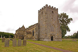
Ashburnham takes its name from Ashburnham Place, now a Christian conference and prayer centre, which in turn comes from the fact that the local stream is the Ashbourne. The 14th century parish church, dedicated to St Peter, was rebuilt in 1665. The village was in the iron making district of the Weald, and its blast furnace was the last in Sussex to be closed in 1813.

Ashburnham and neighbouring Penhurst, neither of which have many dwellings, were united in 1810.

The parish has a population of 303 (2001 census).

Landscape

Ashburnham is located in the heart of the Sussex Weald within the designated High Weald Area of Outstanding Natural Beauty.

Landmarks

Ashburnham Park falls within the area and is a Site of Special Scientific Interest. It comprises 100.7 hectares (249 acres) ancient woodland and medieval deer park, containing a wide spread of flora and avian fauna. [2] In 1767 the 2nd Earl of Ashburnham commissioned Lancelot ("Capability") Brown to remodel the park which he did by including three large lakes. Part of the park lies in the neighbouring Catsfield parish.

Several features of the old iron industry can be found along the track from the hamlet of Ashburnham Forge up to the furnace site near Lakehurst Lane. [3]

Governance

At a local level, Ashburnham and neighbouring Penhurst have been governed by a joint parish council, The Parish Council of Ashburnham with Penhurst, since a Grouping Order was made in 1954. [4] The parish council is made up of seven councillors, split into two wards: five councillors from Ashburnham ward and two from Penhurst ward. [5] The May 2019 election had four candidates standing in the Ashburnham ward who were returned unopposed. [6] The Penhurst ward was uncontested. Since then one councillor was co-opted to fill the remaining vacancy in the Ashburnham ward.

Rother District Council provides the next level of government. Ashburnham and Penhurst are within the Crowhurst ward, along with the parishes of Catsfield, Crowhurst, and part of Battle. In the May 2007 election Crowhurst ward was won by the Conservative candidate. [7]

East Sussex County Council is the top tier of local government. Ashburnham with Penhurst falls within the Battle and Crowhurst ward. Kathryn Margaret Field, Liberal Democrat, was elected in the May 2005 election with 48.8% of the vote. [8]

The UK Parliament constituency for Ashburnham and Penhurst is Bexhill and Battle.

Prior to Brexit in 2020, the villages were part of the South East England constituency in the European Parliament.

Related Research Articles

Wealden District Non-metropolitan district in England

Wealden is a local government district in East Sussex, England. Its council is based in Hailsham. The district's name comes from the Weald, the remnant forest which was once unbroken and occupies much of the centre and north of the area.

Chichester District Non-metropolitan district in England

Chichester is a local government district in West Sussex, England. Its council is based in the city of Chichester and the district also covers a large rural area to the north.

Polegate Human settlement in England

Polegate is a town and civil parish in the Wealden District of East Sussex, England, United Kingdom. It is located five miles (8 km) north of the seaside resort of Eastbourne and is part of the greater area of that town. Although once a railway settlement, its rail links were closed as part of the Beeching cuts. The 2011 census put the civil parish of Polegate at a population of 8,586, with 41.2% aged 65 and over.

Battle, East Sussex Town and civil parish in the local government district of Rother in East Sussex, England

Battle is a small town and civil parish in the local government district of Rother in East Sussex, England. It lies 50 miles (80 km) south-east of London, 30 miles (50 km) east of Brighton and 20 miles (30 km) east of Lewes. Hastings is to the south-east and Bexhill-on-Sea to the south. Battle is in the designated High Weald Area of Outstanding Natural Beauty, and is a tourist destination and commuter town for white collar workers in the City of London. The parish population was 6,048 according to the 2001 census, increasing to 6,673 with the 2011 Census.

Burwash Human settlement in England

Burwash, archaically known as Burghersh, is a rural village and civil parish in the Rother district of East Sussex, England. Situated in the High Weald of Sussex some 15 miles (24 km) inland from the port of Hastings, it is located five miles (8 km) south-west of Hurst Green, on the A265 road, and on the River Dudwell, a tributary of the River Rother. In an area steeped in history, some nine miles (14 km) to the south-east lies Battle Abbey and eight miles (13 km) to the east is Bodiam Castle.

Bexhill and Battle (UK Parliament constituency) UK Parliament constituency in England since 1983

Bexhill and Battle is a constituency represented in the House of Commons of the UK Parliament since 2015 by Huw Merriman of the Conservative Party.

Buxted Village in Sussex, England

Buxted is a village and civil parish in the Wealden District of East Sussex in England. The parish is situated on the Weald, north of Uckfield; the settlements of Five Ash Down, Heron's Ghyll and High Hurstwood are included within its boundaries. At one time its importance lay in the Wealden iron industry, and later it became commercially important in the poultry and egg industry.

Peasmarsh Human settlement in England

Peasmarsh is a village and civil parish in the Rother district, in the county of East Sussex in England. It is located on the A268 road between Rye and Beckley, some 3 miles (4.8 km) north-west of Rye.

Crowhurst, East Sussex Human settlement in England

Crowhurst is an isolated village situated five miles (8 km) north-west of Hastings in East Sussex. It has a parish council and is located within the Rother District Council.

Beckley, East Sussex Human settlement in England

Beckley is a village and civil parish in the Rother district of East Sussex, England. It is located on the B2088 minor road above the Rother Levels five miles (8 km) northwest of Rye and ten miles (16 km) from Hastings. The northern border follows the river Rother.

Mountfield, East Sussex Human settlement in England

Mountfield is a village and civil parish in the Rother district of East Sussex, England, and three miles (5 km) north-west of Battle. It is mentioned in the Domesday Book.

Brightling Human settlement in England

Brightling is a village and civil parish in the Rother district of East Sussex, England. It is located on the Weald eight miles (13 km) north-west of Battle and four miles (6 km) west of Robertsbridge.

Catsfield Human settlement in England

Catsfield is a village and civil parish in the Rother district of East Sussex, England. It is located six miles (9.7 km) north of Bexhill, and three miles (5 km) southwest of Battle.

Dallington, East Sussex Human settlement in England

Dallington is a village and civil parish in the Rother district of East Sussex, England. It is located eight miles (13 km) west of Battle and five miles (8 km) east of Heathfield.

Penhurst Human settlement in England

Penhurst is a village and civil parish, sharing a parish council with neighbouring Ashburnham, in the Rother district of East Sussex, England. It is located on the Weald, 4 miles (7km) west of Battle.

Whatlington Human settlement in England

Whatlington is a village and civil parish in the Rother district of East Sussex, England. The village is located seven miles (11 km) north of Hastings, just off the A21 road.

Rother District Council Administrative area of East Sussex, UK

The Rother District Council is elected every four years, with currently 38 councillors being elected at each election. From 1983 until 2019, the Conservatives have had a majority on the council, apart from between 1991 and the 1999 election when no party had a majority. Since 2019, the 'Rother Alliance' has controlled the council, formed of a mixture of Independent, Liberal Democrat, Labour and Green Party councillors. As of the last election in 2019 the council was composed of the following councillors:-

The 1999 Rother District Council election took place on 6 May 1999 to elect members of Rother District Council in East Sussex, England. The whole council was up for election and the Conservative party gained overall control of the council from no overall control.

2007 Rother District Council election Local municipal election

The 2007 Rother District Council election took place on 3 May 2007 to elect members of Rother District Council in East Sussex, England. The whole council was up for election and the Conservative Party stayed in overall control of the council.

References

  1. "Election Maps". Ordnance Survey . Retrieved 11 June 2022.
  2. "SSSI Citation Ashburnham Park" (PDF). Natural England. Retrieved 25 May 2008.{{cite journal}}: Cite journal requires |journal= (help)
  3. Pearce, H, Hammer and Furnace Ponds, Pomegranate Press, 2011
  4. "Your Parish Council". Parish Council of Ashburnham with Penhurst. Retrieved 11 June 2022.
  5. "Notice of Election" (PDF). Rother District Council. 5 May 2005. Archived from the original (PDF) on 25 February 2009. Retrieved 27 November 2008.
  6. "Election and Referendum Results". Rother District Council. Retrieved 1 January 2021.
  7. "Declaration of Result of PollCrowhurst". Rother District Council. 5 May 2005. Retrieved 24 November 2008.
  8. "County Council election". Rother District Council. 5 May 2005. Archived from the original on 20 November 2008. Retrieved 19 November 2008.