
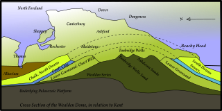
The Weald is an area of South East England between the parallel chalk escarpments of the North and the South Downs. It crosses the counties of Hampshire, Surrey, West Sussex, East Sussex, and Kent. It has three parts, the sandstone "High Weald" in the centre, the clay "Low Weald" periphery and the Greensand Ridge, which stretches around the north and west of the Weald and includes its highest points. The Weald once was covered with forest and its name, Old English in origin, signifies "woodland". The term is still used, as scattered farms and villages sometimes refer to the Weald in their names.

Dorset is a county in South West England on the English Channel coast. Covering an area of 2,653 square kilometres (1,024 sq mi); it borders Devon to the west, Somerset to the north-west, Wiltshire to the north-east, and Hampshire to the east. The great variation in its landscape owes much to the underlying geology, which includes an almost unbroken sequence of rocks from 200 to 40 million years ago (Mya) and superficial deposits from 2 Mya to the present. In general, the oldest rocks appear in the far west of the county, with the most recent (Eocene) in the far east. Jurassic rocks also underlie the Blackmore Vale and comprise much of the coastal cliff in the west and south of the county; although younger Cretaceous rocks crown some of the highpoints in the west, they are mainly to be found in the centre and east of the county.

Weald Clay or the Weald Clay Formation is a Lower Cretaceous sedimentary rock unit underlying areas of South East England, between the North and South Downs, in an area called the Weald Basin. It is the uppermost unit of the Wealden Group of rocks within the Weald Basin, and the upper portion of the unit is equivalent in age to the exposed portion of the Wessex Formation on the Isle of Wight. It predominantly consists of thinly bedded mudstone. The un-weathered form is blue/grey, and the yellow/orange is the weathered form, it is used in brickmaking.

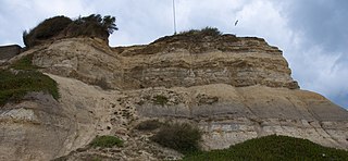
Fairlight is a village in East Sussex, England within Rother district, three miles (5 km) to the east of Hastings. Fairlight is also the name of the civil parish forming part of the Rother district which includes the villages of Fairlight and the much larger Fairlight Cove. The village of Fairlight lies on a minor road between Ore, Pett and Winchelsea.

The Purbeck Group is an Upper Jurassic to Lower Cretaceous lithostratigraphic group in south-east England. The name is derived from the district known as the Isle of Purbeck in Dorset where the strata are exposed in the cliffs west of Swanage.

Pett is a village and civil parish in the Rother district of East Sussex, England. The village is located 5 miles (8.0 km) north-east of Hastings on the edge of Pett Level, the one-time marshes stretching along the coast of Rye Bay.
The Wealden Group, occasionally also referred to as the Wealden Supergroup, is a group in the lithostratigraphy of southern England. The Wealden group consists of paralic to continental (freshwater) facies sedimentary rocks of Berriasian to Aptian age and thus forms part of the English Lower Cretaceous. It is composed of alternating sands and clays. The sandy units were deposited in a flood plain of braided rivers, the clays mostly in a lagoonal coastal plain.
The Vale of Kent, located in Kent, England, is the name given to the broad clay vale between the Greensand Ridge and the High Weald. The area is drained by a number of rivers, including the Beult, Eden, Medway, Stour and River Teise.

The Greensand Ridge, also known as the Wealden Greensand, is an extensive, prominent, often wooded, mixed greensand/sandstone escarpment in south-east England. Forming part of the Weald, a former dense forest in Sussex, Surrey and Kent, it runs to and from the East Sussex coast, wrapping around the High Weald and Low Weald. It reaches its highest elevation, 294 metres (965 ft), at Leith Hill in Surrey—the second highest point in south-east England, while another hill in its range, Blackdown, is the highest point in Sussex at 280 metres (919 ft). The eastern end of the ridge forms the northern boundary of Romney Marsh.
Kent is the south-easternmost county in England. It is bounded on the north by the River Thames and the North Sea, and on the south by the Straits of Dover and the English Channel. The continent of Europe is 21 miles across the straits.

Sussex is a historic county and cultural region in the south of England corresponding roughly in area to the ancient Kingdom of Sussex. It is bounded on the north by Surrey, north-east by Kent, south by the English Channel, and west by Hampshire, and is divided for local government into West Sussex and East Sussex and the city of Brighton and Hove. The city of Brighton & Hove was created a unitary authority in 1997, and was granted City status in 2000. Until then Chichester had been Sussex's only city. By convention, Chichester is Sussex's capital city and Lewes is Sussex's county town.

The Lower Greensand Group is a geological unit present across large areas of Southern England. It was deposited during the Aptian and Albian stages of the Early Cretaceous. It predominantly consists of sandstone and unconsolidated sand that were deposited in shallow marine conditions.

The geology of East Sussex is defined by the Weald–Artois anticline, a 60 kilometres (37 mi) wide and 100 kilometres (62 mi) long fold within which caused the arching up of the chalk into a broad dome within the middle Miocene, which has subsequently been eroded to reveal a lower Cretaceous to Upper Jurassic stratigraphy. East Sussex is best known geologically for the identification of the first dinosaur by Gideon Mantell, near Cuckfield, to the famous hoax of the Piltdown man near Uckfield.

The Tunbridge Wells Sand Formation is a geological unit which forms part of the Wealden Group and the uppermost and youngest part of the unofficial Hastings Beds. These geological units make up the core of the geology of the Weald in the English counties of West Sussex, East Sussex and Kent.

The Wadhurst Clay Formation is a geological unit which forms part of the Wealden Group and the middle part of the now unofficial Hastings Beds. These geological units make up the core of the geology of the High Weald in the English counties of West Sussex, East Sussex and Kent.

The geology of the Isle of Wight is dominated by sedimentary rocks of Cretaceous and Paleogene age. This sequence was affected by the late stages of the Alpine Orogeny, forming the Isle of Wight monocline, the cause of the steeply-dipping outcrops of the Chalk Group and overlying Paleogene strata seen at The Needles, Alum Bay and Whitecliff Bay.
The geology of Kent in southeast England largely consists of a succession of northward dipping late Mesozoic and Cenozoic sedimentary rocks overlain by a suite of unconsolidated deposits of more recent origin.

Southern Sandstone is a local name for the Ardingly Sandstone of southeast England, a soft sandstone of Cretaceous age separating the Tunbridge Wells Sands from the overlying Grinstead Clay. The outcrops in the Weald of Kent are the rock climbing crags closest to London and are probably the most heavily climbed in the UK.
The geology of West Sussex in southeast England comprises a succession of sedimentary rocks of Cretaceous age overlain in the south by sediments of Palaeogene age. The sequence of strata from both periods consists of a variety of sandstones, mudstones, siltstones and limestones. These sediments were deposited within the Hampshire and Weald basins. Erosion subsequent to large scale but gentle folding associated with the Alpine Orogeny has resulted in the present outcrop pattern across the county, dominated by the north facing chalk scarp of the South Downs. The bedrock is overlain by a suite of Quaternary deposits of varied origin. Parts of both the bedrock and these superficial deposits have been worked for a variety of minerals for use in construction, industry and agriculture.
The geology of the South Downs National Park in South East England comprises a gently folded succession of sedimentary rocks from the Cretaceous and early Palaeogene periods overlain in places by a range of superficial deposits from the last 2.6 million years. Whereas the South Downs are formed from the Late Cretaceous age chalk, the South Downs National Park extends into the Weald to the north of the range and thereby includes older rock strata dating from the Early Cretaceous including sandstones and mudstones. The youngest solid rocks are found on the southern fringes of the National Park in the eastern extension of the Hampshire Basin and include sand, silt and clay deposited during the Palaeocene and Eocene epochs.


