
The San Luis Valley is a region in south-central Colorado with a small portion overlapping into New Mexico. The valley is approximately 122 miles (196 km) long and 74 miles (119 km) wide, extending from the Continental Divide on the northwest rim into New Mexico on the south. It contains 6 counties and portions of 3 others. It is an extensive high-altitude depositional basin of approximately 8,000 square miles (21,000 km2) with an average elevation of 7,664 feet (2,336 m) above sea level. The valley is a section of the Rio Grande Rift and is drained to the south by the Rio Grande, which rises in the San Juan Mountains to the west of the valley and flows south into New Mexico. The San Luis Valley has a cold desert climate but has substantial water resources from the Rio Grande and groundwater.

The Apennines or Apennine Mountains are a mountain range consisting of parallel smaller chains extending c. 1,200 km (750 mi) along the length of peninsular Italy. In the northwest they join with the Ligurian Alps at Altare. In the southwest they end at Reggio di Calabria, the coastal city at the tip of the peninsula. Since 2000 the Environment Ministry of Italy, following the recommendations of the Apennines Park of Europe Project, has been defining the Apennines System to include the mountains of north Sicily, for a total distance of 1,500 kilometres (930 mi). The system forms an arc enclosing the east side of the Ligurian and Tyrrhenian Seas.

The Matterhorn is a mountain of the Alps, straddling the main watershed and border between Switzerland and Italy. It is a large, near-symmetric pyramidal peak in the extended Monte Rosa area of the Pennine Alps, whose summit is 4,478 metres (14,692 ft) high, making it one of the highest summits in the Alps and Europe. The four steep faces, rising above the surrounding glaciers, face the four compass points and are split by the Hörnli, Furggen, Leone/Lion, and Zmutt ridges. The mountain overlooks the Swiss town of Zermatt, in the canton of Valais, to the north-east and the Italian town of Breuil-Cervinia in the Aosta Valley to the south. Just east of the Matterhorn is Theodul Pass, the main passage between the two valleys on its north and south sides, which has been a trade route since the Roman Era.

The Dufourspitze is the highest peak of Monte Rosa, an ice-covered mountain massif in the Alps. Dufourspitze is the highest mountain peak of both Switzerland and the Pennine Alps and is also the second-highest mountain of the Alps and Western Europe, after Mont Blanc. It is located between Switzerland and Italy. The peak itself is located wholly in Switzerland.

Monte Rosa is a mountain massif in the eastern part of the Pennine Alps. It is between Italy's and Switzerland's (Valais). Monte Rosa is the second highest mountain in the Alps and western Europe, after Mont Blanc.

The Battle of Monte Castello was an engagement that took place from 25 November 1944 to 21 February 1945 during the Italian campaign of World War II. It was fought between the Allied forces advancing into northern Italy and the dug-in German defenders. The battle marked the Brazilian Expeditionary Force's entry into the land war in Europe. Starting in November 1944, fierce combat dragged on for three months, ending on 21 February 1945. Six Allied attacks were mounted against the German forces, four of which were tactical failures.

The Susa Valley is a valley in the Metropolitan City of Turin, Piedmont region of northern Italy, located between the Graian Alps in the north and the Cottian Alps in the south. It is one of the longest valleys of the Italian Alps. It extends over 50 kilometres (31 mi) in an east-west direction from the French border to the outskirts of Turin. The valley takes its name from the city of Susa which lies in the valley. The Dora Riparia river, a tributary of the Po, flows through the valley.

Monte Civetta is a prominent and major mountain of the Dolomites, in the Province of Belluno in northern Italy. Its north-west face can be viewed from the Taibon Agordino valley, and is classed as one of the symbols of the Dolomites.

Castel del Monte is a medieval and Renaissance hill town and comune in the province of L'Aquila in northern Abruzzo, Italy. Located in the heart of the Gran Sasso mountain range, the town is set into a steep hillside nestled beneath mountain peaks near the high plain of Campo Imperatore. Castel del Monte sits opposite the ancient mountaintop fortress of Rocca Calascio and faces Monte Sirente in the distance. It is located in the Gran Sasso e Monti della Laga National Park.

Monte Binga is the highest mountain in Mozambique and the second highest mountain in Zimbabwe. It is located in the Chimanimani Mountains, on the border between Zimbabwe and Mozambique in the Chimanimani Transfrontier Park in Manica Province. Its height is 8004 feet (2440m) above sea level.

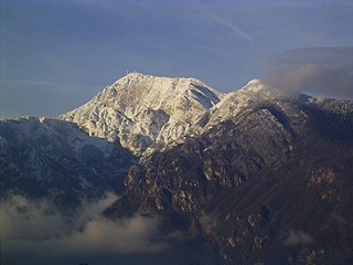
Monte Leone is the highest mountain of the Lepontine Alps and is located on the border between Switzerland and Italy. The mountain stands on the extreme west of the Lepontine Alps, a few kilometres east of Simplon Pass.
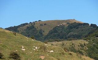
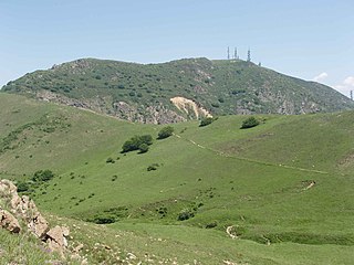
Monte Buio is a mountain in Liguria, northern Italy, part of the Ligurian Apennines. It is located between the provinces of Genoa and Alessandria. It lies at an altitude of 1400 metres.

Monte delle Figne is a mountain in Liguria, northern Italy, part of the Ligurian Apennines. It lies at an altitude of 1172 metres.
Monte Leco is a mountain in Liguria, northern Italy, part of the Ligurian Apennines. It is located in the provinces of Genoa and Alessandria. It lies at an altitude of 1072 metres.

Monte Taccone is a mountain located between Liguria and Piedmont in north-western Italy. It is part of the Ligurian Apennines.

Cinque Torri comprise a small rock formation belonging to Nuvolao group in the Dolomiti Ampezzane north-west of San Vito di Cadore and south-west of Cortina d'Ampezzo.

Montes Apenninus are a rugged mountain range on the northern part of the Moon's near side. They are named after the Apennine Mountains in Italy. With their formation dating back about 3.9 billion years, Montes Apenninus are fairly old.
Monte Bondone is a mountain of Trentino, northern Italy, located west of the provincial capital of Trento. It has an elevation of 2,180 metres (7,152 ft) and includes a ski resort on one side. It is the highest mountain of the Garda Prealps and with a prominence of 1,685 metres (5,528 ft) qualifies as an Ultra. It lies between the Etschtal valley in the east and the Sarca valley in the west. Due to its location high above the city, it is often called the mountain of Trento.

Pizzo Diei is a mountain of the Lepontine Alps in Piedmont, northern Italy. It is located in the Alpe Veglia Nature Park in the commune of Varzo, and has a slightly lower sister peak, the pyramidal shaped Monte Cistella. The mountain is a popular ski mountaineering peak and its summit offers fine views of the Monte Rosa Massif.

Rocca Barbena is a 1,142-metre (3,747 ft) high mountain in the Ligurian Prealps in Italy.

