India is the second most populated country in the world with nearly a fifth of the world's population. According to the 2019 revision of the World Population Prospects the population stood at 1,352,642,280.
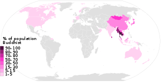
This list of Buddhism by country shows the distribution of the Buddhist religion, practiced by about 500 million people as of the 2010s, representing 7% to 8% of the world's total population.

Hinduism has approximately 1.2 billion adherents worldwide. Nepal (81.3%) and India (79.8%) are countries with Hindus being the majority of their respective populations. Along with Christianity (31.5%) and Islam (23.2%), Hinduism is one of the three major religions of the world by percentage of population. Hinduism is the third largest religion in the world after Christianity and Islam.

Chandrapur district is a district in the Nagpur Division in the Indian state of Maharashtra. Chandrapur was the largest district in India until the Gadchiroli and Sironcha tehsils were split into separate districts in 1981. In 2011, the district population was 2,204,307.
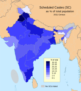
The Scheduled Caste (SCs) and Scheduled Tribes (STs) are officially designated groups of people in India. The terms are recognised in the Constitution of India and the groups are designated in one or other of the categories. For much of the period of British rule in the Indian subcontinent, they were known as the Depressed Classes.

Aurangabad district is one of the thirty-eight districts of Bihar state, India. It is currently a part of the Red Corridor.

Bulandshahr district is a district in the Meerut region in the North India state of Uttar Pradesh located between 28.4° and 28.0° north latitudes and between 77.0° and 78.0° east longitudes. Bulandshahr is the district headquarters. It is part of National Capital Region of India. Bulandshahar district is surrounded by Aligarh district, Sambhal district, Gautam buddha nagar district, Hapur district and Amroha district.
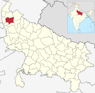
Meerut district, is one of the districts of Uttar Pradesh state of India, and Meerut is the district headquarters. Meerut district is also a part of the Meerut division. The administrative head of district of Meerut is a District Magistrate while the administrative head of Meerut Division is Divisional Commissioner, an IAS officer.

Sagardighi is a community development block that forms an administrative division in Jangipur subdivision of Murshidabad district in the Indian state of West Bengal.
Jalangi is a community development block that forms an administrative division in Domkol subdivision of Murshidabad district in the Indian state of West Bengal.
Bhagawangola I is a community development block that forms an administrative division in Lalbag subdivision of Murshidabad district in the Indian state of West Bengal.
Nabagram is a community development block that forms an administrative division in Lalbag subdivision of Murshidabad district in the Indian state of West Bengal.
Beldanga I is a community development block that forms an administrative division in Barhampur subdivision of Murshidabad district in the Indian state of West Bengal.
Hariharpara is a community development block that forms an administrative division in Barhampur subdivision of Murshidabad district in the Indian state of West Bengal.
Naoda is a community development block that forms an administrative division in Barhampur subdivision of Murshidabad district in the Indian state of West Bengal.
Domkal is a community development block that forms an administrative division in Domkal subdivision of Murshidabad district in the Indian state of West Bengal.
Suti II is a community development block that forms an administrative division in Jangipur subdivision of Murshidabad district in the Indian state of West Bengal. Aurangabad is the census town of Suti II block.
Lalgola is a community development block that forms an administrative division in Lalbag subdivision of Murshidabad district in the Indian state of West Bengal.