Lekhani is a Village Development Committee in Baglung District in the Dhaulagiri Zone of central Nepal. At the time of the 1991 Nepal census it had a population of 2,431 and had 507 houses in the village.
Deulek is a village development committee in Baitadi District in the Mahakali Zone of western Nepal. At the time of the 1991 Nepal census it had a population of 2,004 and had 354 houses in the village.
Kotila is a village development committee in Baitadi District in the Mahakali Zone of western Nepal. At the time of the 1991 Nepal census it had a population of 2,713 and had 472 houses in the town.
Kalleri is a village development committee in Dhading District in the Bagmati Zone of central Nepal. At the time of the 1991 Nepal census it had a population of 7848 and had 1433 houses in it.
Bhairabnath is a village in Bajhang District in the Seti Zone of north-western Nepal. At the time of the 1991 Nepal census it had a population of 3,275 and had 613 houses in the village.
Chyangli is a village development committee in Gorkha District in the Gandaki Zone of northern-central Nepal. At the time of the 1991 Nepal census it had a population of 5,612 and had 1066 houses in the town.
Deurali is a Village Development Committee in Gorkha District in the Gandaki Zone of northern-central Nepal. At the time of the 1991 Nepal census it had a population of 4,800 and had 984 houses in the town.
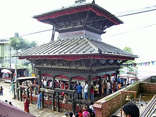
Manakamana is a village development committee in Gorkha District in the Gandaki Zone of northern-central Nepal. At the time of the 1991 Nepal census it had a population of 5,083 and had 889 houses in the town.

Ranishwara is a village development committee in Gorkha District in Gandaki Province of northern-central Nepal. At the time of the 1991 Nepal census it had a population of 2,993 and had 580 houses in the town.
Mukhiyapatti Musharniya is a village development committee in Dhanusa District in Province No. 2 of south-eastern Nepal. At the time of the 1991 Nepal census it had a population of 4,621 people living in 436 individual households.
Bolde Phediche is a village development committee in Kabhrepalanchok District in Bagmati Province of central Nepal. At the time of the 1991 Nepal census it had a population of 2324 and had 418 houses in it.
Malpi is a village development committee in Kabhrepalanchok District in the Bagmati Zone of central Nepal. At the time of the 1991 Nepal census it had a population of 3033 in 571 individual households.
Pangu, Nepal is a village in Khahare Pangu VDC, Kabhrepalanchok District in the Bagmati Zone of central Nepal. At the time of the 1991 Nepal census it had a population of 2845 in 480 individual households.
Sunthan is one of the beautiful and finest villages in Kavrepalanchowk District which lays low to house Namobuddha Gumba on its eastern side.
Thulo Lumpek is a town and municipality in Gulmi District in the Lumbini Zone of central Nepal. At the time of the 1991 Nepal census it had a population of 6175 persons living in 1020 individual households.
Parsa is a village development committee in Rupandehi District in Lumbini Province of southern Nepal. At the time of the 1991 Nepal census it had a population of 3380 people living in 507 individual households.
Nagardaha is a village development committee in Parsa District in the Narayani Zone of southern Nepal. At the time of the 2011 Nepal census it had a population of 3,583 people living in 485 individual households.
Ajingara is a village development committee in Kapilvastu District in the Lumbini Zone of southern Nepal. At the time of the 1991 Nepal census it had a population of 3646 people living in 603 individual households.
Bakamalang is a village development committee in Palpa District in the Lumbini Zone of southern Nepal. At the time of the 1991 Nepal census it had a population of 2861 people living in 472 individual households. It is surrounded by Rakuwa in the northeast, Ruching in the southeast, Sahalkot in the southwest and Gadakot in the northwest. The northeast border of Bakamalang village development committee resembles the Gandaki River.
