Baker Peak is a 12,303-foot-elevation (3,750-meter) summit set in the Snake Range and Great Basin National Park. It is the fourth-highest summit in the state of Nevada.[2] The mountain has two peaks: the 12,303-ft east peak and a 12,297-ft west peak which are 0.43 mile (0.69 km) apart.[7] Precipitation runoff from the mountain drains west into Spring Creek and east into Baker Creek, which both end in the Great Basin where it evaporates or sinks underground — i.e., it is endorheic as no water reaches the ocean.[8]Topographic relief is significant as the summit rises 1,700 feet (518 meters) above Baker Lake in one mile (1.6km), and 6,400 feet (1,951 meters) above Spring Valley in six miles (9.7km). The nearest higher peak is Wheeler Peak, one mile (1.6km) to the north.[1] The mountain's toponym has been officially adopted by the United States Board on Geographic Names.[4] The Baker name refers to the nearby town of Baker, Nevada, which is named after an early settler, George W. Baker.[9]
Climate
Baker Peak is set within the Great Basin Desert which has hot summers and cold winters.[10] The desert is an example of a cold desert climate as the desert's elevation makes temperatures cooler than lower elevation deserts. Due to the high elevation and aridity, temperatures drop sharply after sunset. Summer nights are comfortably cool. Winter highs are generally above freezing, and winter nights are bitterly cold, with temperatures often dropping well below freezing.
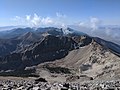
Gallery
Baker Peak and Wheeler Peak viewed from southeast
South aspect
Baker Peak (right of center) viewed from Wheeler Peak
↑ Baker, White Pine County, Nevada, Whitepinecounty.net, Retrieved September 8, 2025.
↑ Peel, M. C.; Finlayson, B. L.; McMahon, T. A. (2007). "Updated world map of the Köppen−Geiger climate classification". Hydrol. Earth Syst. Sci. 11. ISSN1027-5606.
This page is based on this Wikipedia article Text is available under the CC BY-SA 4.0 license; additional terms may apply. Images, videos and audio are available under their respective licenses.